Provincial Russian Urbanism:
Shaping Catherine the Great’s Imperial Space, 1760–96 and After
By Albert J. Schmidt
(Unpublished Work © 2021 Albert J. Schmidt)
This shaping of an infrastructural colossus achieved its apogee in central or Interior Russia during Catherine’s reign although work had originated with Peter I (1689–1725) and continued into reign of Nicholas I (1825–55).2 Appraised by Shvidkovskii and detailed by Robert E. Jones in his seminal article on urban planning,3 this endeavor, really a classical one, played significantly in Muscovite Russia’s momentous expansion.4 Jones noted the planning of more than 400 towns and cities, an undertaking which “produced a conscious uniformity of urban design throughout the empire.”5 Besides highlighting a milestone in urban history, this shaping of an empire of classical cities epitomized both the imperial vision and taste of Catherine and her successors.
Provincial Russia’s new look stemmed notably from two calamitous events—a fire which destroyed the Volga city of Tver’ in 1763 and the Pugachev peasant uprising in 1773–75—both of which revealed flaws in the management of Catherine’s sprawl. Correcting them included moving her urban planning and building apparatus from St. Petersburg and Moscow to Tver’. After inspecting a restored Tver’ in 1767 Catherine composed the Great Instruction ,which revealed her thoughts about cities. Her provincial urbanism, like Peter the Great’s Petersburg, played well politically by recasting a backward Muscovy with the trappings of a European power.
Further, this paper looks at Catherine’s urbanism through the lens of a built environment—such refurbished central Russian cities as Arkhangel’sk and Vologda in the north and others nearer Moscow such as Iaroslavl’, Tver’/Torzhok, Kostroma, Kaluga, Kolomna, and Tula.6 This is the focus rather than that of founding new ones. Not detailed here but highly germane to this urbanization are other cities in central Russia, settlements in the Russian North,7 in the south on those lands won from the Turks,8 on the lower Volga,9 in the Urals,10 and in distant parts of Siberia11—if only to show the extent of Catherine’s planning and planting an urban empire. This paper even touches on the empress’s skeletal administrative centers, those strategic cogs established by 1775 legislation to facilitate governance. Founded frequently in remote locations, most centers achieved only modest success in evolving as urban centers.12 As such standard bearers they, too, publicized Catherine II’s pursuit of a European look—a neoclassical/geometric one—conveying order as embodied by an expansive imperial Russia.
Catherine’s cities were intended to anchor her empire.13 Like those outlying ancient Rome, Russian cities were rooted in an imperial/legal system linking metropolis to province. Their classical layout–one of architectural Reguliarnost’ detailed here in select exemplar provincial cities mattered to Catherine as it had to her Roman forebears.14 Russian neoclassical urbanism, moreover, piggy-backed on a global building culture the enlightened governance of which, like Rome’s, often bore a stigma—that of autocracy.15
The conclusion examines classical urbanism after Catherine—as championed by Alexander I (1801–25) and Nicholas I and facilitated by the gifted Scottish architect/city planner and imperial strategist William Hastie (aka Geste) and architect Vasilii Petrovich Stasov. The continuity of their model projects with Catherine’s in shaping imperial space is evident in Hastie’s urban blocks and squares and residential design and Stasov’s of commercial entities. Russian urbanism considered in the context of high territoriality is also central both strategically and aesthetically to this narrative.
I. Catherine II and Enlightened Governance16
Eighteenth-century Russia was blessed with two of the ablest monarchs in modern European history, Peter I and Catherine II. Their styles of rule reflected not just differences in personality and sex, but also the sophisticated and Europeanized nature of the Russian elite by Catherine’s time.
Dominic Lieven, The Russian Empire and its Rivals
Catherine was an adventuress of genius; she was never sated by yet another military campaign, another lover, another masterpiece. Her unquenchable thirst for culture was a sort of barbaric instinct whose avidity knew no bounds, her imagination was limitless.
Germain Bazin, The Museum Age, as quoted by Katia Dianina, “Art and Authority,” p. 632.

Illus. 1: Catherine the Great in her 50s by Johan Baptist von Lampi (Wikimedia Commons).
Unlike her contemporaries Maria Theresa of Austria and Frederick II of Prussia, Catherine II did not possess an administrative infrastructure for governing, really managing her space; consequently, this enlightened empress had to invent her own. She did so especially during 1775–85, although she had taken to top/ bottom despotic planning even earlier. Just as Catherine stocked her Hermitage collection with masterpieces, she projected new towns and cities and restored old ones. In doing so, she established new vehicles for planning and building, engaged in training and supervising her architects, and even concerned herself mastering professional details. Although Russia’s need for rational government inspired Catherine’s provincial urbanism, the back story is her mentalité: the passion she evidenced changing the outlook of her subjects, at the same time satisfying her own autocratic appetite for shaping her cities. The provincial cities examined in this study are emblematic of her personal tastes as well as her pursuit of a new role for Russia in Europe. The Enlightenment was propitious for an activist like Catherine II to seize the moment: her urbanism reflected what mattered to this sovereign in this Age of Reason.17
In the early 1760s the Panin Party within the empress’s court counseled her on rational governance.18 Later, after Catherine’s marrying such rule to expansion cost her Panin support, she tapped the wisdom of French Philosophes—Montesquieu, Voltaire, Diderot, and d’Alembert—and the sculptor Falconet.19 She also found in the Swiss intellectual Friedrich Melchior Grimm a patient listener to whom she once famously exclaimed, “Our storm of construction now rages more than ever before, and it is unlikely that an earthquake could destroy as many buildings as we are erecting.”20 Besides these intellectuals Catherine relied on talented Russian architects like Vasilii Bazhenov and Ivan Starov, both apprentices in 1760’s Paris to the famed classicist Charles de Wailly (1730–98).21
The empress, moreover, proved receptive to the mercantile and administrative ideas of the German Cameralists, whose politics have been characterized as those of a “well-ordered police state.”22 Cameralists and Philosophes alike inspired Catherine’s legislative agenda, especially those reforms dating from 1775. Historian Richard Wortman has reminisced about Catherine’s winning the sobriquet Russian Minerva23 while Alexander Martin labeled her principal accomplishment the imperial social project, contending that it “created the framework for urban governance down to the era of Great Reforms.” He further represented it—perhaps over generously—as Catherine’s attempt to escape the “curse of despotism and poverty” by remaking the social estates into an enlightened third one of “new men…steeped in reason and justice.”24
While Catherine’s interaction with intellectuals from distant places and her immersion in German Cameralism seem the stuff of fiction, it was the fiery destruction of Tver’ on the Volga in 1763 and even more the harrowing rebellion led by the peasant Pugachev in 1773–75 that prodded her to act. Following Tver’s restoration in 1767, Catherine visited that city. Her inspection became an occasion for an extended Volga cruise which took her to the river towns of Uglich, Iaroslavl’, Kostroma, Nizhnii Novgorod, and even Kazan’ farther east.25
While these visitations had their festive moments, Catherine seized the opportunity to assess her imperial space. Doing so, she was mightily impressed, writing as she did to Voltaire from Kazan’:
These words signified at the awe by which this empress perceived the vastness of her space and the diversity of her subjects. Even more, she would reflect on the need to manage it in what Willard Sunderland calls a new age of high territoriality, one based on a state’s territorial sovereignty.26
After returning to Moscow from her cruise, Catherine submitted draft legislation for the Great Instruction (Nakaz) to a Legislative Commission.27 This document spoke to both her urbanism and a European vision of rational governance to replace old Russian parochialism. In it she contemplated a new role not just for reorganized provinces and towns but for a faithful nobility who lived amongst them28. That the Nakaz also included manufactures, trade, education, police, participation by a middling sort of people highlights Catherine’s thinking even before the Pugachev revolt. It was, however, that fearsome episode which sparked her Legislomania—a sequence of statutes which she authored, executed, and, above all, proved her imperial mettle.
II. Metropolis and Province
David R. Browder, (1983)
Imperial & Urban Space & High Territoriality: “The Petrine establishment now explicitly regarded territorial space as 1) a resource to be managed…2) a terrain to be shaped and molded…3) .and as a symbol of national pride…The high-water of this process…roughly coincides with the reign of Catherine the Great….This shift to a higher territorial gear was facilitated by the enshrinement of rationality and esprit geometrique as the golden rules of Russian territorial science….”30 31
Willard Sunderland, “Imperial Space: Territorial Thought” (2007)
This imperial relationship that bound metropolis to outlying province, was as crucial to Catherine’s Russia as it had been in imperial Rome. As Anthony Pagden, the respected authority on empire, observed: “Roman history offered a model….This is most obvious…in allusions to Romanimperial architecture with which the capital cities of Europe …are filled….Above all, the term empire designated an extended polity bound by a body of law.” Towns in this budding entity were not projected hither and yon; rather they were, at least supposedly, positioned rationally.32 Their shape was geometric, their texture one of “space and stone,” a landscape of intersecting thoroughfares, plazas, and masonry edifices.33
Despite the cost of Catherine’s wars and the hugeness of her urban schemes, imperial Russia did possess a means to indulge. Abetted by an affluent serf-holding nobility and a cadre of imported and home grown architects, ever resourceful Catherine benefitted as well from an economy rooted in a bountiful production of grain for export, a treasure trove of metallic wealth, and a nascent urban economy.34 Her mobilizing these assets led to a boom in serfdom which underlay the rash of her nobles’ estate building and even her own urban expansion.
Made over interior cities like those mentioned above and detailed below—from Kaluga to northern ones like Arkhangel’sk and Vologda—constituted at once a strategic core of Catherine’s empire and like others formed tentacles of her autocracy as well as a showcase for her urban achievement.35 Although administrative centers traceable to the 1775 Gubernii Statute were of limited scope, they, too, had a crucial role to play in shaping Catherine’s Russia. Called by Jones “the most extensive redistribution of administrative units ever undertaken by the tsarist regime, this legislation embodied “the redrawing of most administrative boundaries and dividing the historic Gubernii into lesser and more manageable ones which, she subdivided into districts (uezdy) and towns.”36 While projected principally for strategic purposes, some cities also improved the Catherinian landscape as well as governance. At least historian Lukomskii thought so, citing building and other improvements by newly installed governors-general like M. Krechetnikov in Tula and Kaluga; Jacob Sievers in Tver; and A. P. Mel’gunov in Iaroslavl’, Kostroma, and Vologda, to name a few (See Lukomskii, Provintsiii, p. 139.)
In decentralizing of her rule (without losing control), Catherine, as noted, relied on the nobility both to manage her imperial turf and as military servitors to combat the Ottomans. As Sunderland put it: “The intensification of [the] new territoriality of the late eighteenth century is particularly visible in the pronounced territorial preoccupations of the Catherinian elite.”37 Charters to the Nobility and Of the Cities, which followed a decade after the Gubernii Statute, further refined Catherine’s governance: in elevating her nobility to center stage, she affirmed her authority beyond St. Petersburg.38
Priscilla Roosevelt has noted how noble properties accentuated perceptions of this decentralization: “Estate architecture…encapsulated an owner’s desire to establish an identity to two opposite directions, upwards by reaffirming links to the autocrat sovereign; and downward by creating an estate reflecting a hierarchical dominance over a local serf society.” Beyond this partnership, there was status. Roosevelt discerned classical architecture’s ties with status as evidenced by lesser landowners’ mimicking the colonnaded mansions of their betters.39
One must ask why did it happen that an affluent nobility became Catherine’s crucial partner in reshaping both her urban and rural landscapes? A plausible but by no means universally accepted answer was again Robert Jones’: contemplating the horror of yet another Pugachev rising spurred Catherine to accept it. Jones went even further, maintaining that Catherine favored a loyal nobility over an incompetent bureaucracy the miscues of which had even fueled the Pugachev episode.40
This reversal of Peter III’s policy of emancipating the nobility from state service (Manifesto on the Liberty of the Nobility, 1762) was linked to a change in land tenure: the pomest’e, by which the nobility had once held land in exchange for state service, now certified their outright ownership of estate land. The consequence was a tighter control (e.g., serfdom) over the peasants who planted their fields and orchards, mined their minerals, and on occasion, not incidentally, designed and built their mansions.
Russian provincial towns which evolved from the late eighteenth century never resembled their counterparts in Western Europe.41 Indeed, economic historian Boris Mironov contended that there was little to differentiate Russian rural from urban space down to 1785, when Catherine’s Charter to the Cities required each town’s adhering to a plan.42 He attributed much of the change late in the eighteenth-century to a rise in prices, not dissimilar to that which had impacted Western Europe two centuries earlier.43 This inflation was especially consequential for the nobility and to Catherine’s politics. In this quasi-Europeanized Russia: the nobility became a privileged elite benefitting as they did from an enhanced serfdom. Their lifestyle became one of voracious consumption—travel, obsessive building—and indebtedness Truly, the nobility’s return to service proved transforming—reversing the autocracy’s time-worn policy of provincial neglect. Where legislation was key, Catherine used especially a middling nobility to manage her space. Cities and administrative centers extended her political reach, providing military and administrative footings for defense, tax collecting, surveying, dispensing justice, and advancing the public welfare.
Catherine paid a price for Russia’s becoming imperial: one of reconciling long-term territoriality with the immediacy of solving local problems. Historian Janet Hartley articulated this problem, by asking: “To what extent did the eighteenth-century autocracy allow or encourage genuine devolution of power to the provinces? Historian Sunderland rightly concluded that “new ideas and practices of territory influenced both the nature, the aspirations of state power, and the national/imperial belonging of state elites from late Muscovy to the age of Catherine the Great.”44
Expansion proved double-edged for Catherine’s urbanism: decentralization did not lessen; rather it fed the “well-ordered police state.”45 Russian cities/administrative centers followed Roman practice of maintaining a bureaucracy intended to dazzle subjects: the planning and building in the provinces conveyed a message of order, power, and secularism, embodying the autocracy as identified by Browder and what Charles Tilly called “the long, strong arm of empire.”46
The Seventeenth Century Landscape

Russia 1618–1654, After P. Bushkovitch, Merchants of Moscow, map p.28
.")
At Home On the Volga—17th Century Nizhnii Novgorod (SMA).
.")
City Life: Smolensk, 1610 (SMA).
.")
Map of Moscow, 1643 (SMA).
III. Reguliarnost & Gradostroil’stvo: An Anatomy of Classical Urbanism47
Spiro Kostof. (1936-81), The City Shaped
Urbanism’s Vehicle: “The Commission on Masonry Construction for St. Petersburg & Moscow” was crucial during this period of urban planning, 1760-1790.
F. Savarenskaia, O. Shvidkovskii, & F. A. Petrov. Istoriia gradostroitel’nogo iskusstva (History of Town Planning Art) Moscow, 1989).
If, Your Majesty, you could wave your magic wand and build as many houses as you liked instead of palaces, I should still repeat my appeal to you: ‘Build streets.’ And this indeed was done, in all provincial and district towns in Russia, with great energy and determination.49
Diderot to Catherine II as quoted by Shvidkovskii.
Catherine’s success in reshaping Russia’s imperial space, notably the urban, was measured by practicality and taste no less than politics. Historian Shvidkovskii had it right when he emphasized that imperial control over architectural details was such that “only the power of the monarch could accomplish such immediate transformation through construction.”50 Catherine’s authority in determining the look of new edifices and the shapes of her towns was formalized in newly minted town plans, as described by Kostof; the only limit on such authority was the Russian expanse.
So it was that urban shaping proceeded at an unparalleled pace from early Peter I to Catherine’s death (1796), or more accurately, to Alexander I and Nicholas I. Although architects transformed tormented building assemblages—hovels, crowded commercial stalls, and littered courtyards on crooked streets into a verticality of columns—the non-financial costs were also dear. As Daniel R. Browder observed: “Alongside the monumental public buildings the inhabitants took on the proportions of dwarfs”51 Then. too, the architecture of classicism found unqualified acceptance in Russian towns, especially when model designs by decree trumped topography.52
The unwavering line, heralded by the French classicist Pierre Lavedan (1885–1982) as “the very expression of human reason and will,” was crucial in the organization of classical space, whether that of St. Petersburg or Russia’s provincial cities. This exacting line found expression in street configuration, especially axial dominance, and in the linear effect of uniform frontal facades adhering to the “red line” of the street and unbroken horizontal roof lines.53
Lavedan offered a second dictum, a spatial one—whether private or public; square, oval, circular, rectangular, or that reserved for straightening and paving streets. The town center received special consideration, as planners matched architectural look with function. This plaza as public space organized for a monumental perspective was also figured in the politics of the classical landscape: centrally positioned palaces, essential for such an ensemble conveyed a message of power and majesty. In provincial Russia the governor’s residence and especially the edifices of the military occupied commanding sites. Structures accommodating the bureaucracy—the military, judiciary, finance, and police—were also among the few faces of the faraway autocracy which provincials encountered, and then only in select urban centers. When provincial officialdom—ensconced in elegant edifices—issued imperial edicts, subjects were expected to be awed as well as compliant. Newly minted town plans spoke to this matter as well.

N. F. Gulianitsskii on the City Center in Planning the Classical Russian City

V. A. Lavrov on Regular Plans of Small District Cities, Late 18th Century
An elite nobility was a principal beneficiary, especially, of spacious town centers. Residences there were enhanced by a classical/masonry backdrop—one brightly painted and with an infrastructure of paved thoroughfares leading into the plazas. In sculpting this central void, architects of classicism also planned and planted edifices germane to public health, education, and charities.54 For the privileged few renovated provincial towns brought a new scale of living and social climbing. Public space, the street, long the venue of the people, acquired exclusivity as a preserve for promenading aristocrats and uniformed officers with their ladies.55 Notwithstanding a prevailing provincial boorishness, building surged and its refinement glossed aristocratic provincial society.56
Where cleanliness and hygiene were a concern: factories, coachmen’s stables, tanneries, slaughterhouses, cemeteries, and the like, were shunted to outlying areas. Moving factories—even those in a classic mode—downstream, laying water pipes, and digging drainage trenches accommodated both sanitation and appearances. The cost of this infrastructure, particularly that of the first zone, was presumed the state’s responsibility.57 In treating towns as regal enclaves, the autocracy not infrequently trampled on property rights in pursuit of this royal aesthetic.58
How does one square this narrative of a late eighteenth-century provincial Russia punctuated by urban renewal with a rural Russia of estates belonging to a nobility and in the throes of serfdom? Arguably, this is a portrait of the Moscow region and beyond in the latter years of the reign of Catherine. Historian Paul Dukes suggests dividing this entity into a half dozen clusters, citing: 1) the lower and middle landlord estates, which lay to the south of Moscow along the old Crimean Tatar defense line near Kaluga, Tula, Riazan, and sizable portions of Orel; 2) estates northwest of Moscow around Smolensk, Pskov, and St. Petersburg, once a barrier against Poles and Swedes; 3) lands formerly belonging to tsar and boiars, including Iaroslavl’ and Kostroma north of Moscow; 4) estate lands nearer to and including Moscow with scattered estates of wealthy nobility and churchmen in the north; 5) lands around Voronezh, Penza, Simbirsk and Saratov, which became estate property of nobility; properties of state and church peasants around Novgorod, Vologda, Kazan’, and Perm as early as Ivan IV in the sixteenth century; and 6) a few estates in the far north near Arkhangel’sk, Viatka, and Siberia.59 These lands were in transition: quasi-rural becoming urban.
Catherine’s planners divided towns into workable units, rings, accessible to building materials.60 Hypothetically, new construction utilized the brick and stone of old structures in the center, when the first ring was occupied by, say, a kremlin. Less pretentious masonry housing with continuous facades in the same ring faced restrictions in frontal design, height, width, and paint color. As Shvidkovskii has noted, even private houses were subject to official approval and police enforcement.61 A second ring was reserved for small houses and shops, built of wood but usually on stone foundations. Building materials notwithstanding, row houses with continuous facades were fire hazards. Those in a third band, the largest, were wholly of wood; even when flush with the street they rarely possessed a continuous facade.
`Russia’s classical cities, like those in the Grand Baroque Manner of a European one a century earlier, assumed diverse shapes—radiocentric and fan-shaped being the two most frequent with rectangular and diagonal patterns incorporated within these.62 The first, which as noted, frequently evolved from a kremlin of protective walls, was translated into a hub with concentric boulevards pierced by radial thoroughfares. Such a radiocentric pattern dominated Moscow’s center while Kostroma’s took on near perfect fan shape. In this aura of abundant public space and linear articulation Russian planners inserted bridges, embankments, and gridiron blocks, straightened riverbeds, and paved canals.
A geometric reordering linked Russian towns not only with the Petrine baroque of St. Petersburg but also with the building styles and layouts of Antiquity and Renaissance Europe.63 Historians as diverse as Igor Grabar’ and Dmitrii Shvidkovskii favored French antecedents, while classicist Georgii Lukomskii tilted toward those of Renaissance Italy. Shvidkovskii equivocated on Russia’s architectural debt to France, crediting military engineers as well as Bazhenov’s classical Kremlin, which had once seemed destined to redefine Moscow.64 There were diverse styles and favorite architects in Catherine’s repertory: by the 1770s her tastes had evolved from a liking of German rococo to a preference for Palladian classicism “that combined the purity of French classicism with a sensual appreciation for…Roman forms.”65 Infatuation with the artistry of Charles Cameron prompted Catherine’s reshaping palatial Tsarskoe Selo, an undertaking intended to link her classicism to that of William Hastie’s, and the making of an exquisite village named Sofiya.66
While it strains credulity to speak of an urban renaissance in late eighteenth-century Russia, numerous towns in the Interior did assume a regular look under the initiative of such Catherinian governors as Krecheshnikov in Tula and Kaluga, Jacob Sievers in Tver, Mel’gunov in Iaroslavl’ Kostroma, and Vologda, and Vorontsov in Vladimir. Their geometric planning and building became synonymous with modernism. Robert Jones held that Catherinian design, which “established the appearance and the character of the modern Russian city,” represented one of the great legacies of this period.67 That Catherine, as noted above, “envisaged the towns as centers of health care, education, and public welfare” also signified classicism’s modern edge.68 Despite its disconnect with Old Russian culture, classicism did win acceptance from diverse constituencies, becoming the badge of such proud elites as the monarchy, nobility, and even a coterie of wealthy urbanites.69 This was especially true of Empire classicism, fueled by the martial glory of 1812–15.70
This new urban look did not just happen. Between the reigns of Peter I and Catherine II—especially with St. Petersburg and Tver’ as models—a mix of talented architects and a well-organized building apparatus spawned an era of rococo/classical building. Besides the construction which coalesced in St. Petersburg and Moscow also impacted their suburbs. As Wortman observed, architects built edifices “that gave Russia its own imitations of Roman architecture.” Such emulation “transposed the political spirit of Rome to St. Petersburg and its environs.” Then, too, foreign architects like Charles Cameron were pivotal in bringing the art of Palladio (1508–80), to Russia.71
By the early 1740s students were learning architectural drawing in the Moscow workshops of Ivan Korobov (1700–47) and Ivan Michurin (1703?–63), both of whom had studied architecture abroad.72 Creeping professionalism became evident by mid-century in a Moscow school founded by the baroque/rococo master Dmitrii Ukhtomskii (1719–74).73 This institute nurtured, among others, the talented Vasilii Bazhenov (1737–99), Petr Nikitin (1735–90s), and the most durable of them all, Matvei Fedorovich.Kazakov (1738–1812). Included also was the transitional (baroque/classical) architect Ivan E. Starov. Planner in Iaroslavl’, Voronezh, and of towns in New Russia, he had studied in Paris, as noted, with the classicist Charles de Wailly.74
The best known of late Catherinian architects were those of the Kremlin School. Founded in 1768 and connected with Bazhenov’s Kremlin makeover, it was involved transforming Old Moscow into a classical one. The faculty included Bazhenov, who had studied abroad as well as under Ukhtomskii, and was himself mentor to Kazakov. Eventually, the latter, tutored, too, by Nikitin, took over the headship of the Kremlin School. As one contemporary observed: the school founded by “the most famous and able architect Kazakov…filled not only Moscow but also all Russia with good architects.” Elizvoi Semenovich Nazarov (1747–1822) and Ivan Vasil’evich Egotov (1756–1814) were early graduates who left their mark on provincial urbanism.75
Catherine’s earliest undertaking to centralize urban planning had been the appointment in 1762 of a Commission for the Building of St. Petersburg and Moscow. This central planning agency—which included generals, dignitaries, and corps of architects, surveyors, clerks and initially under architect Aleksei Kvasov—served Catherine in matters of urban building for the remainder of her reign.76 That urban police stringently enforced Commission plans signified the importance the empress attached to these “guardians of [both] the physical and moral order in the towns.”77 Similarly, a new Masonry Bureau (Kamennyi Prikaz),dating from the 1760s, became a vehicle for upgrading Moscow in accord with that city’s 1775 plan.78
Catherine’s urbanism went beyond the aesthetics of architecture and the artistry of model design albums; it demanded precision in the drafts of city plans, maps, and blueprints; those urban monuments which filled spatial voids and inspired patriotism; the works of talented artists who advertised the new urbanism through cityscapes and views and pictures of edifices and monuments which often provided marginalia for maps and city plans. Kazakov’s watercolor of Tver’ was special in documenting the city’s restoration in 1763.79 Urban scenes like those by the painter Fedor Iakovlevich Alekseev (1753–1824), also won an audience for urbanism, and even nascent nationalism.80 Such sentiments were especially evident in painting the of centennial unveiling of Poltava’s Glory monument.81
Classical urbanism benefitted from the improved draftsmanship of the new cartography and town planning. Historian James Cracraft, moreover, has cited the newly-established Academy of Fine Arts for its offerings in drawing and drafting which spurred architecture, etching, engraving, lithography, and painting as “the chief agency perpetuating [a] Petrine visual revolution”82 and figured institutionalizing the Grand Manner style. S. Frederick Starr perceptibly noted that the Academy’s direct control
The increased output of meticulous maps and town plans accurately and eloquently extolled the virtues of empire, especially in marginalia of mythological, military, and architectural representations.84 As Steven Seegel framed it: “Catherine used maps as expressions of enlightened governance….[Her] maps of…borderland frontiers functioned as a kind of master blueprint for empire.”85 Early in the nineteenth century, especially, albums of model projects and blueprints for city blocks and plazas became preferred media for publicizing a Europeanized Russia in the making.86
Model projects proved critical in planting classical cities/towns in remote places where professional architects were lacking but where their expertise in design if only in albums was required for residential and public buildings, or even stark factories. While such models had been utilized during Peter I’s and Catherine II’s reigns, their apogee occurred under Alexander I when many newly minted plans were approved and issued promptly by one in authority, not infrequently one William Hastie. This master strategist, whose crucial role is detailed below, authored architectural model projects as well as authorize numerous city plans.
Through this new authority and imagery light was shed on both the near provinces and the hinterlands of the North Dvina, the northern and southern reaches of the Volga, the Urals, and even the distant Altai.87 Geographic images, descriptions, and maps gave this Russian expanse a face hitherto unfamiliar to Russians living in and near the two capitals as well as in Western Europe.88 That Academy stalwarts, the St. Petersburg masters Adrian Zakharov and Karl I. Rossi, took Altai and Siberian students under their tutelage is indicative of both the search for talent as well as imperial reach.89 Nearer at hand, cities like Odessa and Kiev cast a further classical glow, emblematic of their new urbanism’s descent from a rich architectural past.
While Catherine’s main purpose in establishing administrative centers in 1775 had been one of governance, people did matter.90 Alexander Martin’s thesis of: Catherine’s imperial social project—that is, one of transforming backward peasants into industrious and virtuous Europeans—is intriguing and even compatible with Martin’s notion of an emergent bureaucratic “middling sort.” Did Catherine ponder possible collaborators with her nobility?91 While the lives of such late-eighteenth-century personages are elusive, David Ransel’s and Alexander Martin’s biographies suggest Catherine as a sometime urban reformer92 to which even Robert Jones subscribed:
The 18th Century Scene

Portrait of Architect Vasilii Ivanovich Bazhenov, 1739–99 (Wikimedia Commons).

Portrait of Architect Matvei Fedorovich Kazakov, 1738–1812 (Wikimedia Com.)

Portrait of Architect of Ivan Egorovich Starov, 1744–1808 (Wikimedia Com.)

Academy of Fine Arts, St. Petersburg, 1765–89 (Wikimedia Commons).
Photo credit: Alex ‘Florstein’ Fedorov
")
Smolensk, Newly Minted Plan of 1779 (SMA).
")
Classical Moscow, Architecture as Marginalia (SMA).
IV. Catherinian Russia’s Built Environment, per Baron August von Haxthausen, 1840s
August von Haxthausen, as quoted in William Blackwell, The Beginnings of Russian Industrialization 1800–1860, p. 99.
Haxthausen’s 1840’s portrait of a provincial landscape, e.g., “Catherine’s town” is telling: despite Catherine II’s urbanism the traditional village continued its coexistence with newly built urban space. Citing Haxthausen also introduces the ambiguities of Russia’s urban demography, a composite of the scholarship of Robert E. Jones, Arcadius Kahan, Boris Mironov, William L. Blackwell, Thomas Stanley Fedor, Adna Ferrin Weber, Gilbert Rozman, and the incomparable V. M. Kubuzan, each of whom spoke to this crucial aspect of imperial Russia’s budding urban scene.
Jones linked this demography with planning as evidenced in his treatment of the Commission on the Building of St. Petersburg and Moscow;95 Mironov won plaudits for his study of the eighteenth century price rise in Russia; Arcadius Kahan, meanwhile, placed his work on a firm scholarly footing by linking demography to economics in his study of Russian towns, some of which are detailed in this paper. Kahan’s citing Kubuzan as the leading [late nineteenth] specialist on Russian historical population studies gave credence to his own work.
In his demographic treatment of central Russian cities Kahan noted that “more than 8 percent of the population lived in cities during the 1780s.”96 Further, he concluded Moscow’s and St. Petersburg’s population at more than 100,000 each with a combined population of perhaps 400,000.97 Although finding no cities numbering 50,000–100,000, he did include Tula, Kaluga, and Iaroslavl’ among the three with an estimated population between 30,000 and 50,000. He placed Tver’, Arkhangel’sk, and Kostroma in the 10,000 to 20,000 range. Of the towns examined below, only Vologda and Kolomna had fewer than 10,000 inhabitants: by the eighteenth century Vologda’s role in commerce had diminished, while Kolomna’s had never been notable.98 Blackwell, using the dates 1811 and 1840, numbered Iaroslavl’ (23,800 and 34,900), Tula (52,100 and 51,700), and Kaluga (23,100 and 35,000).99 Kahan placed Tver’, Arkhangel’sk and Kostroma in the 10,000 to 20,000 population range. Thomas Stanley Fedor also examined nineteenth-century Russia’s urban population while Rozman, like Kahan, drew on the legendary Kubuzan.
How and when did Catherine’s new or renovated urban centers assume final shape? To judge from Catherine’s disdain for old Moscow she certainly expected her cities to adhere in good time to reason and order, features that fixated all enlightened monarchs. Had not Peter I years earlier banished wooden sprawl on Moscow’s Iauza River by replacing it with a classical Lefortov district? Then, too, Catherine and then Alexander, had forged a classical Petersburg and even contemplated doing the same with Moscow. Provincial urbanization, once begun, seemed never ending, certainly proving to be a task exceeding the making of even a classical Petersburg or Moscow. Historians have proved extraordinarily innovative in narrating it.
VI. Catherine’s Built Environment: Making Nine Classical Cities
Russia’s provincial cities, especially those founded as administrative centers, have on occasion been labeled “artificial” or unrealized. Arkhangel’sk and Vologda were neither. In the north, where the White Sea was key to the Russian economy, the former was founded a century and a half before St. Petersburg. This alternative to Western European markets dated from 1553 when an English vessel arriving in the North Dvina inaugurated White Sea traffic. By 1585 the city of Arkhangel’sk, newly founded on the site of a monastery, had replaced Kholmogory as the principal regional port. In less than a century—the Dutch, having superseded the English in the Russian trade—it became a major entrepot for north European traffic.100
Although sables were largely extinct in the Russian North even by the seventeenth century, they were brought to Arkhangel’sk from Siberia. Salt and copper, exploited especially by the Dutch, were also preeminent in the northern commerce. The port, moreover, was important for the grain market, principally for transshipping Volga rye to Europe. Vologda and Tver’ merchants and even those from Kaluga, Tula, and Kolomna used it as their port from the early eighteenth century.101
The White Sea route was highly problematic: passage between the Atlantic seaboard and Arkhangel’sk was exhausting and dangerous, moreover, the harbor’s shallow waters necessitated unloading incoming cargo onto smaller craft and storing in the Moscow Merchant’s House (gostinyi dvor) before shipment to Moscow. This wooden structure, which combined merchants’ quarters and a warehouse, was probably the largest of its kind. Consisting of 170 rooms and about as many stalls, it was the preserve of the Moscow merchants. Foreign peddlers were forbidden advancing beyond it.102 Following its destruction by fire in 1667, its successors were built of stone.
Perched at the tip of a peninsula jutting into the North Dvina, Arkhangel’sk even today evidences the contours of a classical city. The fan-shaped streets emanate from an interior hub toward the river. The city’s axial and central Voskresenia thoroughfare, which originates well beyond the regulated peninsula, fans from the second plaza in its path. It and the other radial streets intersect with the long North Dvina Embankment rather than converge as in Kostroma. The Arkhangel’sk plan was slightly irregular, its city blocks being imperfect squares; at the north end, the angularity of the plazas accommodating the shoreline of the Kuznechikha River. The plans of both 1784 and 1794 show a geometric street grids which continued into the city’s Solombala quarter across the river. Positioned at the intersection of the radial thoroughfares with the North Dvina were imposing edifices, among them the cathedral and the gleaming 1797 gostinyi dvor. Standardized middling (meshchanskie) dwellings also were a determinant in the city’s look.103
Yet it is a mistake to exaggerate classical Arkhangel’sk masonry cast: at the end of the nineteenth century, it was still, par excellence, the wooden city. An “Arkhangel’sk house,” according to a nostalgic writer, was one “largely standard in design and construction, but endlessly variable and individual in detail and richly decorated in a national style.”104
Arkhangel’sk’s commerce stimulated the economies of other northern towns—Velikii Ustiug, Tot’ma, and, especially, Vologda and Iaroslavl’.105 Goods brought into Arkhangel’sk from Europe and destined for Moscow was moved south on the North Dvina to the Sukhona and then on to Vologda on the Vologda River, until winter when these rivers froze. Long a way station for goods shipped from the north, even before the founding of Arkhangel’sk, the city was pivotal vis-a-vis Iaroslavl’, the principal distribution center for incoming European goods.106 Vologda, like Arkhangel’sk, had its merchant’s frame warehouse, which included storage rooms, a hotel, and a church.
* * * *
The merchant trek from Vologda along the Moscow road was routinely delayed until winter when hard-packed snow made travel by sled easier. Merchants either passed through Iaroslavl’ en route to Pereiaslavl’ Zalesskii, Rostov, and Moscow, or they simply lingered in Iaroslavl’ from which they shipped their wares to other Volga towns. Like Arkhangel’sk, seventeenth-century Vologda engaged in the salt trade, which originated in Solovetskii Monastery, along White Sea shores at Tot’ma, and nearby Spaso-Prilutskii Monastery. The city also prospered during these years from commerce in copper.
Vologda enjoyed political prominence in the sixteenth century when it served as both an administrative center and a refuge for an embattled Ivan IV. For a time, he may even have contemplated making the city his capital. That Catherine II designated Vologda, Arkhangel’sk, and Velikii Ustiug provinces vicegerencies (namestnichestvy), principally to maintain order in the Russian north, no doubt motivated her sprucing it up.
Vologda’s inviting site consisted of 1) the City (Gorod)—the kremlin, Sofia Cathedral, and the famed Archbishop’s Courtyard—located at the Vologda River’s confluence with the Zolotukha; 2) the Lower Settlement (Nizhnii Posad), adjacent to the Archbishop’s Courtyard; 3) the settlement beyond the river (Zarech’e); and 4) the Upper Settlement (Verkhnii Posad). The replanning of Vologda at the end of the eighteenth century resulted largely from the changes in the first two site elements; however, building merchant villas in Zarech’e along the river and alterations of the Upper Posad played significantly in making Vologda classical.
Although Vologda did not acquire so pronounced a /geometric look as did Tver’, Kostroma, or Kaluga, a renovative plan had actually begun earlier. Confirmed as a namestnichestvo with a governor in 1780, the essential configuration of the city had been evident as early as 1700. At that time many of its numerous wooden structures, especially churches, were razed and replaced by masonry ones. The Archbishop’s Courtyard, the center of the seventeenth-century city, remained into the next. For Vologda, as with other towns, natural disasters—a fire in 1773 and flood in 1779—effected its classical conversion.
The geodesic survey made after the fire of 1773 showed the Lower Posad reaching beyond the Little Blagoveshchenskaia to those cross streets which in recent times constituted the Oktiabrskaia/Hertzen Ring. As Lower Posad’s street grid veered toward the river, the Piatnitskaia (sometimes Mal’tsev Street), became the central axis converging on the Sofia Cathedral in the Archbishop’s Courtyard. The city limits in Zarech’e stretched only to Kalashnaia, or modern Gogol Street.
The architects of a new Vologda likely pondered street configuration long and hard, for the Piatnitskaia had no place to go. Although its termination in the vicinity of the Archbishop’s Courtyard was feasible, the space (which became Gostinodvorskaia Plaza and more recently Pobeda, or Victory Prospekt) at the convergence of Piatnitskaia with the lower Great Blagoveshchenskaia (more recently Batiushkov) was too small to be monumental. What to do?
A group of architects led by Petr Trofimovich Bortnikov devised a novel solution. They joined the Archbishop’s Courtyard, which, after all, was the city’s earliest central plaza, to a new administrative center. They did so by shifting the Great Blagoveshchenskaia/Kirillovskaia (later Mirskaia) axis roughly forty-five degrees toward the Zolotukha River, where endless space allowed for a cavernous square. This diversion of an axis, which had originally pointed toward the Courtyard, resulted in its resting nearly perpendicular to the old grid. In the newly configured Nizhnii Posad the axial streets converged on a monument far less auspicious than the ancient archepiscopal complex: it was simply a single-arched, four-towered stone bridge, which spanned the Zolotukha River. However nondescript initially, this sector of the river front was soon inundated by commerce and made fashionable by promenading gentility. At the confluence of the Zolotukha and Vologda Rivers a spacious administrative plaza took shape. Rectangular with symmetrical half circles on each end and pierced by pairs of diagonal and perpendicular streets, they presented striking contrasts, as evident in the 1784 plan, to the old city center altered just a few years earlier.107
The fire of 1773 and the flood six years later spurred both planning and masonry building. The changes wrought during these years by architects A(lexander?) Bortnikov, Sokolov, and perhaps the most important among them, Levengagen, effectively elevated this ancient city to a resplendent classical one. Although dating classical architecture in Vologda is imprecise, the most important official structures—the governor-general’s mansion and administrative, commercial, and public buildings—were erected in the 1780s and early 1790s. The same was true of masonry residences, the most impressive of which were built along the embankment. A rococo lag, however, punctuated by their flat facades, ornament, cornices, voluted pilasters, and countless windows prevailed among them.
The governor general’s mansion was one of the first masonry edifices (1780–83) after the designation of Vologda a namestnichestvo. Built according to Levengagen’s design, it was massive, L-shaped, and also reflecting the rococo lag characteristic of provincial architecture of this period. Absent the portico and pediment which high classicism demanded, the building instead featured cylindrical corners and myriad windows, twenty-four of which reached across the facade.108
The Zarech’e Embankment with its late eighteenth century chic homes typified the new Vologda. A few of these masonry mansions, like the merchant’s dwelling on the Sreteiskaia (later Third Red Army, or Krasnoarmeiskaia) Embankment survive.109 To this day it remains a handsome and substantial two-story block the facade of which is interspersed with ornate pilasters, cornices, and windows capped with lintels. Another late rococo survivor, no. 25 on the embankment, dates from 1777. Also replete with luxuriant windows, cornice, and pilasters, it has an eye-catching facade the lower portion of which is rusticated.110 Admiral I. Ya. Barsh’s estate at no. 11 was the most stately on the quay. Its facade brandished a dozen pilasters and eleven windows on each of its two stories as well as a flashy cornice and equally dazzling wall ornament in relief.111 Nearby (on what later became Red Navy, or 16 Krasnoflotskaia Embankment) Maslennikov House was of a plainer sort but recognizably rococo from its array of pilasters, cornice, and windows.112 The sugar refiner Vitushechnikov and the merchant Varakin also built riverside homes, at once imposing yet unpretentious compared to earlier rococo and later classical ones.113
One exception to this late rococo bloom, at least regarding its river facade, was the Skuliabinskaia Almshouse. This early 1780s edifice, devoid of ornament, bore a powerful six-columned portico with pediment and rested on an elevated foundation. Like the massive Indigents’ Hospital, it was reworked in the classical style of the next century. Its two-story facade of twenty-one windows across shouldered a six-columned portico with pediment; a wing at one corner was capped with a cupola.114 These new embankment edifices and the street configurations gave a classical glow to this ancient city.
")
Illus. 14: Plan for Classical Arkhangel’sk, 1794/1839 (PSZRI)
")
Illus. 15: Arkhangel’sk Market & Warehouse, 1797 (Schmidt)
")
Illus. 16: Vologda River View (Schmidt)
")
Illus. 17: Vologda, Archbishop’s Courtyard (Schmidt)
")
Illus. 18: Vologda, Archbishop’s Courtyard (Schmidt)
")
Illus. 19: Vologda, 1784 (SMA)
")
Illus. 20: Volodga, Barsh House, 1806 (Fekhner)
")
Illus. 21: Vologda, Barsh House Today (Schmidt)
")
Illus. 22: Vologda, Skuliabinskaia Almshouse, 1780s/Today (Schmidt)
Next to the White Sea the Volga River basin was Russia’s central avenue of commerce during the seventeenth century. It drew trade from Arkhangel’sk in the north and Astrakhan in the south, where Persian ships unloaded their silk.115 This southern commerce, moreover, greatly enhanced down-stream settlement. The Volga trade, however, had a huge drawback: although ships moved easily with the current, they had to be rowed upstream. The first two stops from the south were Kazan’ and Nizhnii Novgorod, from which merchants often transshipped their goods, either by way of the Oka or overland. Cities like Iaroslavl’, Kostroma, Tver’, Nizhnii Novgorod, and Kazan’—disheveled, unsanitary, and fire prone—not surprisingly were slated for Catherine’s urban renewal; Iaroslavl’ Kostroma and Tver’, hence, were redefined.116
* * * *
")
Illus. 23: Development of a Regular Plan for Iaroslavl’ (Lavrov)
Iaroslavl’, situated about 250 kilometers northeast of Moscow, was well-positioned to accommodate both the northern and Volga trade. It served uniquely for transshipment and as a commercial center for the fairs which it hosted.117 The city also had a land-based economy, one exploiting the northern forests and textile manufactures for both foreign and home markets. That cattle pastures figured prominently in the landscape joining Iaroslavl’, Kostroma, and Kazan’ suggest still another aspect of the regional economy.118
Having originated as a trading post nearly a thousand years ago, Iaroslavl’ stood second only to Moscow as Russia’s preeminent urban center until the founding of St. Petersburg. The lucrative English and Dutch trade through Arkhangel’sk had brought the city prosperity and stimulated a cultural renaissance evident even today in its comely churches, monasteries, and very own school of icon painting.119 Affluent Iaroslavl’ merchants indulged themselves as patrons of cosmopolitan artists who emulated Western architectural motifs—all before the inroads made by classicism.
This Volga city’s edifices did not, however, mesmerize everyone. After debarking from her cruise in 1767, the Empress Catherine pronounced Iaroslavl’ “beautiful in location but abominable in building.”120 She reiterated this by calling for a new plan to counter the city’s disorder and prevailing woodenness.
Old Iaroslavl’, which backed onto the Volga at its confluence with the river Kotorosl’, was essentially of two parts—the Log City, (Rublennyi Gorod), consisting of the kremlin and cathedral center and Suburb, and the Earthen City (Zemlianoi Gorod).121 Even before Catherine’s reconfiguration of Iaroslavl’ the Rublennyi Gorod received less attention than the Zemlianoi Gorod. The latter, its ramparts anchored by the Spasskii Monastery at the Kostorosl’, invited traffic from Uglich.
One is hard put to ascribe any particular style to modern day Iaroslavl’. It is at once medieval, Muscovite, and classical; even its classicism ran the gamut from that of the eighteenth to the twentieth centuries. A fire in 1768, following Catherine’s visitation, proved an impetus to planning which she had initiated by destroying wooden structures in both the kremlin center and Suburb. The next year she charged the St. Petersburg and Moscow Building Commission to redesign the city.
In 1769 chief architect Aleksei Kvasov proposed the usual division of the city into a center for government and public buildings and the outskirts for housing and the kind of dirty industry and commerce deemed inappropriate nearer in. Like Arkhangel’sk and Vologda, Iaroslavl’s role in internal commerce required its having a sizable storage facility. Two and three story-buildings in the city center were designated for masonry construction; single-story structures, both masonry and wood, were relegated to the outskirts. The rationale for the plan bespoke the usual litany—fire-proofing, sanitation, and aesthetic. No matter, it evoked opposition and was abrogated at the request of the vicegerent, A. P. Mel’gunov. The reason for this rejection is not clear; the Iaroslavl’ plan was hardly atypical. Its lack of distinctiveness may have been the problem, for Kvasov had failed to incorporate those monuments which became centerpieces of the classical city.
Nearly a decade later, in 1777 Iaroslavl’, indicative of its economic and demographic growth was designated a super vicegerency, or governorate; the first holding that office being Mel’gunov.122 Having played a decisive role in disposing of Kvasov’s plan, he immediately pressed for a new one. This plan, possibly of Ivan Starov’s authorship, was completed and confirmed by Catherine the following year.
More sophisticated than its predecessors, Starov’s embodied landmarks: encompassing the area between the Volga and the Earthen City boundary, the future classical city took the shape of a trapezoid. Its streets fanned from a central plaza, the Il’inskaia, by the late 1780s Iaroslavl’s hub. Its most important monument was the mid-seventeenth-century Temple of Elijah the Prophet (Khram Il’i Proroka, 1647–50). Before the century’s end two massive administrative edifices joined the church which was positioned at the intersection of the proposed prime axes. One of these paralleled the Volga between the Semenovskie Gates and the Assumption (Uspenskii) Cathedral in the kremlin; two others, pitched to form a trident, stretched from the Elijah Church to the Uglichskie and Vlas’evskie (Znamenskaia Tower) Gates. These two radials—the Rhodestvenskaia and Uglichskaia—were projected to terminate in the plazas at their intersection with Volga-aligned streets. During Alexander I’s reign the first permanent Kotorsl bridge was erected and the Volga embankment stabilized thereby allowing for the construction of a decorative pavilion and promenade (see below) classical landmarks also of Alexander ’s time.
However impressive this building program in Catherinian Iaroslavl’, the making a classical city’, indeed, was Alexandrian. Boulevards replaced the wooden Earthen City ramparts and moats; the bridge across the Medveditskii Ravine was pulled down and the chasm itself partially filled. As noted, stunning stone embankments, walkways, and tasteful edifices transformed the Volga river front! A gostinyi dvor (noted below), contemplated as early as the late 1770s for the site of the old Earthen City wall, was finally realized under Alexander.
Alexandrian Iaroslavl’ has been identified especially with the works of the classicist Petr Yakovlevich Pan’kov (1770–1842).123 This gifted draftsman, who served as provincial architect from 1823–42, was responsible for the mansion ensemble of the governor (1819–20), the city theater (1820), and the Mytnyi Market (1820–23). In the Il’inskaia he built a massive eight–columned Corinthian structure for an expansive bureaucracy before modifying other state buildings there. Pan’kov’s talent for the classical/monumental was further evidenced by a six-columned portico/pedimented theater and the Demidov Lyceum fronted by a towering twelve-columned Corinthian portico without pediment (1825). His Goriainov House, later successively, the Pedagogical Institute and Kommunal’nyi Bank, was also highlighted by powerful Corinthian verandas.
Iaroslavl’s long-awaited gostinyi dvor, another Pan’kov creation, was erected (1814–18) on the site of razed Earthen City walls and centered on the Elijah Church. It was his most distinctive work and among the best of its kind in Russia. Shaped as a trapezoid with Ionic accouterments, it was separated into nearly equal parts by a semicircular entrance. This foyer centerpiece featured a dome and Ionic portico while an Ionic colonnade enveloped the entire building. Taken together these works validated Pan’kov as a master builder of public edifices. Their severity—devoid of rococo embellishment—placed it squarely in the mode of the new classicism.124
")
Illus. 24: Classical Iaroslavl’, 1799 (SMA)
")
Illus. 25: Classical Iaroslavl’, 1839 (PSZRI)
")
Illus. 26: Iaroslavl’: Volga Embankment (Schmidt)
")
Illus. 27: Iaroslav”l, Medical Society Bldg. on the Volga Embankment (Schmidt)
")
Illus. 28: Iaroslavl’, Office Building, Ill’inskaia Square, P. P. Pan’kov (Schmidt)
 , 1813–21, Architect P. P. Pan’kov (Schmidt)")
Illus. 29: Iaroslavl’: Market (Gostiny Dvor) , 1813–21, Architect P. P. Pan’kov (Schmidt)
")
Illus. 30: Iaroslavl’: Same Market by P. Pan’kov (Schmidt)
* * * *
")
Illus. 31: Development of a Regular Plan for Kostroma (Lavrov)
Kostroma, which dated to the mid-twelfth century, took shape on the north bank of the Volga at its confluence with the Kostroma River.125 Despite the city’s proximity to bustling Iaroslavl’, it was never a notable player in the Arkhangel’sk trade. Rather it faced in an opposite direction, the lower Volga, where its enterprising merchants bartered for silk, engaged in the modest central Russian salt industry, and exploited the sizable timber resources in their midst. The surrounding grasslands, extending all the way to Kazan’, served also as excellent pasture.126
Medieval Kostroma with kremlin and churches possessed a coherence uncommon for historic urban sites: the Monastery of St. Ipaty, at the juncture of the two rivers, was a fixture in the local landscape, both medieval and classical. By Catherine’s time no provincial city in Russia garnered so great an architectural elegance as did Kostroma.127
A signal event in the city’s history which made this possible was the great fire of 1773, which swept away most of the wooden kremlin. This disaster, coupled with Kostroma’s economic expansion, hastened the city’s inclusion in the Catherine’s planning/building repertory. The city’s initial plan (1773), proved inadequate in that cluttered housing continued to impede the straightening of streets. Even a variant plan completed two years later did not immediately improve matters: although it had been decided early on that the city center would be a point of convergence for aligned radial thoroughfares, a 1775 version underwent successive modifications in 1778 and 1779; another correction by the Commission for the Building of St. Petersburg and Moscow settled the plan’s approval on 6 March 1781. Entered into the Code of Law of the Russian Empire, the plan, nevertheless, was even revised several times prior to 1784.
This final draft retained the kremlin and its rebuilt (1775–78) Dormition Cathedral. Further, it preserved the concept of earlier plans, the city’s opening to the Volga and the web of axes which fanned from the central plaza just up from the river.128 The Pavlovskaia, new Kostroma’s main axis, ran perpendicular to the Volga in a northeast/southwest direction with the Mshanskaia, Eleninskaia, among others on one side and the Mar’inskaia, Blagoveshchenskaia, Rusina/Kineshemskaia, and Debrinskaia on the other. In this exquisite composition, which resembled spokes of a wheel, the Mshanskaia and Debrinskaia ran parallel to the embankment.
While classical Kostroma’s hallmark was this pentahedral plaza and web of converging arterial thoroughfares, the architects of the 1784 plan had other matters to attend. They became especially preoccupied with the form and composition of the plazas and blocks (kvartaly)—and how and where to locate public buildings and trading rows or arcades. Between 1776–92 work on cathedrals proceeded under architect Stepan A. Vorotilov (1741–92), who restored the burned-out Assumption (Uspenskii) and completed the Epiphany (Bogoiavlenskii) and bell tower ensemble. In 1792 he added the Red Arcade bell tower next to the Church of the Transfiguration, a five-cupola church of an earlier vintage. The Red and Large Flour Arcades (1789–93) were the most important of this mélange of white columnar market halls which skirted Kostroma’s central plaza. As the Red Arcade/quadrangle had organized the Kostroma center in the 1790s, the elegant Trifle Arcade similarly approximated this role a generation later. Although Vorotilov had laid out the central plazas and initiated work on the embankments and the Pavlovskaia and Eleninskaia radials, Kostroma’s grand scheme took shape gradually. Meanwhile, filling in old ditches and moats proceeded.
Besides Vorotilov, the architectural cadres responsible for forging classical Kostroma, included Karl Kler, Nikolai Metlin, and Petr Fursov. Kler joined Vorotilov in work on the Large Flour Arcade quadrangle. Metlin, an architect’s son who had worked in Moscow, was responsible in 1799–1800 for a public meeting house (Obshchestvennyi Sobranye), the Bread or Kvass Shops, a state office building, and the Butter Stalls in 1808. Even the St. Petersburg architect, Vasilii Stasov had a hand in designing the Tobacco, Fish, Butter, and other trade rows adjacent to the central square.129
The most famous of Kostroma’s architects was Petr Ivanovich Fursov, whose creations dominated this plaza.130 Fursov, who worked in the city for nearly three decades, designed the Trifle Trade Quadrangle which in some ways matched Vorotilov’s earlier Red Arcade. Beyond the trade rows his Hauptwacht, or guardhouse (1823–25), is a Doric gem of brick. Reminiscent of Karl Friedrich Schinkel’s Neue Wache on the Unter den Linden in Berlin, it lay wedged between converging streets in the central plaza.131
Fursov’s Fire Tower, Kostroma’s signature piece, was built in 1823–26, also in the square.132 The dominant features of this building were its imposing tower and what resembled an Ionic temple at its base. Called by historian Brumfield “perhaps the greatest work of the city’s neoclassical renaissance,” the building combined elegance with practicality: its central block provided for administrative staff and firefighter housing, while single-story arcaded structures on each side accommodated stables and carriages.133 Above all, the voluted and rusticated watchtower allowed for early fire warning. Because of this worry about fire, timber housing, which crowded the avenues leading into the center, was regularly replaced by elegant two-story homes as on the Eleninskaia, Rusina, Pavlovskaia, and Upper (Verkhniana) Avenues, and along the embankments.134
The Built Environment of Kostroma Center
")
Illus. 32: Classical Kostroma, 1781 (SMA)
")
Illus. 33: Red Arcade, end 18th century, Architects Vorotilov, Kler, P. I. Fursov (Schmidt )
")
Illus. 34: Entrance to Red Arcade, Inner Court (Schmidt)
")
Illus. 35: Red Arcade, inner Court (Schmidt)
")
llus. 36: Kostroma Tobacco Arcade. first quarter 19th century (Schmidt)
")
Illus. 37: Kostroma, Epiphany Cathedral & Bell Tower, Architect Stepan Vorotilov (SMA)
")
Illus. 38: Kostroma, Main Guard House, 1823–25, Architect P. I. Fursov (Schmidt)
")
Illus. 39: Kostroma Fire Tower, Architect P. I. Fursov, 1823–26 (Schmidt)
More than any other classical city in provincial Russia, Kostroma has preserved the magnificence of the architectural ensemble at its center. Completed in the mid-nineteenth century, it constituted a masterful integration of urban design and architecture. In its final version Kostroma achieved symmetry, an articulated center, straightened and widened streets, spacious and adorned plazas, uniform facade design, a set ratio of street width to building heights, and an enforced red line (krasnii linii), which established the positioning of street facades. All these factors made Kostroma a model of Russian urban classicism.
* * * *

illust. 40. Tver’_ Regular Plan Development_18thc
Tver’ and Torzhok, separated by only 60 kilometers, suggests a coupling like that of medieval Novgorod and Pskov. Such a comparison is misleading: Tver’ was not an important Volga trader; medieval and early modern Torzhok, on the other hand, looked to Novgorod and St. Petersburg for commerce. The coupling occurred only during Catherine II’s reign when each acquired a neoclassical look and became, not surprisingly, imperial favorites.
Tver’ vied during its early history—the fourteenth and fifteenth centuries—f or regional hegemony with Vladimir, Rostov, and Moscow. By the fifteenth, however, the principality had become little more than an administrative appendage of Moscow. Instead of river trade which had energized Iaroslavl’ and Kostroma, Tver’ developed a more diverse economy, which included livestock, vegetables, flax, hemp, honey, bees wax, and even crafts.
Situated on the Volga at the juncture of the Tvertsa and Tmaka Rivers, eighteenth century Tver’ occupied mainly the right or south bank. The Tvertsa flows into the Volga from the north through a district beyond the Volga, or Zavolzhie.. The Tmaka, which partially enveloped the old kremlin, joins the Volga from the south (west of its confluence with the Tversa). In Catherine’s day the thirteenth-century Otroch’ Monastery was the principal occupant of the sparsely-settled strip between the Tvertsa and the Tmaka.
Because the restoration of Tver’ was the first provincial application of lessons learned from Peter the Great’s founding of St. Petersburg, classical Tver became an urban milestone for Russia.135 The 1763 fire consumed the old city in a day, incinerating nearly every structure within the Gorodskii Posad and outside the kremlin walls.136 Restoration of the city fell to the St. Petersburg/ Moscow Commission for Masonry Building, established by the Senate the year earlier to alter Moscow, and headed by General Ivan I. Betskii.137 Acting for the Commission Betskii prescribed reguliarnost’ with St. Petersburg in mind: wide, linear thoroughfares and expansive squares for public buildings. Similarly, he enforced the law for housing modes.138 The Tver’ operation was important because it enlarged the scope of the Commission’s work and most likely its tenure; henceforth, it became Catherine’s paramount planning and building apparatus for the entirety of her reign.
Within days after the fire, architect Petr Nikitin was dispatched to Tver’ to assess the damage and begin work on a new plan for the stricken city.139 Nikitin, who at the time headed the Ukhtomskii Architectural School in Moscow, was joined by architect Aleksei Kvasov of the St. Petersburg/ Moscow Commission.140 Because desolated Tver’ required an immediate and total overhaul, the architects and their assistants were a diverse lot, not merely Commission members. Nikitin brought with him members of his academic staff—Ivan Parfentiev, Prince N. Meshcherskii, and P. or N. Bartenev. He was joined also by General V. V. Fermor and two other Ukhtomskii School pupils, Petr Obukhov and Matvei Fedorovich Kazakov.141 Although not often associated with Tver’s restoration, Fermor as director of construction did exercise considerable influence on the outcome. Kazakov, the youngest and least experienced, was one of Ukhtomskii’s prize students; it was he who emerged a star in Tver’s rebuilding, eventually winning acclaim as Russia’s premier architect of classicism.
The rebuilding of Tver’ was significant: despite her disdain for most provincial cities, Catherine took an extraordinary liking to this one. Fortunately, she had a very responsible governor, Jacob Sievers, in charge.142 Even so, the rebuilding was at times contentious—a classic instance of imperial dictates in conflict with the wishes of the city’s populace. These differences had mainly to do with housing. Catherine confirmed and Betskii insisted on masonry houses with continuous facades, as designed by Nikitin and Kvasov. However essential these substantial houses were to the “whole city” concept, they were opposed by property owners because of cost and encroachment on their rights. Fermor, sensitive to citizens’ plight, was caught in the middle. He evidently questioned other aspects of the Nikitin/Kvasov plans thereby securing modifications.143 When Catherine visited Tver’ in early May, 1767, only houses along the Grand Prospective and the Volga Quay had continuous facades.144 This tension in Tver’ suggests that urban planning under Catherine and Alexander was not always so harmonious as the sanitized accounts by Soviet and Russian historians contend.
Nikitin’s plan concentrated initially on the city’s right bank. After its submission to the Commission, the prospectus was forwarded to Catherine II who approved it in 1767. Within the decade the areas beyond the Volga (Zavolzhskaia) and Tvertsa (Zatveretskaia), which burned in 1773, and that beyond the Tmaka were incorporated into the Tver’ plan as well. The earliest and most important of these plans, that for the right bank, called for rebuilding the kremlin and certain structures within its walls. In any case, the Salvation/Transfiguration Cathedral (Spaso-Preobrazhenskii Sobor) of 1689–96, governor’s residence and office, the garrison barracks, hospital, and post office appeared anew. The architects made the kremlin the locus for radial streets.
Nikitin’s Tver’ was essentially fan-shaped: the middle radial, the Moscow—St. Petersburg road, was the designated east-west axis and middle prong of a trident. Called variously Voznesenskaia, Millionaia, Sovetskaia, and then Voznesenskaia again, it was and is the city’s main thoroughfare, forming elegant portals into Tver’ from both St. Petersburg and Moscow. Wide and tastefully planted with greenery, they set the tone for a classical Tver’.
Three separate open spaces were conceived for the Voznesenskaia axis: the Circular Plaza, initially inconsequential, was planned with commerce in mind; the Semicircular Place, from which the trident of axial streets radiated; and the octagonal Fontannaia (called variously the Catherine and Octagonal) Plaza, was projected for ministry offices.145 This three-pronged layout, while suggestive of the ray of streets converging on the Admiralty arch in St. Petersburg, actually reversed that pattern, for the Tver’ radials diverged to separate sections of the kremlin wall. The Voznesenskaia axis stretched from the Fontannaia to mid-eighteenth century Sobor belfry; the left ray settled on the corner tower while the one on the right came to rest at the Volga crossing. This prospect confirmed Nikitin’s considerable regard for the city’s historic center: a refurbished Red Square to the right of the kremlin entrance opened a view to that part of the city beyond the Volga with its web of streets and single-story houses; conversely from the Petersburg road in Zavolzhie, the kremlin hill was neatly profiled. Beyond the Fontannaia, along the river, a stone embankment with controversial model houses served as backdrop.146
The Nikitin cadre developed plans for government office buildings, model commercial establishments, and elegant residences in the city’s center. In fact, constructing downtown Tver’ proved a long term enterprise. Continuing until the middle of the next century, it remained generally in accord with the thinking of the 1760s planners. Nikitin even pondered erecting commercial buildings on the city center perimeter quite apart from the shopping arcade, which was completed in 1768. Merchant homes, often above their first-floor shops, prevailed in downtown Tver’. Those on the Voznesenskaia/Millionnaia, especially, radiated genteel classical decor.147
The most distinctive architectural creation in restored Tver’ was the Putevoi Palace, intended for the empress when in residence. This reconstructed edifice, a palace that once had belonged to the bishop, was the work of young Matvei Kazakov between 1763–75. Situated within the kremlin, it was surrounded by gardens overlooking the Volga. The palace floor plan was that of an inverted “U”, a three story main building with single story open galleries reaching forward to pavilions on each side of the entrance. The cupolas capping the pavilions gave the building its flair.148 This early structure was altered several times, initially by Alexander I’s celebrated architect Rossi, who converted the Putevoi (1809) into a palace of late classicism.149 Like Kazakov a generation earlier, Rossi parlayed his work in Tver’ to launch an auspicious career designing spacious St. Petersburg ensembles.150
")
Illus. 41: Tver’ City View, with Iconographic Decor, 1776 (SMA)

42. Tver’ City Center Plan, 1763-65

43. Tver’ City Center Plan, 1768

Illus. 44: Putevoi Palace, 1767, Architect M. F. Kazakov
")
Illus. 45: Tver’, Volga Embankment Facades (Schmidt)
As provincial heir to elegant St. Petersburg, reconstructed Tver’ proved a visual feast. Deriving grandeur from its axial thoroughfares and architecture and perched at the confluence of three rivers, the city became a prototype for classical planning in provincial Russia.151 Catherine, enchanted, confided to Melchior Grimm: “After Petersburg, Tver’ is the most beautiful city in the Empire.”152 When a fire swept Kazan’ in 1766, she ordered her Commission to rebuild the city “according to the plan of Tver’.”153 That another Ukhtomskii student, Vasilii Kaftdyrev undertook that task is not surprising.
Nearby Torzhok famously won Catherine’s approval as well.154 Like Novgorod and Tver’ that city’s fate was one of annexation by Muscovy late in the fifteenth century. The founding of St. Petersburg initially proved beneficial to Torzhok, for the city, according to William Brumfield, received “a new market square and arcaded market buildings” as well as numerous homes of the affluent, all, of course, in the classical mode.155 In 1815–22, the cathedral, the Transfiguration of the Savior, was rebuilt according to a plan by Rossi, and the ancient Monastery of Saints. Boris and Gleb in accord with one by architect Nikolai Lvov. Brumfield has called this monastery “one of the greatest monuments of Russian neoclassicism.”156 Although a lesser entity than Tver’, Torzhok, nonetheless, did prove a superb example of Catherinian classicism.157
* * * *
")
Illus. 47: The Development of a Regular Plan for Kaluga (Lavrov)
While towns south of Moscow frequently evolved from fortresses, Kaluga, like Iaroslavl’ and Kostroma, was possessed of a commercial narrative.158 Arcadius Kahan describes a mega-region which took shape early in the seventeenth century—one stretching from Kaluga, Riazan, and Tula through the black soil region to Kiev.159 In it Kaluga became the dominant regional market for fish and meat and for that reason a center of the salt trade as well as for hemp and wax as well as a transshipment point for boats and carts destined for either Moscow or the steppe.
Whereas catastrophes not infrequently caused both the undoing as well as remaking of cities, the determinant of affluent Kaluga’s fate was less spectacular: its transformation lay in its new status, its designation as namestnichestvo, which occurred in August, 1764. Thereafter, the initiative of the city’s first namestnik, M. N. Krechetnikov, led to the 1778 plan drafted by Petr Nikitin.
Nikitin’s classical Kaluga approximated a trapezoid with a kreml’ and strategic crossroad in its midst.160 Originally a wooden stockade, the kremlin quite simply had spawned the city. Wedged between the Berezuika and Gorodenka tributaries, it occupied high ground above the Oka River while at the same time turning inward toward the city. Here it reached a level with the roads approaching it from both Moscow in the north and Tula in the southeast. That point where the two roads intersected was the second pivotal location of a planned Kaluga. Historian T.M. Sytina called the old Moscow Road the compositional axis of the entire planning structure. Both landmarks, the. kremlin and the crossroads, facilitated Kaluga’s having a regulated or geometric center separated from its suburb by axial thoroughfares.161 Because the road juncture had been the site of the city market, a showy red brick gostinyi dvor was built there in the 1780s–90s.
While classical Kaluga’s midsection followed along the Moscow Road, the city stretched from Zhirovskii Brook on the city’s eastern edge (north of the Tula Road), to the old Smolensk Road in the southwest. Regulated plazas on the site of the old Iamskaia Sloboda improved appearances at both ends of the Tula-Moscow Road. The circular Sennaia in the northwest section of the city, projected in the 1778 plan but not realized until the next century, radiated in all directions. Although inexact as a radial-centric model, it did have positive aspects. Diagonals on the left and right of north-south axes formed fans or tridents, thus creating a grid of squares and parallelograms. Aside from its kremlin hub and Moscow-Tula axis, this multiplicity of radials, fans, circles, and grids became the most dazzling feature of Nikitin’s classical Kaluga.
Just as commerce had spurred the city’s growth along the Moscow Road, its administrative center evolved on kremlin hill between the Oka and Berekzuiskii Ravine. The Nikitin plan projected a plaza comprising administrative buildings and the cathedral. On the south side of this square, on the Oka bluffs, burgeoned residences of the governor and vice-governor162 By the late eighteenth century the Gorodenka River had reverted to a dry ravine.
A massive stone portal flanked by twin Tuscan columns and obelisks was erected in 1775 to welcome the visiting empress. Most of this Moscow Gate, the creation by an unknown architect, has since disappeared; however, a stone bridge by Nikitin is still very much part of the Kaluga landscape. Spanning Berezuiskii Ravine and completed in 1780, it is a powerful structure, suggestive of a Roman aqueduct with two tiers of arches at its highest point.163
New Kaluga’s first official edifice was the governor-general’s summer residence, a frame structure fixed above the Iachenki River just outside the city. Although it did not survive, it is known from a drawing by architect Ivan Denisovich Iasnygin (1745–1824), who produced an album of city and regional facades in 1796–97. Iasnygin proved a key player in the making of classical Kaluga. Having worked under Vasilii Bazhenov and Matvei Kazakov on the Moscow Kremlin before his arrival in Kaluga, he served as its provincial architect from 1785 until retiring in 1822. Although Nikitin had initial responsibility for the city’s administrative complex, it was the younger man, who designed the separate buildings and saw each to completion in 1787. His first known work in Kaluga was a salt store, a single story building on the Oka and completed in 1787. His two administrative buildings and seminary, which formed a quadrangle embracing the cathedral, were massive and not unlike kindred types opposite the Elija Church in Iaroslavl’.164
The classical Troitskii Cathedral was yet another Iasnygin creation. Conceived in the form of a Greek cross, this temple-like edifice took years (1784–96) to build. Eventually the building was capped with a dome and joined on one side to a looming bell tower. Colonaded facades and porticoes with pediments bedecked both buildings, allowing the pair to exude a quiet elegance in a garden setting.
While the Troitskii Sobor was under construction, Iasnygin worked elsewhere in Kaluga. In 1806 he designed a residence for the governor but had to modify the draft to meet standards determined in St. Petersburg. Fortunately, that model was a creation by Adrian D. Zakharov, architect of the Admiralty. Although this exercise of centralized control delayed its completion for a decade, Iasnygin successfully completed the stately house of the Vice Governor Zagriazhskii during these same years.165
The Kaluga business center, which lay only a short distance from this sylvan hilltop setting, also challenged the city’s architects. A massive arch in the northern segment of the administrative building flanking the cathedral opened into the world of commercial Kaluga. At the juncture of Moscow-Tula road rose the architectural oddity noted above, the pseudo-Gothic gostiny dvor or commercial arcade of brick and white stone, probably initiated by Nikitin. As with Troitskii Cathedral, its construction seemed never ending. About 1811 Iasnygin was charged to draft a new design. Although he never completed it, he did make substantial changes. Stretching nearly the length of the square and colorfully displaying the arches and pinnacles of its arcade, this edifice of shops left no doubt that commerce had a singular place in classical Kaluga.
Despite Kaluga’s impressive official and commercial buildings, its public edifices and mansions especially advertised the city’s wealth and sophistication in planning and building. Churches, almshouses, orphanages, and hospitals—endowed by the affluent in remarkable numbers—became hallmarks of this classical city. One such building was the Khliustinskaia Hospital, designed by the serf architect I. Ia. Kashirin, who had worked under Iasnygin.166
Many genteel mansions of this period have survived. William Brumfield observed how the most elegant of these, the Zolotarev (Kologrivova) estate house, “demonstrates the degree to which wealthy merchants from the provinces had accepted the culture of neoclassicism in its most refined expression.”167 Situated just beyond the Stone Bridge, this tasteful two-story stucco structure was built in 1805–08 for the merchant P. M. Zolotarev. Extending to the street, its front is embroidered by pilasters, a pediment, and panels of reliefs beneath it. At each end of this facade two arched entryways flanked by pairs of Corinthian columns lead into a courtyard and park on the Oka river banks.168
Although unrivaled in both exterior and interior elegance, the house of Zolotarev did not stand alone among Kaluga’s stately mansions.169 The F. P. Zagriazhskii and Chistokletov Houses challenged this primacy. The former, Iasnygin’s work for the vice governor noted above, featured a Corinthian portico and wings extending from a central block on each side. Chistokletov, the I. Ia. Kashirin columned veranda and facade reliefs.170 Such estate houses enabled early nineteenth century Kaluga to acquire the stamp of affluence far removed from its fortress origins.171 One glimpses commercial and strategic Kaluga in the 1812 portrait of that city drawn by Janet Hartley.172 While her intent was one of describing Kaluga as a staging area during Bonaparte’s occupation of portions of the guberniia in 1812, she did profile a segment of urban Russia, a Catherinian legacy, in that critical year.
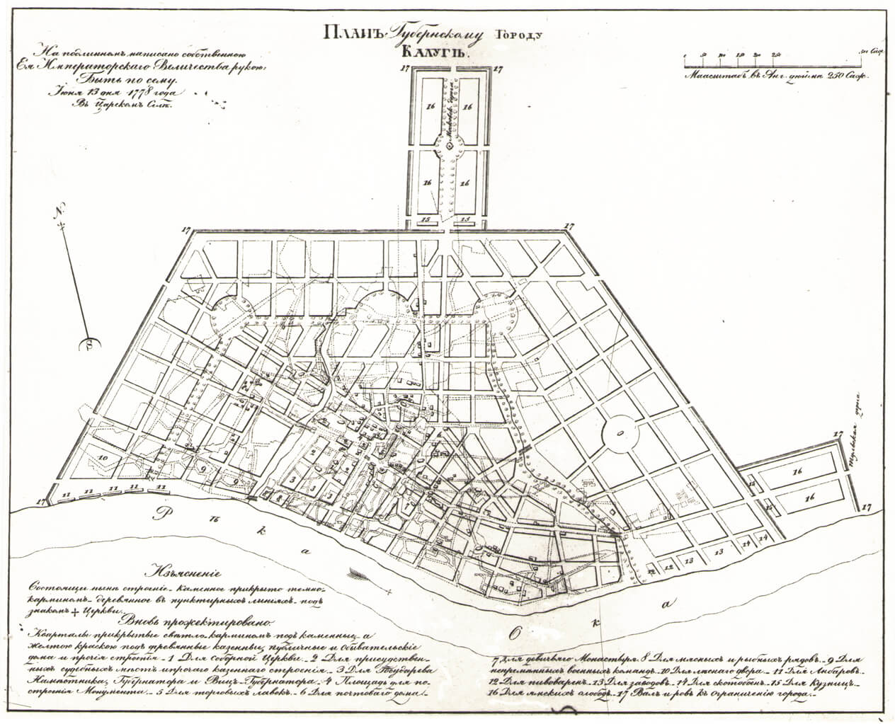
Illus. 48: Classical Kaluga, 1778 (SMA)
")
Illus 49: Bridge over the Berezuiskii Ravine, 1780. Architect P. R. Nikitin (SMA)
")
Illus. 50: Same bridge, detail (Schmidt)
")
Illus. 51: Troitskii Cathedral, late eighteenth century, Architect I. D. Iasnygin (AJS)
")
Illus. 52: Kaluga Market Arcade, c. 1780s–1790s (Schmidt)
")
Illus. 53: Kaluga Zolotarev or Kolotrivoi House, architect unknown, 1805–08 (Schmidt)
")
Illus 54: Kaluga Zolotarev House, central part (SMA)
")
Illus. 55: Kaluga Zolotarev House, side entrance (Schmidt)
")
Illus. 56: Kaluga Chistokletov House, Architect I. D. Iasnygin (Schmidt)
")
Illus. 57: Kaluga City View, 1837 (SMA)
In other instances, Catherine’s urban renewal south of Moscow was shaped by a distinctive feature, their battlements.173 Tsar Vasilii III (1505–33) had not been simply a conqueror but was challenged to defend his conquests. He paid particular attention to Moscow’s southern approach, which was subjected to frequent and destructive raids by steppe successors to the Golden Horde.174 The defensive posture adopted by Moscow had lasting consequences for this borderland, transforming it into a military one of fortified citadels as evidenced by those in Nizhnii Novgorod (1500–11), Tula (1507–20), Kolomna (1525–31), Zaraisk (1528–31), and Kashira (1531).
This line of defense, the so-called Zasechnaia cherta, eventually included fortified monasteries such as the Trinity-Sergius in Zagorsk, which held out against a Polish siege as late as the seventeenth century. While inferior to the Moscow kremlin and its Western European counterparts, these southern fortresses were reasonably sturdy, built usually of brick on a limestone foundation.175 The urban fortresses of Catherinian Kaluga, Kolomna, and Tula are significant here because they were easily recast in a classical mold after their military value no longer mattered.
* * * *

Illus. 58: The Kremlin Walls Ahead
Fortress Kolomna, some sixty miles south of Moscow, enjoyed neither the prosperity of a Kaluga and the northern cities nor the political stature of a Tver’.176 Rather its reputation rested on having been a sixteenth-century outpost against marauding Crimean Tatars. Moscow merchants, who kept a few houses there, engaged in trade with Kaluga and Murom while the town’s industries included leather tanneries, breweries, slaughterhouses, sail-making factories, textile mills, and brick, tile, and pottery works.177 On the eve of its transformation about 1780 Kolomna comprised a “city” and “suburb” with a population of just over 3,000, as well as four adjacent settlements with another 1,600 inhabitants. Although most housing was of wood, numerous masonry churches (twenty-five of Kolomna’s twenty-eight) suggests an economic resurgence of sorts late in the eighteenth century.
After the town was designated a district capital in newly-formed Moscow province in 1781, its authorities were required to submit a general plan for a regulated city which was approved early in 1784. Its geometric lines, like those of early Iaroslavl’, proved problematic, being at odds with the layout of historic ensembles.178 The strategic kremlin, located high over the Moscow River at its confluence with the Kolomenka, had always been the city’s pivot and would inevitably be again, even in a formal plan. The architects were at loss, however, in accommodating the polygon-shaped ramparts with a classical urban design: their straightened streets lacked an axial avenue despite a widened Astrakhanskaia’s approximating one. The planners resolved these matters by making the streets converge obliquely on the plaza and commercial stalls in front of the kremlin. Street placement was further dictated by a second concourse, one leading over the Moscow River to Egor’evsk and Vladimir, although it, too, failed to interface well with the street grid, abutting as it did with the kremlin.
The aesthetic/social dimension figured prominently in Kolomna’s charted future: plazas were projected at both its Moscow and Riazan Gates and as well as at other locations within the city; shops and cafes, moreover, would provide a congenial ambience. Kolomna’s plan did not entail removal of industry to its outskirts; only slaughterhouses were not spared. If Kolomna failed as a successful undertaking in linear planning, its total design was not without merit: inclusion of its monumental kremlin in the new configuration even proved a conspicuous accomplishment.179 Another fire generated another plan, that of 1800, which both refined the work of earlier architects and intensified the pressures for immediate reconstruction.
Unlike the cities discussed previously, Kolomna represented the low end of provincial planning and building: its architecture was hardly distinctive despite bountiful classical trim as evident in the Joanna Bogoslova Bell Tower; nor had the town engaged architects of the stature of Pan’kov, Fursov, Kazakov, or Iasnygin. The Moscow Turnpike, once the habitat of the Zaprudnaia Cossack Settlement, consisted of a guardhouse, small columnar pavilions, monumental columns on pedestals, and obelisks, to name a few. State office buildings were relegated to Astrakhanskaia Street, near the Kolomenka bridge. Warehouses, one of which was masonry, were located just outside the kremlin while the post office, a pharmacy, and police were housed within the citadel walls.180 There were the usual almshouses and churches; the Petropavlovskaia Cemetery and associated church dated from the 1770s; mid- and late-eighteenth-century merchant homes were interspersed along Posadskaia Street. The omnipresent Matvei Kazakov may even have had a hand in designing or rebuilding in 1799 the Voznesenskaia Church.181
")
Illus. 59: Plan of Classical Kolomna, 1784 (PSZRI)
")
Illus. 60: Kolomna Kremlin, 16th century, with market (Schmidt)
")
Illus. 61: Kolomna Ioanna Bogoslova Bell Tower, 18–19th century (Schmidt)
")
Illus. 62: Church of Ioanna Bogoslova (Schmidt)
* * * *
")
Illus. 63: The Development of a Regular Plan for Tula (Lavrov)
Before Catherine’s reign, Tula, unlike Kolomna, had won fame for several reasons.182 Its black soil province acquitted itself as a producer and market for grain and cattle; Tula city, which lay 120 miles south of Moscow, was known for its samovars and iron and small arms for Muscovy’s arsenal.183 Its strategic importance was evidenced by its sturdy brick kremlin, which rose majestically on the banks of the Upa River. Like Kolomna, this fortress had served as a protective barrier against raiders from the south. An early example of Russian citadel architecture, this semicircular yet angular edifice proved adaptable, more than that of Kolomna, to a classical urban plan.184
Although eighteenth-century Tula enjoyed industrial prosperity, expansion engendered its own problems. Sprawl resulting from a population surge in town and suburbs went largely unattended. A 1741 map hints at the challenge awaiting planners a generation later: the kremlin, buttressed by the Upa and Demidovskii Pond to the rear and the Earthen City (Zemlianoi Gorod) wall in front, rested on the Kiev Road axis.185 An armaments factory and more than half a dozen settlements (slobody) lay in disarray beneath the fortress walls.
Although the planners of Catherinian Tula had taken demography and sprawl into account, a fire in 1779 necessitated the city’s reconfiguration.186 The plan drafted later that year imposed a rational design on the city’s web of streets and alleys while preserving its important landmarks. The Commission street plan for Tula was fan-shaped, radiating from the kremlin. While akin to other urban designs, it remained compatible with the city’s historic form and setting, especially its land and water arteries. Further, classical Tula would receive fixed boundaries dividing the town into settlements (posady) and articulating the area beyond the river (zarech’e).
The kremlin as viewed from its river site provided a riveting urban silhouette—the soaring Savior (Spasskaia), Nikitskaia, and Assumption (Uspenskii) Cathedral Towers; the Middle Odoevskie Gates dominating the city center; and the old bastion serving as apex for converging streets. Classical Tula also included an intriguing transportation network: a street encircling the kremlin and connecting with those from Kiev, Moscow, Kaluga, Voronezh, Riazan, and Aleksin.
True to its historic role, this new Kievskaia was projected to form a longitudinal axis with the Assumption bell tower (1772–76) inside the kremlin while pointing toward the Upa River. Further, it would be embellished by two plazas—one at the entrance to the city and another midway along—each accommodating public buildings and shops as well as stately homes. On the opposite side of the river another longitudinal axis, the Moscow Road, was designated. While approximating a kremlin axis, it would converge on a new church rather than the bastion towers. New light industry—beer, meat, and fish stalls—would be relocated to the city’s environs, following in the wake of blacksmith forges and cemeteries which had been moved there in the plague year. The 1779 plan, while hardly revolutionary, was intended to impose order on an otherwise chaotic city. In preserving the fan-shaped contours of the old city the plan hinted at the composition beyond the border articulating the spatial dimensions of the radial thoroughfares which turned toward the kremlin. Once the walls had been pulled down, old roads formerly lost in the wooded maze would magically unveil a grand kremlin prospect.
The Tula plan of 1779, was not, however, realized until the middle of the next century. By then, the All Saints Cemetery Church rested on high ground overlooking the city near the Kiev Gate. Its landmark white bell tower enhanced the lower Kievskaia just as the cathedral had the thoroughfares within the kremlin. In such a way both the Tula citadel and town acquired new form and purpose in Catherine’s and her successors’ classical scheme.
")
Illus. 64: Tula Classical Plan, 1779 (Bunin)
")
Illus. 65: Tula, the Kievskaia, c. 1850 (SMA)
")
Illus. 66: Tula, Late 18th Century Plan (SMA)
* * * *
These detailed classical cityscapes explain Catherine’s expenditure in effort and moneys to upgrade her infrastructure, that is continue the urbanizing that Peter had begun a half century earlier: her Russia had joined or even surpassed European powers by accentuating the razing of the old and planting of new urban structures.187 Success varied, moreover, from renovating Nizhnii Novgorod, Riazan, Voronezh, and Vladimir to founding anew Odessa, Ekaterinoslav, Nikolaev, Aleksandrovsk, and Sevastopol on lands won from the Turks in the 1780s.188 These were in part the administrative centers called for by Catherine in her 1775 gubernii legislation and central to her making the empire more manageable, each entity approximating Enlightenment linear and spatial principles.
Urban centers which failed were often labeled artificial. Nor did planning pristine masonry cities in provincial Russia always proceed smoothly, especially in the hinterlands. There was a plentitude of corruption, obstruction, venality, and not a few public health problems—often abetted by autocracy’s heavy hand. Setbacks notwithstanding, reclusive Muscovy became imperial Russia in short order thereby linking homelands, hinterlands, and newly annexed borderlands. Despite flaws in her planning, Catherine did order and humanize an emergent empire. Her success in furthering imperial governance, brilliant though limited in scope, proved emblematic in making Russia at least superficially “European,” as she had aspired in her Nakaz. The patterned space and lines of town centers revealed more than evolving urban shape and design. Such bound plans affirmed her reign as embodying that union of law and art for which autocrats crave remembrance.
As Wortman noted, Catherine subscribed to the myth of a secular empire, one led by an enlightened monarch and a bureaucratic elite, who brought “the benefits of law and improved life to the new territories as well as the Russian provinces.”189 Enter master town planner, builder, and imperial strategist, William Hastie.
* * * *
VII. Urbanism and Imperial Strategy after Catherine: Alexander I & Hastie
Building and rebuilding Russian cities was just as much an undertaking in the first decades of the nineteenth century as it had been in Catherine’s day….The towering figure in town planning in Russia about 1810 was a Scotsman named William Hastie (Vasilii Ivanovich Geste).190
Vladimir Ivanovich Piliavskii (1958)
Hastie’s drafts, or blueprints, carry great meaning in the history of architecture, filling an existing void in the study of the history of city planning.
E. Chernozubova, “Obraztsovye. proekty planirovki zhilykh kvartalov i ploshchadei nachala XIX v.,”AN, 15 (1963).191 192 [error: two endnotes]
The first third of the nineteenth century witnessed some major changes in the factors that combined to form Russia’s grand strategy.
P. LeDonne, The Grand Strategy Of The Russian Empire.
John LeDonne….makes one of the most pointed cases yet for seeing Russian expansionism as the product of a coherent, systemic plan—a “grand strategy.”
Willard Sunderland 193
In the course of the first half of the nineteenth century the model planning system became more widespread in the Russian Empire than at any other time in world architectural history.194
Dmitrii Shvidkovskii: “Utopia in Neoclassical Garb: Hastie’s Model Planning System.
Dynastic squabbles aside, Russia had fared well by the turn of the nineteenth century. In the life spans of two extraordinary sovereigns, it had evolved from a hermit Muscovite kingdom of considerable size to what was very much a huge European territorial power with a headship of increasing sophistication. In the context of the present narrative, it was a power which had realized or projected cities that manifested a European look and dwarfed anything like it elsewhere on the globe. By the end of Catherine II’s reign, the composition and complexion of provincial towns were changing: Mironov tallied 673 rural settlements that had acquired urban status of sorts. As Shvidkovskii observed in this paper’s introduction late Catherinian rural Russia—checkered with villages, estates, and even towns—evidenced this change. Of course, such verbiage could be deceptive: “Massive and rapid urbanization,” as historian Blackwell warned did not really occur until the end of the nineteenth century with “the emergence of the modern Russian city.”195
Despite the Emperor Paul I’s antagonism toward his mother, his reign (1796–1801) was not one of withdrawal from the urban scene. His utilizing the building apparatus of the Second Expedition of the Ministry of Internal Affairs and retention of Catherinian architects evidenced continuity and even harmony with the European neoclassical tide. Yet it was Alexander I (1801–25), Catherine’s visionary grandson, whose planning apparatus best represented this continuity with Catherine’s classical urbanism. Moreover, Alexander in an edict of 10 August 1810 carried ministerial centralization still further by placing the Second Expedition under police authority; architecture and construction remained in the department of state economy (gosudarstvennoe khoziaistvo) and public buildings in the Ministry of Internal Affairs as clarified in subsequent decrees.196
From the beginning of his reign Alexander had relied on the Scots architect Hastie who had famously personified a linkage with Catherine’s classical urbanism.197 Hastie, who had arrived in Russia early in the 1780s as a stone mason under Charles Cameron, established himself as architect to three generations of sovereigns—Catherine, son Paul, and especially grandsons Alexander and Nicholas. Having experimented successfully with royal Tsarskoe Selo, Hastie was named chief architect in 1808, winning recognition as the architect capable of realizing Alexander’s vision for urbanizing provincial Russia. In 1811, Alexander appointed Hastie effectively arbiter of urban planning for empire. For more than two decades he was attached to the ministry of police, routinely receiving from provincial heads (nachal’niki) town plans which he altered, approved, or rejected.198
The artistry and virtuosity of Hastie and architect Stasov during these years was evidenced also by their urban design albums, circulated from 1811. Constituting a model planning system for empire, they proved a reliable guide for builders—whether of residences, bridges, post stations, or even garden fences, indeed, for every conceivable space—estates, plazas, and street frontages. Each was always in accord with the tenets of reguliarnost;199 Hastie and Stasov, moreover, effectively employed model plans to urban development and imperial expansion in remote regions where architects were a rarity.
Hastie also merits recognition here beyond his work on model plans for dwellings. That in his 1811 album he emphasized model plans for blocks and squares is especially germane to this paper’s central purpose, that of articulating the shaping of Russia’s cities, especially Catherinian ones. His developing four separate groups of blueprints for plazas: a three-sided” or triangular one; a four-sided one, including eight rectangular blocks and two squares; one of circular blocks, suitable in radial ring plan; and, finally, one of blueprints for multisided blocks and a six-sided squares. These led historian Chernozubova to elevate Hastie to a pinnacle of world class town planners.200
* * * *
Model Plans: Empire and Global Neoclassicism
Although model projects had a role during Catherine’s and even Peter’s reigns, their apogee occurred in the interim between Hastie’s publishing his album in 1811 and his death in 1832. During these years many newly minted city plans were approved by Master Hastie himself. After endorsing a classical Viatka (1811), he approved classical plans for Saratov (1812), Smolensk (1815), Ekaterinoslav (1817), Ufa (1819), Tomsk (1824), and Omsk (1829).201 These actions, which called for a special commission of the Ministry of Internal affairs to process urban plans and model designs, were indicative both of Hastie’s managerial skills and the impact which Russian urbanism had on global neoclassicism. Not only were Hastie’s and Stasov’s albums central in making Alexander I’s provincial schemes a reality, but this spate of city plans also suggests that Hastie was master in the formulation of imperial Russia’s grand strategy during these crucial years.
Having Hastie at hand, Alexander committed himself to an urban and imperial policy reminiscent of Catherine’s; like her, he traveled the empire. In 1824, the year before his death, he had journeyed to Orenburg and even Perm in western Siberia to inspect mines, factories, and garrisons.202 From 1825 Hastie offered his services to the new Tsar Nicholas.
VIII. Conclusion: Two Versions of Neoclassicism, the 20th Century Revival
The origin of modern city planning in Russia is cloaked in paradox. Though looking to the future, it was brought into being by people preoccupied with the past; though revolutionary in aim, it sought…to preserve the architectural legacy of the monarchy in its most resplendent phase, the eighteenth century.203
Frederick Starr, “The Revival …of Urban Planning….”
The ideological premises attributed to pre-revolutionary Neoclassicism—nostalgia for the past glory of the ancien regime and a distaste for innovation in aesthetic values—stood in contradiction to the demands of the capitalist system that supported major construction projects in Petersburg and Moscow.204
William C. Brumfield, “Anti-Modernism and the Neoclassical Revival…1906–1916”
Even after Alexander and Hastie had brought closure to post-Catherinian classicism, a revival and even resurgence won recognition and acceptance early in the next century. Although that phenomenon is beyond the scope of this paper, the importance assigned to it by Starr and Brumfield in their provocative and strikingly different interpretations make it germane in a conclusion to this neoclassicism narrative.205
That Catherine II founded classical cities or reshaped existing ones in a provincial wilderness—no less than her embellishing St. Petersburg and even Moscow immortalized her alongside Antiquity’s Vitruvius and Renaissance masters like Alberti and Vignola. She energized anew the architectural sculpting of old Russia in accord with the Enlightened canons of order and reason as well as style.206 The empress shared with enlightened thinkers the conviction that city planning was not “merely a technical undertaking but [one which] should in the truest and most elevated sense be an object of art.207 The City as a Work of Art in the Russian environment is quite as breath-taking as the nineteenth-century endeavors of John Nash’s surgical cut of Regent Street in London, Haussmann’s unsparing alteration of old Paris, or the laying out of the Ringstrasse in Vienna.208
Although Catherine’s and Alexander’s urban shaping of provincial Russia was undertaken principally to effect efficient management of Russia’s imperial space, the backstory here—that of imposing a classical footprint on undeveloped space—assumed hardly less importance. Provincial Russia’s neoclassicism, even more than that of embellishing Petersburg or Moscow, won recognition in the realm of global building culture. The notion of making Russia European was, arguably, the most ambitious undertaking of that neoclassical age. It surpassed that of the more publicized achievements in Berlin, Munich, Liverpool, Boston, McKim, Mead, and White’s New York, Burnham’s Chicago, and the Federal Triangle of New Deal Washington, DC.209 Add to these the classical reworking of such colonial cities as “Pearl of the Orient” Manila; the Raj cities of British India, New Spain in America; Hanoi in French Indo-China, and cities of Francophone Africa—all of which paled before the classical stamp of Russian urbanism.210
How does one account for this renewed interest in eighteenth-century urban Russia? In part, it appears derived from Soviet patriotism, an infatuation with classical architecture during and after World War II. History has romanticized and stretched the notion of parallel images of the military successes of imperial Petersburg and 1812 Moscow and those of the Red Army in World War II; moreover, comparisons were drawn between Soviet and Catherinian urbanizing their respective hinterlands.211 The spate of recent (and generally favorable) Catherine biographies recounted her keen intellect, deftness in people relationships, sound political instincts,212 and aesthetic pursuits—all of which evoked admiration.213
A fitting conclusion lay in a coalescing of the various themes embedded in this narrative. First, is one of Russia and Space, or better said, Russia’s management and shaping of its space. This conclusion further points to the crucial role which its cities played in governance. That a spatial void was in part filled by an urban undertaking—not just by the founding of administrative centers but by renovating existing ones—was of paramount importance in the kind of state Russia would become and the impact that it would have on Europe and Europe on it.
A second theme is that of classicism as ideology. Provincial Russia had long harbored a reputation as a reservoir for backwardness, even boorishness. While “Backward Russia” did not suddenly and miraculously disappear with Catherine and her cities, her distinctive urban centers did advertise with their Western aesthetic a new imperial Russia. The classical cities that had sprung up in provincial Russia could and did claim a commonality with Europe. It took and a Peter I and a Catherine II to make this happen: the classical cities which they, and especially Catherine, planned or altered in central Russia became emblematic of their achievement.
Classicism’s true significance was more than just applying an architectural label. Rather the term harkened to its Roman roots of empire and even hegemony. It signified order in a very disordered land bringing even a modicum of cheer with its painted facades and glistening columns. In liberating wooden Muscovy from the clutter of courtyards and picket fences this ordered metropole with its law and imperial aesthetic was projected to offer Russians benefits similar to those which empire had to their Roman forebears. In the Russian imperium as in the Roman one the city fostered an imperial strategy. That this should occur precisely when the Empress Catherine pursued classical urbanism under the authoritarian mantel of a European territorial state was hardly coincidental: Roman law of empire provided a model for the imperial bonding which Catherine required for cohesive governance. Provincial cities managed by a master strategist like William Hastie set imperial Russia on a new course for the new century. The epilogue which follows surveys this provincial phenomenon through its historians.
IX. Epilogue: Catherine & her Successors—Provincial Urbanism & Its Historians
If Catherine and her contemporaries took exaggerated pride in her programme, later historians more than compensated by treating the programme with exaggerated scorn….They emphasized Ekaterinoslav but forgot Odessa, cited the new towns that failed to grow and develop but forgot those that succeeded.214
Robert E. Jones
While the present narrative focuses on Kostof’s kind of planned city, it also looks at how Russians have treated urban history, especially that of the eighteenth and early nineteenth centuries. For this reason, an examination of Samuel Baron’s review article “The Town in ‘Feudal’ Russia,” is warranted.215 Although dated, Baron’s work is an excellent introduction to the field. After Baron and foremost in the literature of Russian town planning is Polnoe Sobranie Zakonov Rossiiskoi Imperii (or PSZRI (St. Petersburg, 1839). This work on the laws of the empire contains city plans completed during the reigns from Catherine II through Nicholas I.
Igor Grabar’,V. A. Shkvarikov, and A. V. Bunin, pioneered Soviet historiography of eighteenth-century Russian town planning and building. Grabar’s eight-volume work (1950s & 1960s), while a nominal revision of his pre-Revolutionary Istoriia russkogo iskusstva, was more than that. This milestone, buttressed by bibliography, diagrams, maps, and illustrations, introduced many younger historians to the field and focused more on urban/provincial history than did the original work. Shkvarikov’s Planirovka gorodov rossii XVIII I nachala XIX veka (1939), followed by his more detailed Ocherk istorii planirovki i zastroiki russkikh gorodov (1954), became standard along with Bunin’s classic Istoriia gradostroitel’nogo iskusstva (Moscow, 1953). Although highly ideological and spanning more than Russia, the latter proved a major publishing venture.
Among classic town planning works that also appeared in the 1950s–90s, P. A. Sytin’s two–volume Istoriia planirovki i zastroiki Moskvy (1950, 1954) and S. A. Zombe’s “Proekt plana Moskvy 1775 goda i ego gradostroitel’noe znachenie,” Ezhegodnik instituta istorii iskusstv 1960, (Moscow, 1961), 55–96, deserve mention for setting the standard. The provincial scene was notably treated by Zombe, A. N. Petrov, and T. M. Sytina’s “Gradostroitel’stvo” in Grabar’, Istoriia russskogo iskusstva 6 (1961), 236-77; and T. M. Sytina, “Arkhitektura russkoi provintsii” in Grabar’ Istoriia., VI, 278–95 & VIII, 243–69. At the end of the Soviet period T. F. Savarenskaia, D. O. Shvidkovskii, and F. A. Petrov, Istoriia gradostroitel’nogo iskusstva pozdnii feodal’ism i kapitalizm (1989) have won deserved recognition although only two chapters treat the eighteenth and early nineteenth centuries. A. N. Petrov’s article on architect I. E. Starov in Grabar’ 6, 6 (1961), 166–85 (p. 184).
X. Lens for Viewing Russia’s Classical Urbanism
Evolution of urban shapes was of the sort propounded by Spiro Kosof in his The City Shaped, Urban Patterns and Meanings Through History, and the French urbanist Pierre Lavedan. noted below.216 There were others as well.
A. Vitalii Alekseevich Lavrov—Developing regular plans as in Razvitie Planirovochnoi Struktury.
Considerable clarity was achieved in this paper from the graphics of Soviet architect/historian Vitalii Alekseevich Lavrov (1902–89), who articulated stages of development in central Russian cities, which included Iaroslavl’, Kostroma, Tver’, Kaluga, and Tula treated below. 217 To this list Lavrov added Odessa, Kazan’, Smolensk, Riazan,218Vladimir, Nizhnii Novgorod. and Ekaterinoslav. Lavrov’s graphics focused on these cities from the seventeenth-century, their pre-urban status, to publication of their plans in Polnoe Sobranie Zakonov Rossiiskoi Imperii in 1839. Each plan typically appears under the caption “Illus.+ Development of the Regular Plan of … (Lavrov).”
B. A. V. Shchusev Museum of Architecture (SMA), Moscow—detailed plans were made available by the late Viktor Baldin, Director, and staff.
C. Polnoe Sobranie Zakonov Rossiiskoi Imperii (PSZRI), Complete Collection of the of the Russian Empire (1839).
The PSZRI is in two editions, the Imperial and the Regular; the difference between the two is one of quality rather than substance. The Imperial edition, most likely the single copy for the Imperial Library, was printed on heavy paper and bound in “full green Russian leather” with the Imperial Coats of Arms tooled on its front—the distinct Imperial Eagles each of Alexander I, Nicholas I, and Alexander II. The city plans in it are colored by hand in watercolors The Imperial edition likely was for the Imperial Library. The city plans, photographed and illustrated in this paper, were those detailed in a second volume of this Regular edition entitled Book of Drawings and Sketches (Kniga chertezhey i risunkov) in the Bayerische Staats Bibliothek in Munich.
D. Georgii Lukomskii & the Architecture of Provincial Russia (see below).
Lukomskii’s Architektura Russkoi Provintsii (1916), possibly available only in the Lenin Library in Moscow, is a treasure trove of photos and text of now vanished classical buildings. While Lavrov’s methodology transformed reportage of the face of urban Russia from a static to a dynamic one, Lukomskii, focused on the architectural diversity within provincial cities, among them Orel, Kaluga, Smolensk, Tula, Iaroslavl’ , Kostroma, Vladimir, Nizhnii Novgorod, Pskov, Novgorod, Tambov, Voronezh, Kursk, Vologda, [and] Chernigov—some of which are detailed below.219 Lukomskii’s classical showcase was a visual and verbal portrait of highlighting the following:
Roman Catholic and Protestant churches, monasteries, cathedrals (Sobors), belfries,18th and 19th-century churches, chapels, governors’ palaces, archbishops’ houses, office or bureau buildings, guard-houses, officers’ meeting places, barracks, riding school, arsenals and store rooms, prisons, turnpike post stations and bridges; houses of nobility; theatres; diverse kinds of schools; city halls and consistories; stock markets and hotels; market houses and warehouses, fire stations, hospitals, alms-houses and asylums, window decorations, vagrant houses, arches of triumph and city entrances; obelisks, pyramids, and columns crowned with eagles, coats of arms, inscriptions and pedestals; temples and wide stairways, summerhouses; friezes and garlands; rotundas, fountains, pergolas; chapels, mausoleums and funeral monuments; private buildings; apartment buildings; governor’s houses; houses with semicircular corners and balustrades; wooden buildings; suburban and estate houses, pavilions; village summer houses, and windmills.220
Lukomskii’s visual feast introduces the centerpiece of the present essay—the detailing of nine Catherinian and post-Catherinian Russian Interior cities—Arkhangel’sk and Vologda in the north; Iaroslavl’, Kostroma and Tver’/Torzhok on the Volga (which Catherine had visited in 1767); and Kolomna, Tula, and Kaluga, strategic outposts which had once secured Muscovy’s southern approach.
* * * *
XI. Seven historians of classical urbanism in provincial Russia
- Robert E. Jones, Professor Emeritus of History, at the University of Massachusetts, Amherst, where he taught from 1968 to 2007, has written books and articles that have provided a context for the substance of the present paper. They include The Emancipation of the Russian Nobility (1973). Provincial Development in Russia: Catherine II and Jacob Sievers (1984), and Bread Upon the Waters: The St. Petersburg Grain Trade and the Russian Economy 1703–1811 (2013). Especially germane to the present paper is his seminal “Urban Planning and the Development of Provincial Towns in Russia, 1762–1796,” ed. J. G. Garrard (Oxford, 1950), 321–44.
- Georgii Kreskentevich Lukomskii (1884–1954) was born in Kaluga and educated at the Kazan Art School in the first years of the twentieth century and afterwards at the Imperial Academy of Fine Arts in St. Petersburg. He won recognition as a painter, art historian, and critic. Above all, he was a prolific writer and defender of aristocratic ways; in architecture, especially that of Palladio in Russia. As noted, his profusely illustrated Arkhitektura russkoi provintsii (1916) is an invaluable resource, as evident in the present narrative, for the diversity of classical edifices built (though often not surviving) in post-Catherinian Russia. Lukomskii left Russia after the Revolution to work in the West.
- As noted previously, the late architect /historian Vitalii Alekseevich Lavrov (1902–89) authored “Pereustroistvo planirovochnoi struktury gorodov na regularnoi osnove” and “Pereustroistvo tsentrov gorodov po reguliarnym planum” in Razvitie planirovochnoi struktury istoricheski sloshivshikhsia gorodov (1977). In his studies, indispensable for a thorough treatment of Catherinian urbanism, Lavrov introduced a developmental dimension—that of diagraming stages of construction—into the urban history of eighteenth-century Russia. That this methodology enabled Lavrov to stress the evolution of city centers, plazas, streets, and blocks so critically important in showing the dynamism of the new classical look at the eighteenth-century Russian city. The variants of the evolution of the Ekaterinoslav center illustrated here capture this progression.
- The late Nikolai Feodosevich Gulianitskii was one of the most serious scholars treating the shape of Russian classical cities. Characteristic of his expertise was his article on city centers—“Cherty preemstvennosti v kompozitsii tsentrov russkikh gorodov, pereplannirovannykh v XVIII v.” AN 29 (1981), 3–17. His lavish two-volume Petersburg i drugue novye rossiiskie goroda XVIII–pervoi poloviny XIX vekov (Moscow, 1995) contains articles on New Cities Based on Regular Principles; further, his Moskva i slozhivshiesia russkie goroda XVIII–pervoi poloviny XIX vekov (1998), similarly elegant, treats diverse aspects of Kazan’, Nizhnii Novgorod, Voronezh, Riazan, Astrakhan, and Irkutsk in ten separate articles. The articles in Part 3, pp. 177–260, pertain to Pereplanirovka i rekonstruktsiia slozhivshikhsia gorodov, and in Part 4, pp. 261–410, to Pereplanirovannye goroda osobennosti struktur, tsentrov, ansamblei. These works, besides being profusely illustrated (often in color), are embellished with city plans, maps, city views, architectural drawings, and bibliography.
- One of the most versatile, prolific, and, indeed underrated historians of the architecture of classicism, Vladimir Ivanovich Piliavskii (1910–84) of the Leningrad Engineering and Building Institute published in diverse genres—architectural histories of Russia and Leningrad/ St. Petersburg, Ukraine; editing a notable work by A. I. Osiatinskii on the Volga cities of Astrakhan, Saratov, Samara, Tsaritsyna (Stalingrad, Volgagrad), Simbirsk; biographies of Rossi, Quarenghi, and V. P, Stasov; detailing Hastie’s and Stasov’s work on model projects, applying for illustrative purposes the town and architectural plans of Hastie, Stasov, and L. I. Ruska thereby confirming Hastie, especially, at once, as both the tsar’s master urban planner and imperial strategist. Further, Piliavskii detailed the steps for approving clasical town plans, e.g. the consideration given terrain, the roles of the land surveyor and provincial architect in its drafting—all of which revealed the centralization of the planning process and signified the author’s own concern with its practicalities. Then, too, he authored Natsional’ osobennosti (National Peculiarities of) russkoi arkhitektury (Leningrad, 1974),which focused on diverse Russian architectural styles—among them baroque, classical, Palladian—as evidenced in the book’s illustrations, which are a mine of period architectural paintings.
- Currently considered “Russia’s leading architectural historian,” Dmitrii O. Shvidkovskii is widely published in English as well as Russian. Such publications include Empress and the Architect: British Architecture and Gardens at the Court of Catherine the Great (1996), ‘Classical Edinburgh and Russian Town Planning of the Late 18th and Early 19th Centuries: The Role of William Hastie, 1755–1832′ in “Scottish Architects Abroad” in Architectural Heritage, “Catherine the Great’s Field of Dreams: Architecture and Landscape in the Russian Enlightenment” in James Cracraft and David Rowland, eds., Architectures of Russian Identity 1500 to the Present (Ithaca, 2003), pp. 51–65. bolsters Shvidkovskii’s claim to originality in citing an historic interaction between Russian and Western architecture (Russian Architecture/ West) and therefore a striking reversal of standard Soviet/Russian claims: even before 1914 none other than I. E. Grabar’ discerned French influence prevalent in Russia’s classicism.221
- The impact of William C. Brumfield on both Russian architectural history and urban planning has been unparalleled. Aside from his monumental History of Russian Architecture, (1993, 2004), as noted, he has been a prodigious traveler throughout Russia, a photographer and publicist of historic edifices and their landscapes, and a tireless advocate for their preservation. His photos—especially of provincial architecture and townscapes—have transformed the field for both Russian and Western scholars. Brumfield has also written about revival classicism in the twentieth century as evidenced by The Origins of Modernism in Russian Architecture (Berkeley, CA, 1994); “Anti-Modernism and the Neoclassical Revival in Russian Architecture, 1906–1916,” JSAH, XLVIII: 371–386 (1989); and Neoclassical Aestheticism in Pre-revolutionary Russian Architecture” in John O. Norman, ed., New Perspectives on Russian & Soviet Artistic Culture (New York, 1994), pp. 41–53.
The Kennan Institute for Advanced Russian Studies in Washington, DC has regularly illustrated its publications with Brumfield’s architectural photos, while the National Gallery Library serves as their repository. The Russians have recognized him with membership in the Russian Academy of Architecture and Constructive Sciences. His Landmarks of Russian Architecture: A Photographic Survey (Amsterdam, 1997) is a classic of its kind. Additionally, he has edited in Russian/English since 1905 the series Discovering Russia: Architectural Heritage in Photographs, which includes works on Usolye, Irkutsk, Tobol’sk, Torzhok, Totma, Kolomna. and most recently on Smolensk. Besides filling visual and scholarly gaps, he has published on line since 2010 a popular series entitled “Russia Beyond the Headlines” which includes short pieces on the architecture of such provincial cities as Tula, Torzhok, Tobolsk, Omsk, Kaluga, Kolomna, Riazan, Iaroslavl, Vologda, Irkutsk, Tomsk, Perm, and Veliky Ustiug. His 1990s publications explore a later Russian classicism, that of the twentieth century, while his very recent study (2015) continues the provincial narrative with that of the Russian North.222
* * * *
XII. Select Recent Works on Eighteenth-Century Provincial Russia
Of the relatively large number of works in English on or impinge upon Catherinian urbanism the following merit consideration: Hans Blumenfeld, “Russian City Planning of the Eighteenth and Early Nineteenth Centuries,” Journal of the Society of Architectural Historians, 4 (1944), 22–33; J. M. Hittle, The Service City (Cambridge, Mass., 1979); Michael F. Hamm, ed., The City in Russian History (Lexington KY, 1976)—which contains useful though dated articles by J. M. Hittle (the eighteenth century city); Gilbert Rozman (comparative urbanization, 1750–1850), Frederick Skinner on the building of Odessa. S. Frederick Starr on “The Revival and Schism of Urban Planning” and William L. Blackwell on “Modernization and Urbanization in Russia.”
Notable among contemporary Russian scholars who publish in both Russian and English about Russian urbanism is Boris Mironov, who has provided new insights on Russia’s demography and economic history.223 Particularly relevant to this paper are his studies of urban history and his article on Russia’s price revolution, as translated and cited above. Anthony Cross has pioneered aspects of the British in Russia, including architecture, in his By the Banks of the Neva: Chapters from the Lives and Careers of the British in Eighteenth Century Russia (Cambridge, 1997) Albert J. Schmidt drew on Vladimir Ivanovich Piliavskii’s work to introduce “William Hastie, Scottish Planner of Russian Cities,” Proceedings of American Philosophical Society 114, no. 3 (1970), 226–43 and in Hastie”s albums of model designs for houses and bridges—“Hastie and his Albums: Publicizing and Imposing Architectural Style in Catherinian and Alexandrian Russia, Proceedings of the of the American Philosophical Society 145, no. 2 (June 1999). 208–32, and Alexander M. Martin for treating Catherine’s imperial Moscow in his Enlightened Metropolis: Constructing Imperial Moscow, 1762–1855 (Oxford, 2013).
A. Provincial Administration
Western scholarship has been extraordinarily productive regarding aspects of eighteenth-century Russian governance and expansion, touching as it frequently does on the relationship between Catherine’s imperialism and her urbanism.224 The present narrative has, as stated, drawn on the scholarship of Robert E. Jones, John P. LeDonne, Willard Sunderland, Dominic Lieven, among others.225 Jones’s on provincial administration and city planning is an excellent context for more detailed urban study.226 LeDonne’s Grand Strategy of the Russian Empire, 1650–1831 and articles in Cahiers. du Monde Russe et Sovietique, subsequently incorporated in his books, are especially germane.227
The works of Dominic Lieven—notably Empire: The Russian Empire and Its Rivals (2002) —and Sunderland, Jane Burbank, Mark von Hagen, and Mark Bassin on Russian imperial space and territoriality offer a new dimensions in treating Catherine’s urbanism beyond the now dated one by Jones.228 Sunderland’s seminal “Imperial Space :Territorial Thought and Practice in the Eighteenth Century,” in Jane Burbank, Mark von Hagen, & Anatolyi Remnev, Russian Empire: Space, People, Power, 1700–1930 (Bloomington, IN 2007), 33–66, is central to this paper. The most recent on empire is Serhii Plokhy’s Lost Kingdom: The Quest for Empire and the making of the Russian Nation, from 1470 to the Present.
Works on Russian demography and economic history like Arcadius Kahan’s The Plow the Hammer and the Knout: An Economic History of Eighteenth-Century Russia (Chicago, 1985) and Ian Blanchard’s Russia’s “Age of Silver”: Precious-Metal Production and Economic Growth in the Eighteenth Century (1989) are germane to the notion of financing empire. Paul Dukes, Catherine the Great and the Russian Nobility (1967) sets a standard for that subject.
B. Recent biographers of Catherine the Great
Especially that by the late Isabel de Madariaga and those by John Alexander, Simon Dixon, David Griffiths, David Ransel, Alexander Martin, and Katia Dianina—offer varied perspectives of Catherine, possibly her cities, and her enlightened mentalité. V. F. Levinson-Lessing’s Istoriia kartinnoi galerei Ermitazha (Leningrad, 1985), which treats Catherine as energetic collector of paintings, offers a fascinating parallel to Catherine as energetic founder of cities.
C. Town Planning and Its Architects
N. Belekhov’s book-length Ivan Starov (Moscow, 1950), pp. 133–57 treats Starov’s town planning in south Russia. Finally, two works on single cities—M. A. Il’in, Riazan (Moscow, 1954), and A. I. Suslov and S. S. Churakov’s Iaroslavl’ ( Moscow, 1960) set the standard when published.229 Others deserving mention are I. A. Bondarenko and S. M. Shumulkin, “Istoricheskii put’ razvitiia Nizhnego Novgoroda,” Arkhitekturnoe nasledsvo (hereafter AN), 35 (1987–88), 3–13, especially pp. 10 & 12.; N. A. Evsina, “Ansambl’ kazanskogo univesiteta,” Ezhgodnik instituta istorii iskusstv’, Arkhitektura i zhivopis’ (Moscow, 1961) and “Zdaniia kazanskogo universiteta,” Pamiatniki kul’tury 4 (1963), 107–27. A. I. Osiatinskii”s rare Stroitel’stvo gorodov na Volge (Saratov, 1965), as noted, captures the look and character of the Volga cities—Samara, Saratov, Tsaritsyn, Simbirsk, and Astrakhan—through its maps and plans as well as text. See also S. S. Ozhegov, Tipovoe i povtornoe stroitel’stvo v Rossii v XVIII–XIX vekakh (Moscow, 1983), pp. 58–78, for Smolensk, Ufa, and Tula.
Two series of Soviet booklets on Individual Cities
Sokrovishcha Russkogo Zodchestva or Sokrovishch Zodchestva Narodov SSSR—(1940s) and Arkhitektura Gorodov SSSR (1950–60s), have treated, however unevenly, both architecture and planning, often with an eighteenth-century focus. Replete with photographs, maps, diagrams, and bibliography, these works often have proved useful in the writing of this paper. An earlier series included V. Ivanov’s Iaroslavl’ (1946); S. Agafonov’s Gor’kii/Nizhnii Novgorod (1947); and A. Kiparisova’s Tula (1948); in the second A. I. Popov’s Tomsk (1959); N. V. Troitskii’s. Voronezh (1959); P. A. Tel’tevskii’s Velikii Ustiug (1960); and M. V. Fekhner’s Kaluga (1961) and Kolomna (1966).
The best periodical for Russian town planning and architecture is Arkhitekturnoe nasledstvo, cited as AN (1951–2014 ).230 See also T. S. Proskuriakova,“O reguliarnoste v russkom gradostroitel’stve XVII–XVIII vv (1980), “Opreemstvennosti v russkom gradostroitel’stve vtoroi poloviny XVIII v” (1985) and G. Ia. Mokeev, “Tipologiia Drevnerusskikh gorodov” in AN 25 (1976), 3–11. typify such articles. V. A. Lavrov, mentioned above, published from the late 1940s to the late 1970s—his “Tvorcheskie uroki russkogo gradostroitel’stva,” Arkhitektura i stroitel’stvo, no. 10 (1949); and “Tipovye proekty v zastroike tsentrov russkikh gorodov vtoroi poloviny XVIII veka,” in Arkhitektura SSSR, no. 7 (1956), which were characteristic of his work and signified the importance of these two journals.
There has been noteworthy scholarship on cities beyond European Russia. F. Ia. Polianskii, Gorodskoe remeslo i manufaktura v Rossii XVIII v. (Moscow, 1960) has focused on early regional factory building. R. M. Lotareva’s, Goroda-Zavody Rossii XVIII–pervaia polovina XIX veka (Ekaterinburg, 2011) is the most recent and excellent work on the industrial Urals. See online for additional Lotareva publications. S. Alferov is also well regarded for his studies of Ural factory architecture and towns. His Zodchie starogo Urala: pervaia polovina XIX veka (Sverdlovsk, 1960), doctoral dissertation Zarozhdenie i razvitie iotechestvennoi promyshlennoi arkhitektury na Urale (1960), and the drawings, diagrams, and photographs in both speak to this matter; finally, see Alferov’s “Iz istorii promyshlennoi arkhitektury no Urale XVIII i pervoi poloviny XIX vekov,” Arkhitektura SSSR, 2 (1952); ______, ”Tvorchestvo russkikh arkhitektorov no ural’skikh zavodakh (XVIII v. i pervaia polovina XIX v.)” in Trudy ural’skogo politekhnicheskogo instituta im. S. M. Kirova, sb. 40, str. 171–198; ______, Zarozhdenie i razvitie otechestvennoi promyshlennoi arkhitektury na Urale (Sverdlovsk, 1962); ________, Zodchie starogo Urala: pervaia polovina XIX veka (Sverdlovsk, 1960). For the southern Urals see also E. V. Ponomarenko’s monograph (2012) on the architecture and urban planning of that region. For Ural masonry architecture see A. Iu. Kaptikov, Kamennoe zodchestvo russkogo severa viatki urala XVIII v (Sverdlovsk, 1990).
Important works on Altai industrial towns, especially those by Yelin Vvyacheslavovna Stepanskaia and Tamara Mihajlovna Stepanskaia and on Altai town architects connected with the Demidov metallurgical establishment include T. M. Stepanskaia, “The Altai’s Industrial Architecture of the 18th–19th Centuries,” Middle East Journal of Scientific Research 14, 2 (2013), 263–266; and Y. V. and Vladislav Vladimirovich Stepanskiy, “The Activities of Students of the Russian Academy of Fine Arts in the Altai in the End of the XVIII—First Half of the XIX Century,” Ibid, 15 (1, 2013) 27–31. Note, too, […] Gorbachev, T. T. Stepanskaia, and V. Tsarev, Town planning of Siberia of the XVIII–XX centuries (2011), which I have not seen. See online references to Demidov Square in Barnaul in the Altai and A. M. Pribykova, “Pervye metalurgicheskie zavody po Altai,” A.N. 15 (1963), 121–44. Other works on planning distant from Moscow and St. Petersburg include A. Iu. Kaptikov, Kamennoe zodchestvo russkogo severa, Viatki i Urala XVIII v. problema regional’nykh shkol (Sverdlovsk, 1990); V. V. Kirillov, “Sibirskii prikaz i ego rol’ v organizovannom stroitel’stve gorodov na novykh zemliakh,” AN 28 (1980), 13–19; N. L. Krasheninnikova, “Oblik russkogo goroda XVIII v. na primere Orenburga, AN , 24 (1976), 72–75; “Voprosy planirovki gorodov orenburgskoi linii (no premere g. Troitska) AN, 27 (1979), 140–46.
See also I. Kushnir, “Rabota Arkhitektora P. R. Nikitina v Novgorode”, AN, 7 (1955), 140–42; M. B. Mikhailova, “Osnovye etapy formirovaniia Kerchi v XVIII–XIX vv.” AN, 25 (1976), 50–56; “Osobennosti gradostroitel’nogo razvitiia iuga Rossii (konets XVIII–pervaia polovina XIX v.),” AN, 27 (1979), 49–57 and “Aleksandr Digbi—zodchii klassitsizma iuga Rossii,” AN, 28 (1980), 80–82; B. I. Ogly, “Arkhitek-turnye pamiatniki Irkutska XVIII–nachala XIX v.” AN 27 (1979), 161–69; V. I. Piliavskii, “Iz istorii planirovkii zastroiki Kieva v nachale XIX v.” in M. P. Tsapenko, et al., Zodchestvo Ukrainy (Kiev, 1954), pp. 197–212; A. M. Pribytkova, “Dereviannoe zodchestvo Tomska”, AN, 5 (1955), 101–14 and ; T.S. Proskuriakova, “Cherty svoeobraziia arkhitektury Sibiri XVIII v.,” [Tobolsk and Tiumen”] AN. 40 (1996), 70–74 and “K Khrakteristike monumental’noi arkhitektury zapadnoi Sibiri XVII–XVIII v.,” AN, 35 (1987–88), 53–63; and “Planirovochnye kompozitsii gorodov/krepostei Sibiri (vtoroi poloviny XVII–60-e g., XVIII v), AN 25 (1976), 57–71; P. G. Ryndzyunskii, “Novye goroda Rossii kontsa XVIII v” in Problemy obshchestvenno-politicheskoi istorii Rossii i slavianskikh stran (Moscow, 1963); I. N. Sliun’kova, “Osobennosti gradostroitel’nogo razvitiia Dinaburga [Dvinsk] in AN 40 (1996), 83–91 [cf. plans of 1785 and 1811 and work of architect A. E. Shtaubert].
See, notably, T. M. Sytina, “Iuzhno russkie goroda pervoi chetverti XVIII veka” in Tat’iana V. Alekseeva, ed. Russkoe iskusstvo XVIII veka (Moscow, 1968); V. V. Vecherskii, “Gradostroitel’noe razvitie Poltavy v XVII–XVIII vv” AN, 39 (1992), 139–47; and Aleksandra Georgievna Vvedenskaia, Iz istorii planirovki russkoi derevni i radochego poselka na Urale XVIII veka i pervoi poloviny XIX veka (Dissertation in Lenin Library, Moscow, 1949).
Add to this list James Cracraft’s impressive volume on Petrine Revolution in Russian Imagery (1997), which touches on the intersection of provincial urbanism with the eighteenth-century craze for print images of townscapes and plans, architectural drawings, and, especially, cartography. Regarding the latter, see Steven Seegel ‘s recent Mapping Europe’s Borderlands: Russian Cartography in the Age of Empire (2012) is essential for study of Russian urban and imperial space. One reviewer’s has noted the “breathtaking” scope of the book—one of tracing “the contested histories of power and territory from the rise of Enlightenment cartography [and], the rationalization of an imperial Russia.”231
Excepting church destruction during the Khrushchev era, the initial Soviet practice of willful destruction of monuments has been spent.232 A subtle kind of nationalism appearing at the end of the Soviet period, however, proved no less pernicious. Promoted by such so-called informal groups as Pamiat’ (Memory) and Otechestvo (Fatherland), this nationalism pursued Great Russian, or even fascist, goals under the guise of advocating monuments protection. This practice similarly cloaked non-Russian nationalist activities (e.g., in the Baltic) which doubtless played in the Soviet Union’s unraveling under the guise of enlightened urbanization/historic preservation.233
Key to Illustrations: A. V. Shchusev Museum of Architecture (SMA), Moscow
I am posting this narrative on the website in July 2021. It is essentially finished; save for digitizing the illustrations with their captions. These will be added in due course. AJS
* * * *
Acknowledgments
I am indebted to the late Viktor Baldin, (see Baldin Collection on line), Director of the A.V. Shchusev Museum of Architecture, Moscow and his colleagues for photographs to illustrate this paper; and to the Bayerische Staatsbibliothek in Munich for allowing me to photograph Russian city plans from the Compendium of Law of the Russian Empire (Polnoe sobranie zakonov rossiiskoi imperii, or PSZRI), 1839. I am also indebted to the late M. A. Il’in (1903–81) of Moscow University; to the late architect/historian V. A. Lavrov for diagraming the evolution of regular planning’ in urban Russia; to S. Frederick Starr, J. T. Alexander, Alexander Martin, Willard Sunderland, and anonymous readers for contributions or criticizing earlier versions of this paper; to Nicholas Smith for a critique and photographs, notably to daughter Elizabeth Schmidt (Loyola University Maryland) for crucial role in creating my website and she and wife Kathryn for critiques of style and structure; to the late Alex Almasov for translating help; and to lawyer Wm. B. Simons for guidance in Russian copyright law. I am grateful to the American Philosophical Society for grants and Mary McDonald, APS editor, and to colleagues in The George Washington University’s Institute for European Russian and Eurasian Studies (IERES). Lastly, this essay is dedicated to my mentor in Russian urban history Vladimir Ivanovich Piliavskii (1910–84), my colleague in Soviet law, the late Donald Barry, and my prize student, the late Indonesian specialist Merle Ricklefs.
* * * *
Endnotes
1. Russian Architecture and the West (2007), p. 207.
2. See, especially, Spiro Kostof, The City Shaped, Urban Patterns and Meanings Through History (London, 1991) and Kevin Lynch, A Theory of Good City Form (Cambridge, MA, 1981); Paul Stock, “History and the Uses of Space,” in Paul Stock, ed., The Uses of Space in Early Modern History (New York, 2015) pp. 1–18. For a discussion of city shape, see Thomas A. Markus, Peter Robinson, and Frank Arneil Walker, “The Shape of the City in Space and Stone” in ed. T. M. Devine & Gordon Jackson, Glasgow: I: Beginnings to 1830 (Manchester, 1995), pp. 106–38.
For a Russian context see Paul Keenan, “A Space between Two Worlds: St. Petersburg in the Early Eighteenth Century,” Ibid. pp. 97–124; and Blair Ruble, “From Palace Square to Moscow Square: St. Petersburg Retreat from Public Space” in Reshaping Russian Architecture: Western Technology, Utopian Dreams, ed. William C. Brumfield (New York & Cambridge, 1991), pp. 10–42. The best recent work in English on the founding of St. Petersburg is James Cracraft, The Petrine Revolution in Russian Architecture (Chicago, 1988). Chapter 1 deals with “The “Birth of Architecture in Russia,” pp. 1–4; chapter 6 is devoted to “Revolution Embodied: The Building of St. Petersburg,” pp. 147–91. The conclusion touches on “To the Provinces and Beyond,” pp. 257–70.
Because the literature on architecture and space is increasing and that on classicism and neoclassicism is endless, their history and theory are beyond the scope of this paper. For space, Stock’s work, which cites recent literature, is a good start. For space as pertaining to provincial Russia and grand strategy of empire, see select articles in Jane Burbank, Mark von Hagen, and Anatolyi Remnev, eds., Russian Empire, 1700–1930: Space, People, Power, 1700–1930 (Bloomington, IN, 2007), hereafter, Russian Empire; and John P. LeDonne, The Grand Strategy of the Russian Empire, 1650–1831 (Oxford, 2004).
Classicism, or geometrical regularity (reguliarnost’), achieved great fame in eighteenth-century Europe. One such aspect was the Grand Tour to Italy as evidenced by British travelers and explored in a recent (2017) American Historical Review:“Forum on Mapping the Republic of Letters.” See Giovanna Ceserani Giorgio Cavigolia, Nicole Coleman, Thea De Armond, Sarah Murray, and Molly Taylor-Poleskey, “British Travelers in Eighteenth-Century Italy: The Grand Tour and the Profession of Architecture.” See also, Jason M. Kelly, “Reading the Grand Tour at a Distance: Archives and Datasets in Digital History,” The American Historical Review, vol. 122, no. 2 (2017), pp. 425–63.
3. Robert Jones further maintains that “because it established the appearance and character of the modern Russian city, the urban planning of Catherine the Great constitutes one of the important legacies of the eighteenth century in Russia” (“ Urban Planning,” p. 321).
4. Allen F. Chew has succinctly narrated a context for this Russian expansion during the reigns of Peter and Catherine the Great (1762–96), and Catherine’s urban policy as continued by grandson Alexander I (1801–25):
[Catherine II] subjugated the Crimean tartars, engineered the extinction of the Polish nation, began the conquest of the Caucasus….extended Russian territory in Central Asia….annexed the Aleutian Islands, and authorized the first Russian settlement in Alaska….Catherine’s eventful reign had witnessed the annexation of approximately 2,000,000 square miles of territory. (Allen F. Chew, An Atlas of Russian History [New Haven, CT, 1967], pp. 60–62).
5. “Urban Planning,” p. 321.
6. Other possibilities, as a result of their reguliarnost, their classical layout, and relative proximity to Moscow, are Riazan, Smolensk,Vladimir, Nizhnii Novgorod, Veronesh, Ekaterinoslav, and even the Ukrainian cities of Poltava, Kiev, and Odessa. See V. Lavrov, Razvitie plani-rovochnoi struktury istoricheski slozhivshikhsia (1977) for excellent diagramatic illustrations.
7. Brumfield, William C., Architecture at the End of the Earth: Photographing the Russian
North (Durham, NC, 2015). See also B. Fiodorov, et. al., Architecture of the Russian North,
12th–19th Centuries (Leningrad, 1976), especially concerning Vologda, pp. 17–22.
8. Urban development in South Russia is beyond the scope of this work. For that subject, see E. I. Druzhinin, Severnoe Prichernomore v northern Black Sea coast] 1775–1800 (Moscow, 1959), pp. 79–83. Jones cites Nikolaev, Ekaterinoslav, Maryupol, Aleksandrovsk, Stevastopol [Sevastopol], and Odessa, among Catherinian towns founded in that region (“Urban Planning”, p. 337). I am indebted to Jones for this citation. See also James A. Duran, Jr., “Catherine II, Potemkin, and Colonization Policy in Southern Russia” in The Russian Review vol 28, no. 1 (Jan. 1969), 23–36, here after Duran, “Catherine II, Potemkin.”
9. See A. I. Osiatinskii, Stroitel’stvo gorodov na volge (Saratov, 1965) for treatments of Astrakhan’, Saratov, Simbirsk, Samara, and Tsaritsyn (Stalingrad/Volgograd).
10. N. S. Alferov, Zodchie Starogo Urala pervaia polovina XIX beka (1961). See Alferov’sdoctoral dissertation Zarozhdenie i razvitie otechestvennoi prom’shlennoi arkhitektury na urale (Moscow, 1962), with a bibliography of Alferov’s other publications on Ural urbanism.
11. See Moskva I slozhivshiesia russkie goroda XVIII-pervoi poloviny, the volume IV in Russoe gradotroitel’noe iskusstvo The Russian Art of City Building] series, ed. N. F. Gulianitskii (1988), which treats these regions.
12. Created by the gubernii statute of 1775 and discussed with sources cited by Jones in his seminal “Urban Planning” as a reason for limiting Catherine’s urbanism (pp. 336–37). This topic is beyond the scope of this paper.
13. For a fuller discussion of Russia as empire, see especially Jane Burbank and Mark von Hagen, “Coming into the Territory: Uncertainty and Empire” in Burbank, von Hagen and Anatolyi Remnev, eds., Russian Empire (Bloomington IN,2007, 1–29). See Willard Sunderland’s seminal, “Imperial Space: Territorial Thought and Practice in the Eighteenth Century,” also in Russian Empire, pp. 33–66, hereafter, “Imperial Space.” Sunderland’s Taming the Wild Field: Colonization and Empire on the Russian Steppe (Ithaca, 2004), passim, is also germane.
14. Robert E. Jones, Provincial Development in Russia: Catherine II and Jakob Sievers (New
Brunswick NJ, 1984) . See also Matthew G. Stanard’s review of Pagden, The Burdens of Empire: 1539 to the Present. (Published in Humanities and Social Sciences Online, H-Empire Sept. 2016]. That Catherine was very conscious of models from Antiquity is evident in a letter to the French Academy, cited by Shvidkovskii, announcing a competition which involved “recreating the age of Emperors, Augustus, Cicero, and the Macenasses” (“The Revival of Antiquity and Palladianism” in Russian Architecture/West, pp. 254–55).
In addition to the nine cities detailed in this text below, one might note Odessa, Voronezh, Vladimir, Nizhnii Novgorod, Ekaterinoslav, Riazan, and Smolensk, among others, as exemplar central Russian cities reshaped in accord with regular planning late in Catherine II’s reign.
15. See Shvidkovskii on “Town and Country in the Age of the Enlightenment” in Russian Architecture/West, pp.267–82 for a fuller account of enlightened town planning and governance. See also David R. Browder, “Urbanization and Autocracy: Russian Urban Development in the First Half of the Nineteenth Century,” The Russian Review, vol. 42 [1983], 377–402, as detailed below.
16. Lieven, Empire: The Russian and its Rivals, p. 270. Katia Dianina, “Art and Authority” The Russian Review, vol. 63, no. 4 (Oct. 2004), 630–64. See also Vicenzo Ferrone, The Enlightenment: History of an Idea (Princeton, 2015).
17. Recent biographies of Catherine have shown a marked turnaround in historians’ assessment of Catherine. Isabel de Madariaga ‘s Catherine II and the Enlightenment in Politics and Culture in Eighteenth-Century Russia: Collected Essays (London and New York, 1998), although dated, rescues the empress from sniping Cadet and Soviet historians. See the classic review by Max Okenfuss, in Humaniies and Social Sciences Online (1998). Evidence of a recent resurgence in Catherine studies include Isabel de Madariaga, Russia in the Age of Catherine the Great (New Haven, CT, 1981); John E. Alexander, Catherine the Great: Life and Legend (Oxford, 1989); Simon Dixon, Catherine the Great (NY, 2009); David Ransel, Panin Party; Alexander Martin, Enlightened Metropolis, and, notably, Dmitrii Shvidkovskii, as an admirer of her urbanism.
18. See David L. Ransel, The Politics of Catherinian Russia: The Panin Party (New Haven, 1975). Ransel discusses the coterie around Nikita Panin, a diplomat during the 1740s–1750s and a crucial player in Catherine’s coup in 1762. He was also a chief minister during the first two decades of her reign. Walter K. Gleason, Moral Idealists, Bureaucracy, and Catherine the Great (New Brunswick, NJ 1981) focuses on the Fonvizin group, notably journalist Nikolai Novikov, poet Ippolit Bogdanovich, and playwright Denis Fonvizin. See also the review essay by Paul Bushkovitch, “The Monarch and the State in 18th-Century Russia” Kritika, 4, 4 (2003), pp. 931–41. For more on this interplay of art and strategy, crucial to comprehending the Russian Minerva, see Katia Dianina’s introduction to this section (Art and Authority, p. 631).
19. See Dimitri von Mohrenschildt, Russia in the Intellectual Life of Eighteenth-Century France (New York, 1972) on “The Principal Correspondents with the Russian Court,” pp. 131–55, passim.
20. Catherine added, “Construction is a sort of devilry, devouring a pile of money, and the more you build, the more you want to build. It’s simply a disease, something like a drinking fit—or, perhaps, just a habit.”(As cited in William Craft Brumfield, History of Russian Architecture, [Cambridge, 1993, 2004] p. 262, hereafter, Brumfield, History).
21. D. Shvidkovskii, “Russian Pupils of Charles de Wailly: The Return of Vasily Bazhenov and Ivan Starov” in Russian Architecture/West, pp. 240–42. See also A. N. Petrov, “I. E. Starov” in Grabar’ Istoriia Russkogo iskusstva, VI, pp. 166–85; N. Belekhov and A. N. Petrov, Ivan Starov (Moscow, 1950); and A. N. Petrov, S. A. Zombe, “Gradostroitel’stvo” in Grabar’ Istoriia. VI, pp. 275–77.
22. See Marc Raeff’s classic The Well-Ordered Police State: Social and Institutional Change through Law in the Germanies and Russia 1600–1800 (New Haven, CT, 1983), pp. 222–26. The cameralist creed resonated morally with Catherine as she grappled with her imperial problems. When Robert Jones spoke of Prussian cameralism he may have mirrored Catherine’s intent:
Adapting their efforts to local conditions, the [provincial] chambers (Kammern) led the way in opening mines, expanding fisheries, draining swamps, colonizing wastelands, improving towns, establishing schools, constructing roads and canals, and teaching farmers how to improve crop yields (Provincial Development in Russia, p. 10).
23 For the notion of Catherine as Enlightenment’s Minerva, see Richard Wortman, “Minerva on the Throne,” and “The Empress as Legislatrix,” in Scenarios of Power: Myth and Ceremony in Russian Monarchy from Peter the Great to the Abdication of Nicholas II , new/abridged (Princeton NJ, 2006), pp. 52–62, hereafter, Scenarios of Power. Cf. also Simon Dixon, ”Philosopher on the Throne,” in his Catherine the Great; and his “‘Proveshcenie’: Enlightenment in Eighteenth-century Russia,” in Peripheries of the Enlightenment, ed. Richard Butterwick, Simon Davies, and Gabriel Sanchez Espinosa. SVEC 2008: 1 (Oxford, 2008), pp. 229–49.
24. For Catherine’s imperial social contract, see Martin, Enlightened Metropolis, pp. 23–24. While Martin focused on enlightened Moscow, he regarded the construct applicable to provincial towns.
25. According to Dixon’s essay, “Philosopher on the Throne,” the flotilla—which carried Catherine in all her finery, her retinue, Cossack guards and horses, and hundreds of sailors—set sail from rebuilt Tver’ in April, 1767, making various stops along the way. The ostentation and festivity notwithstanding, this trip was one of no-nonsense information gathering.
26. Quoted from David L. Ransel, The Politics of Catherinian Russia: The Panin Party (New Haven, 1975), pp. 181–82.
27. Dixon called Catherine’s Nakaz, or Great Instruction, her vision “of a tolerant, educated society in which her subjects’ liberty and property would be protected by unambiguous laws, established by a virtuous absolute sovereign and implemented by judges who were to presume the accused innocent until proved guilty” (Catherine the Great, p. 171); and by historian Isabel de Madariaga as “one of the most remarkable political treatises ever compiled and published by a reigning sovereign in modern time” (Age of Catherine the Great, p. 151).
See also W. E. Butler, “The Nakaz of Catherine the Great” in The American Book Collector, xvi, No. 5 (1966), pp. 18–21; and Paul Dukes, Russia under Catherine the Great, II: “Catherine the Great’s Instruction (Nakaz) to the Legislative Commission, 1767,” (Newtonville, MA, 1977), p. 42. As Dukes noted in his introduction: “The Nakaz of Catherine II never had the force of an actual law….It is important as the first attempt to put into the foundations of legislation the conclusions and ideas of enlightened philosophy,” p.10. See also Kerry R. Morrison, “Catherine II’s Legislative Commission: An Administrative Interpretation,” Canadian Slavic Studies, IV (1970), pp. 464–84; David M. Griffiths, “The Rise and Fall of the Northern System: Court Politics and Foreign Policy in the First Part of Catherine II’s Reign.” Canadian Slavic Studies 4, no. 3 (1970), pp. 547–569; and John P. LeDonne, Ruling Russia: Politics and Administration in the Age of Absolutism, 1762–96 (Princeton NJ, 1984), hereafter, Ruling Russia.
28. Localism in this expansive Russia has received only scant treatment in Russian historiography. The notable and recent exception is Catherine Evtuhov (Portrait of a Russian Province: Economy, Society, and Civilization in Nineteenth Century Nizhnii Novgorod).
29. Daniel Browder, “Urbanization and Autocracy,” The Russian Review, vol. 42 (1983), pp. 377–402.
30. Sunderland, “Imperial Space,” pp. 36–37, 45–55.
31. The Commission completed more than 300 plans; more than a hundred others (416 in all) were completed by later agencies (Savarenskaia, Istoriia gradostroitel’nogo iskusstva, p. 139).
See Plans of Cities in the appendix to Complete Collection of the Laws of the Russian Empire, or PSZRI, 46, 1: 1649–1825 (St. Petersburg, 1839) p. 1, as cited elsewhere in this paper.
For more on Imperial Russia and territoriality see Jane Burbank and Mark von Hagen, “Coming into the Territory: Uncertainty and Empire” in Burbank, von Hagen and Remnev, eds., Russian Empire, pp. 1–29, as reviewed by John P. LeDonne in International History Review, 30: 4 (Dec. 2008), pp. 35–37. In “Imperial Space: Territorial Thought and Practice in the Eighteenth Century” (Russian Empire, pp. 33–66), Willard Sunderland links “rising national consciousness and rising territorial culture” (p. 44). Citing Catherine’s reign as one of “high territoriality,” he holds that this “shift to a higher territorial gear was facilitated by the enshrinement of rationality and spirit geometrique as the golden rules of Russian territorial science,” p. 45.
See also Alexei Miller and Alfred J. Rieber, eds., Imperial Rule (Budapest & New York, 2004); Willard Sunderland, Taming the Wild Field: Colonization and Empire on the Russian Steppe (Ithaca, NY, 2004); Jane Burbank and Frederick Cooper, Empires in World history: Power and the Politics of Difference (Princeton, NJ, 2010); Dominic Lieven, Empire: the Russian Empire and Its Rivals (New Haven, CT, 2001), as reviewed by John P. LeDonne, International History Review 23; 4 (Dec. 2001), pp. 902–04; and Dominic Lieven, “Russia as Empire and Periphery,” pp. 9–26 in D. Lieven, ed., The Cambridge History of Russia: II, Imperial Russia, 1689–1917, (Cambridge, 2006), hereafter, Cambridge History of Russia; and Mark Bassin, “Geographies of imperial identity,” Ibid., pp. 45–63.
Catherine’s reforms reflected not only a Russian noble reaction to what was often a harsh governmental centralization inherited from Peter I but a broader European displeasure with stringent governmental controls. Change came initially from the workings of Catherine’s Legislative Commission in 1767. This body provided the empress with a role, that of enlightened legislator in quest of rational procedures for administering her domain (see vol. 2 of Paul Dukes, Russia Under Catherine the Great (Newtonville, MA, 1977, 1978), p. 1; Documents on Government and Society, 2: Catherine the Great’s Instruction (Nakaz) to the Legislative Commission, 1767. See also John LeDonne, “Russian Governors General, 1775–1825 Territorial or Functional Administration?” Cahiers du Monde Russe (2001), p. 10; and Jones, Provincial Development, pp. 81–88, 119.
Catherine was explicit about her despotism in the Nakaz: “A Society of Citizens as well as everything else, requires a certain Fixed Order. There ought be some to govern and others to obey” (as quoted from Colum Leckey, “Patronage and Public Culture in the Russian Free Economic Society, 1765–1796,” Slavic Review 64, no. 2 (2005), p. 356.
32. Words used by Thomas A. Markus, Peter Robinson & Frank Arneil Walker, “The Shape of the City in Space and Stone” in T. M. Devine & Gordon Jackson, eds. Glasgow: Beginnings to 1830 (Manchester, 1994), pp. 106–07. See also Spiro Kostof, The City Shaped: Urban Patterns and Meanings Through History (Boston, 1991), passim; Wim Blockmans, “Reshaping Cities: The Staging of Political Transformation,” Journal of Urban History, 30, no. 1 (Nov. 2003), 7–20; and John Theodore Haneman, Pictorial Encyclopedia of Historic Architectural Plans, Details, and Elements, Plate 40 (Plans dealing with salients), Plate 42 (Plans dealing with compositions having fore courts), Plate 42 (Plans dealing with compositions having interior courts), Plate 43 (Plans dealing with groups having fore and interior courts), Plate 44 (Plazas having one of more levels; approached in various ways by avenues, streets, inclines or stairs, singly or in combination); and Plate 45 (Plaza dealing with groups and different levels—Mineola, NY, 1923). See also, Shvidkovskii’s rendering of the Commission for Masonry Building’s eight private house designs, four masonry, four wooden and much else (Russian Architecture/West, p. 270).
33. For a survey of the eighteenth-century Russian economy—chapters on agriculture, industry, foreign trade, internal trade, transportation, banking and credit, the fiscal system see Arcadius Kahan, The Plow, the Hammer, and the Knout: An Economic History of Eighteenth-Century Russia (Chicago, 1985), hereafter, For “Russian Industry and Technology Prior to 1899” see William L. Blackwell, The Beginnings of Russian Industrialization 1899–1860 (Princeton, 1968), pp. 3–119, hereafter, Russian Industrialization, with a chapter on “Cities and Urban Society,” pp 96–119. See also Ian Blanchard, Russia’s ‘Age of Silver’:Precious-Metal Production and Economic Growth in the Eighteenth Century (London, 1989), passim. The metals production at Nerchinsk in the Amur Valley in 1704 and at Kolyvan-Voskressensk in the Altai after 1729 exceeded that of all European mines thus Blanchard’s labeling the years (1745/6–1771) “Russia’s Age of Silver.” See also Hugh D. Hudson, The Rise of the Demidov Family and the Russian Iron Industry in the Eighteenth Century (Newtonville, MA, 1986). Jennifer Newman, “The Russian Grain Trade 1700–1779,” in Walter Minchinton, ed., The Baltic Grain Trade (Exeter, 1985), pp. 58–59 discusses the expansion of grain exports after 1760. See Herbert H. Kaplan, “Russian Commerce and British Industry: A Case Study in Resource Scarcity in the Eighteenth-Century,” in A. G. Cross, Russia and the West, an explanation how Russia maintained a favorable balance of trade with Great Britain from 1715–1801; and Kaplan, “Observations on the Value of Russia’s Overseas Commerce with Great Britain during the Second Half of the Eighteenth Century” in Slavic Review, 46 (1986), no. 1, pp. 85–94. The most recent work on the grain trade is Robert E. Jones, Bread Upon the Waters: The St. Petersburg Grain Trade and the Russian Economy 1705–1811 (Pittsburgh, 2013). Besides Arcadius Kahan, Plow, see Boris Mironov and Ben Eklov, The Social History of Imperial Russia, 1700–1917, I: “Town and “Countryside in Imperial Russia,” pp. 425–519.
34. As stated in the introduction to this paper, Shvidkovskii portrayed the reigns of Peter and Catherine the Great as transforming. Sunderland also labeled the era transforming, focusing, not surprisingly, on space, but imperial rather than urban: “The end result…was the consolidation of a highly territorial state presided over by a highly space-conscious elite, whose ways of seeing and ambitions for shaping territory were distinctly different from those that prevailed a century earlier” (“Imperial Space,” p. 53). See also Marc Raeff, Imperial Russia 1682–1825: The Coming of Age of Modern Russia (NY, 1971) and “Seventeenth-Century Europe in Eighteenth-Century Russia?” Slavic Review, 41, no. 4 (1982), 613–38. For current implications of Catherinian expansion, see Serhii Plokhii: The Last Empire: The Final Days of the Soviet Union (2014) and The Gates of Europe: A History of Ukraine (2015 ).
35. LeDonne has concurred with Jones’ assessment, noting that “the history of provincial administration in the reign of Catherine II is neatly divided in half by the Organic Law of November 7, 1775….This Law abolished the province in all but a few cases, retained the uezd as the basic unit of administrative‑territorial division, and assigned to it a population norm of between 40,000–60,000 inhabitants. Central Russia was projected into twenty-six gubernii, each consisting of 600,000–800,000 inhabitants. At the head of each guberniia it proposed having a governor‑general, or namesnik,” pp. 15–16.
See also Thomas M. Poulsen, “The Provinces of Russia: Changing Patterns in the Regional Allocation of Authority, 1708–1962,” PhD dissertation, University of Wisconsin, 1962. Poulsen discusses the “nomenclature” of Russian territorial units (pp. 10–11) regarding the 1775 reform and subsequent “Modifications Under Paul and Alexander” (ch. 4, pp. 50–62).
Such administrative centers/provincial towns, pivotal in the exercise of control over the vast empire which had evolved under Catherine, were consequential for town planning (Jones, “Urban Planning,” p. 327). While such details ordinarily are beyond the scope of this paper, they do explain changes in Catherinian provincial policy. In the years before the Fundamental Law of 1775 such units of local government as guberniia and provintsiia (both denoting provinces) and the uezd (district) prevailed.
Jones added that “for the remainder of her reign, that law was to serve as the cornerstone of Catherine’s domestic policies: it created an administrative structure that was to last until the 1860s and in some respects until 1917,” Emancipation of the Russian Nobility 1762-1785 (Princeton, 1973), p. 210. Jones further observed that this legislation “provided Catherine’s government with a systematic framework within which it could apply cameralistic principles to the sprawling expanses of the Russian Empire,” Provincial Development, p. 88. See also Paul Dukes, Catherine the Great and the Russian Nobility (Cambridge, 1967).
36. Sunderland, “Imperial Space, “ p. 45. See also the following: Jones, Russian Nobility, “The Substance of the Law,” pp. 220–35; and Jones, Provincial Reform, ch. 5: “The Reorganization of Provincial Russia,” pp. 81–119, especially, “Towns” & “Townspeople,” pp. 94–108; J. Michael Hittle The Service City: State and Townsmen in Russia, 1600–1800 (Cambridge, MA, 1979), pp. 202–12, hereafter, Service City; John P. LeDonne, Ruling Russia; and LeDonne, Absolutism and Ruling Class: The Formation of the Russian Political Order 1700–1825, (Oxford, 1991), hereafter, LeDonne covers similar ground in “The territorial reform of the Russian Empire, 1775–1796,” Pt. I, Central Russia, 1775–1784 in Cahiers du Monde Russe et Sovietique, XXII (2), 1983; and John Alexander, Catherine the Great, “Legislomania,”ch. 8.
See also Janet M. .Hartley, “Russia in 1812, Part II: The Russian Administration of Kaluga Gubernija,” Jahrbücher für geschichte Osteuropas, Neue Folge, (1990), pp. 399–416. While treating mainly Kaluga guberniia, or province, Hartley is insightful on the structure of Russian local government in action. Especially germane to the planning and building treated in this paper is Hartley’s breakdown of European Russia into Okrugs, or districts of which there were three. The first consisted of the Gubernii of Moscow, Smolensk, Tver, Iaroslavl’, Vladimir, Riazan, and Tula; the second comprised Novgorod and St. Petersburg; and the third Okrug, Kostroma, Nizhnii Novgorod, Penza, Simbirsk, Viatka, and Kazan’. As noted above, Catherine Evtulov, in her seminal work on Nizhnii Novgorod, Portrait of a Russian Province, defined the parameters of the local province before and after the mid-19th century. Her chapter on Nizhnii Novgorod in the Cambridge History of Russia, II is a lesser version of the topic.
37. Although J. Michael Hittle calls the Charter to the Cities the “crowning glory of Catherine’s city legislation” (The Service City, pp. 216–36), not all historians had such high praise. W. Bruce Lincoln thought that the city charter evidenced, “a limited understanding of her [Catherine’s] urban problems. Jahrbücher for Geschichte Osteuropas 17, no. 4 [1969], 531–54, passim). Richard Pipes’ whose critique was rhetorically scathing was lacking in substance. (Russia under the Old Regime [New York, 1974], p. 215).
38. See Priscilla Roosevelt, “Russian Estate Architecture and Noble Identity,” in Cracraft and Rowland, eds. Architectures of Russian Identity, pp. 66–79 and “Tatiana ‘s Garden: Noble Sensibilities and Estate Park Design i.e., Romantic Era,” Slavic Review, 49, no. 3 (Fall, 1990), pp. 335–49.
39. See Jones, Nobility, pp. 79–82. Hans J. Torke, ”Continuity and Change in the Relations between Bureaucracy and Society in Russia, 1613–1861,” Canadian Slavic Studies, 4 (Winter, 1971), pp. 457–76. Arguably, having substituted an ill-performing bureaucracy for an emancipated nobility in 1763, Catherine reversed herself when in 1775 she put her hope in a more dependable dvoriane. See also LeDonne, Ruling Russia: the Imperial Government, 1762–1776 , pp. 25–56 and The Imperial Government, 1774–1796 , pp. 57–82.
The literature on the Russian bureaucracy is extensive. See especially the works of Walter M. Pintner. His “Evolution of Civil Officialdom 1755–1855″ and other essays on the subject appear in Pintner and Don Karl Rowney, eds. Russian Officialdom: The Bureaucratization of Russian Society from the Seventeenth to the Twentieth Century (Chapel Hill, NC, 1980). See also Pintner, “The Social Characteristics of the Early Nineteenth-Century Russian Bureaucracy, Slavic Review, 29, 3, pp. 429–443; and W. Bruce Lincoln, In the Vanguard of Reform: Russia’s Enlightened Bureaucrats, 1821–1861 (DeKalb, IL, 1982).
40. See Wim P. Blockmans, “Voracious States and Obstructing Cities: An aspect of State Formation in Preindustrial Europe,” in Charles Tilly, Cities and the Rise of States in Europe, A.D. 1000 to 1800 (Boulder, CO, 1994), pp. 218–50.
41. Boris Mironov and Ben Eklof, Social History, I. Mironov discusses this transition from rural to a partially urban Russia, holding that towns had often evolved from old settlements by the end of Catherine’s reign (Cf. “Town and Countryside in Imperial Russia,” pp. 425–519, ) See also, Mironov, “Russkii gorod vo vtoroi polovine XVIII pervoi polovine XIX v., tipologicheskoe analiz”, Istoriia SSSR (1988) no. 4, pp. 150–68.
Thomas Stanley Fedor wrote a detailed account of Russia’s urban growth, which is largely beyond the scope of this paper. He treated “The Concept of the City” in his work on Russia’s “urban settlements,” (Patterns of Urban Growth in the Russian Empire during the Nineteenth Century [Chicago, 1975], pp. 1–17, especially pp. 5–6. Regarding the Charter to the Cities, Fedor notes that “On the basis of the Charter, all cities were instituted by the state. In order for a settlement to be a city, it had to posses’ a charter, a coat of arms, and a plan signed by the hand of the Imperial majesty” (p. 5).
42. Boris Mironov, “Consequences of the price revolution in eighteenth-century Russia,” The Economic History Review, XLV, 3 (1992), pp. 457–78; and Jones, “Urban Planning, “ pp. 334–5.
43. Janet M. Hartley, “Provincial and Local government,” in D. Lieven, ed., Cambridge History of Russia, II, pp. 448–67. Hartley concluded that “At the root of these questions is the fundamental issue of the relationship between local government and the modernization of the Russian state” (p. 449). Cf. Hartley with David Ransel, New Histories for the Empire (Bloomington IN, 1998). Especially relevant for the present work are Willard Sunderland, “Imperial Space” in Burbank, “Russian Empire,” p. 34; Dominic Lieven’ s essay on empire in the Cambridge History of Russia, II, and his Empire: The Russian Empire and Its Rivals (New Haven, 2000), previously cited.
The problems of reconciling Russian empire and governance are also set forth by John LeDonne, who in his Grand Strategy of the Russian Empire, 1650–1831 (Oxford, 2004), took exception to Russia’s oft-claimed victimhood as an excuse for expansion. See Jeff Sahadeo’s thoughtful review article, “Conquest, Colonialism, and Nomadism on the Eurasian Steppe,” in Kritika: Explorations in Russian and Eurasian History, 4, no. 4 (Fall, 2003), pp. 442–54.
For relevant scholarship on empires beyond Russia, see Anthony Pagden, Burdens of Empire 1539 to the Present (Cambridge, 2015), previously cited.
44. John LeDonne, “The Provincial and Local Police under Catherine the Great, 1775–96,” Canadian Slavic Studies, 4. No. 3 (Fall, 1970, pp. 513–528, hereafter, “Police.” See also Marc Raeff, Well-ordered Police State; Raeff, “Seventeenth-century Europe in Eighteenth-century Russia?” Slavic Review, 41, 4 (1982), pp. 611–38; and Daniel R. Browder, “Urbanization and Autocracy;” pp. 377–402.
45. Charles Tilly, Coercion, Capital, and European States, AD 990–1992 (Cambridge MA, 1992), p. 91.
An administrative elite did not always fare so well, as Arcadius Kahan has noted: “Conformity by the gentry to the state’s demands for “Westernization” involved heavy expenditures by the nobility. “Costs of Westernization” in Russia,” p. 38.
46. See A. N. Petrov, S. A. Zombe, and T. M. Sytina, “ Gradostroitel’stvo”, Istoriia russkogo
iskusstva, VI (Moscow, 1961), 236–77), for a broader discussion of the subject.
47. The City Shaped: Urban Patterns and Meanings Through History (1991), pp. 43. 131.
48. As quoted in Shvidkovskii, “Town and Country in Age of Enlightenment,” in Russian
Architecture and the West, p. 267.
49. Shvidkovskii, “Catherine the Great’s Field of Dreams,” Architectures of Russian Identity, p. 52.
50. Browder, “Urbanization and Autocracy,” p. 377.
51. Lavedan, French Architecture, (Baltimore, 1956), p. 238.
Affluent aristocrats imitated their English brethren in building Palladian mansions, adopting both English and French interiors, furnishings, gardens, and parks. Russia’s debt to the West in the arts is discussed by Tamara Talbot Rice, “The Conflux of Influences in Eighteenth-Century Russian Art and Architecture: A Journey from the Spiritual to the Realistic,” in J. G. Garrard, ed., The Eighteenth Century, pp. 268–99.
Architect Charles Cameron, who lavished marble and semi-precious stones, opaque glass, and painted and plaster designs on his interiors, is the subject of Dimitri Shvidkovskii, “Arkhitektor Charl’z Kameron,” Nashe Nasledie (organ for the now defunct Soviet Culture Fund), 5 (1989), pp. 136–147. The Russian passion for Western gardens is explored by A. P. Vergunov and V. A. Gorokhov, Russkie sadby i parki (Moscow, 1988); and Peter Hayden, “A Celebration of Water,” Landscape Design, 162 (1968), pp. 19–23. For a model in landscape history, see Alan Everitt, Landscape and Community in England (London, 1985). See also M. Iljin, [Il’in], “Russian Parks of the Eighteenth Century,” The Architectural Record, 135, no. 804 (1964), pp.101–11.
Not all late eighteenth-century edifices in provincial Russia were classical; in distant parts of the empire, there was a “rococo lag.” This phenomenon was richly evident in William Brumfield’s photographs of the Church of the Virgin of the Sign (1757–62, Znamenskii Monastery in Irkutsk); the Church of the Elevation of the Cross (1753–71 in Tobolsk); and the Trinity Church (1770s) in Eniseisk (“Siberian Odyssey,”4, Newsnet: The Newsletter of the American Association for the Advancement of Slavic Studies, 40, no. 2 [March, 2000]).
52. Jones, “Urban Planning,” p. 321.
53. Robert E. Jones has detailed the kinds of building types designated for public space, citing, for example, “the reform [of 1775] … [which] called for the building of schools, hospitals, lazar-houses, lunatic asylums, homes for the aged, orphanages, jails, and workhouses in provincial towns….” (p. 328). Jones has discussed how the state effectively had its way with street design”: e.g., “public buildings, administrative offices, churches, the nobles meeting halls, and the homes of the officials [who] formed the nucleus of the town….while ”dwellings of the second class” were positioned on side streets (“Urban planning,” p. 339).
54. Newly paved river embankments were generally an aristocratic preserve. Paul Zucker has called the plaza “a gathering place for the people, humanizing them by mutual contact, providing them a shelter against haphazard traffic, and freeing them from the tension of rush through a web of streets” (Town and Square: From the Agora to the Village Green [Cambridge, MA, 1970], p 1). Perhaps so, but squares were often domain of the elite.
55. See Alexander Martin, transl. and ed., Provincial Russia in the Age of Enlightenment: The Memoir of a Priest’s son Rostislavov (DeKalb, IL, 2002), for the memoirist’s account of the lavish lives led by the provincial governor-general of Riazan, Aleksandr Dmitrievich Balashov (pp. 195–207), and a wealthy merchant, Gavriil Vasil’evich Riumin (pp. 208–13).
56. See Alison K. Smith, “Public Works in an Autocratic State: Water Supplies in an Imperial Russian Town.” Environment and History (2005), pp. 319–42. For more on building and the considerations that went into it, see Jones, Provincial Development, 96–97.
57. Regarding the composition of Russian city centers, see N. F. Gulianitskii, “Cherty preemstvennosti v Kompozitsii Tsentrov russkikh gorodov, pereplannirovannykh v XVIII v.,” AN 29 (1981), pp. 3–17. Robert Jones cites citizens’ objection to dimensions of the town square in Kostroma that were respected by the governor-general (Provincial Development, 206).
58. Paul Dukes, Catherine the Great and the Russian Nobility (Cambridge, 1967), p. 11.
59. See Brumfield, History, p. 139, for origins of the old Office of Masonry Works (Kamennyi Prikaz), which produced primarily building materials (brick and stone) in the sixteenth century. I have found no mention of provincial (state-owned) brick manufacturing plants comparable to that of Ust-Setunsk, near Moscow. That an early nineteenth-century edict permitted peasant manufacturers to sell brick in both Moscow and Petersburg suggests that this had long been a practice (Schmidt, Classical Moscow, p. 29).
60. Shvidkovskii, Russian Architecture/West, 270; Jones, “Urban Planning” p. 241.
61. See Spiro Kostof, City Shaped; the special issue of Journal of Urban History, 30, no. 1 (Nov. 2003); European Urban History in Europe; and Hans Blumenfeld, “Russian City Planning of the Eighteenth and Early Nineteenth Centuries,” Journal of the Society of Architectural Historians (1944), pp. 22–33 for details on city shapes. See also Albert J. Schmidt, “Architecture in Nineteenth-Century Russia: The Enduring Classic” in Theofanis George Stavrou, Art and Culture in Nineteenth-Century Russia (Bloomington, IN, 1983), pp. 172–93.
62. John Summerson, The Classical Language of Architecture (London, 1963), is a superb introduction to classical architecture. As Summerson observes, “Classical Art… is usually thought of as meaning strictly the art of the ancient world—coextensive, in fact with ‘Classical Archaeology’; however, “Classical architecture…survived until a generation ago as the universal mode of architectural expression accepted by all nations and adopted in all circumstances unless, for reasons of patriotic, local or personal sentiment, another style was arbitrarily selected,” p. 3.
For the present paper, see V. F. Shilkov, “Russkii perevod Vitruviia nachala XVIII veka,” Arkhitekturnoe nasledstvo (hereafter, AN), 7 (1955), pp. 89–92. This return to Vitruvius and his Renaissance followers was a popular one with architects and builders in Enlightenment Europe. See also Steen Eiler Rasmussen, “Neo-Classicism,” Towns and Buildings (Cambridge, MA, 1951), pp. 133–44 CK; Christoph L. Frommel, “Papal Policy: The Planning of Rome during the Renaissance,” Journal of Interdisciplinary History, 17 (Summer 1980), pp. 39–65; and Giulio Argan, The Renaissance City in, Planning and Cities, ed. George R. Collins (New York, 1969), pp. 16–17.
63. For the varieties of Catherinian classicism, see D. O. Shvidkovskii, “Catherine the Great’s Field of Dreams” in Cracraft and Rowland, eds., Architectures of Russian Identity (Ithaca, NY, 2003), pp. 51–52, hereafter, “Field of Dreams;” The Empress and the Architect: British Architecture and Gardens at the Court of Catherine the Great (New Haven CT, 1996), hereafter, Empress and Architect; and Russian Architecture/ West. The latter, like early Grabar’, holds that Russian and Western, particularly French architecture, historically interacted rather than Russia’s having pursued an independent course, as contended in Soviet scholarship. The Soviet notion of distinctive Russian baroque and classical styles is challenged by Shvidkovskii’s interpretation.
Identity, notably Russian culture’s distinctiveness, is the focus of Katia Dianina, When Art Makes News: Writing Culture and Identity in Imperial Russia (DeKalb: Northern Illinois University Press, 2013), and her “The Museum and the Nation: The Imperial Hermitage in Russian Society,” in The Collections of the Romanovs: European Art from the State Hermitage Museum, St. Petersburg (London: Merrell, 2003), 36-43.
64. For a brief account of Bazhenov’s Kremlin project, see Brumfield, History, 322–23; and S. Zombe, “Proekt plana Moskvy 1775 goda i ego gradostroitel’noe znachenie,” Ezhegodnik instituta istorii iskusstv 1960 (Moscow, 1961), pp. 53–96. The National Gallery of Art, Washington, D.C., featured The Triumph of the Baroque (May 21–October 9, 2000), in which a number of wooden models were on display. One of these was the central portion of the facade of Bazhenov’s Great Kremlin Palace (1769–1773), on loan from the A. V. Shchusev State Research of Museum of Architecture, Moscow.
65. For more on Sofiya, largely destroyed during World War II, and the fame of Charles Cameron, see Shvidkovskii, Empress and Architect, 106–16, and Russian Architecture/West, 259–60. For William Hastie and his work, see Shvidkovskii, Empress and Architect, pp. 237–51.
66. Robert E. Jones, “Urban Planning,” p. 321. On a lesser plane, S. Frederick Starr articulated three possibilities regarding the origins of modern city planning in Russia: 1) its evolution from the ideological mix of 1917; 2) its place in Russia’s building heritage, evolving from Peter I’s founding his capital on the Neva; and 3); its evolving from a latter day classicism, which germinated between 1900–1917. See S Frederick Starr, “The Revival and Schism of Urban Planning in Twentieth-Century Russia,” in Michael F. Hamm, ed., The City in Russian History (Lexington, KY, 1976), pp. 222–42.
67. Jones, “Urban Planning,” p. 327. A major aspect of the 1775 provincial reform was the role of the local police. LeDonne observes that “Fire prevention and the safety of buildings were an intrinsic part of police duties as affecting ‘general tranquillity’” (LeDonne, “Police,” Canadian Slavic Studies, 521.)
68. See Robert E. Jones, “Jacob Sievers, Enlightened ‘Reform’ and the Development of a ‘Third Estate’ in Russia” Russian Review, vol. 36, no, 4 (Oct. 1977), pp. 424–37.
69. Brumfield, widely regarded as the leading Western scholar in the field of Russian architectural history, has discussed the meaning and spread of neoclassical architecture in Catherinian and Alexandrian Russia (History, pp. 261–348). V. Ia. Kurbatov long ago struck a defensive note not dissimilar to the position subsequently taken by the Soviets. Writing in Stary Gody in 1911, he held that it was “incorrect” that Russian classicism was “boring, imitative, and foreign to the national spirit.” In particular, he noted, “In a stone building, the combination of the column, the semicircular arch, curved ceiling, and cupola …[is] the most durable, appropriate, and pleasant to the eye” (“Podgotovka I razvitie neoklassicheskogo stilia” pp. 151–73).
See also Hans Rogger, National Consciousness in Eighteenth-Century Russia (Cambridge, MA, 1960, 1969), pp. 6–8, 280–81; and passim for thoughtful comments appropriate to ideology and Russian classicism. Schmidt also discusses national consciousness in Classical Moscow, pp. 193–201.
70. Both Shvidkovskii, Russian Architecture/West, and Brumfield, History, discuss the varieties of classical architecture. See the former’s chapters on “The Russian Enlightenment” (pp. 229–89), and “The European Century” (pp. 291–355); and Brumfield, “Eighteenth-Century Neoclassicism in Moscow and the Provinces” (pp. 303–47), and “Early Nineteenth-Century: Alexandrine Neoclassicism” (pp. 348–90).
71. Schmidt, Classical Moscow, discusses the role of the Masonry Office (Kamennyi Prikaz) in eighteenth-century architectural education (pp. 28-35); Shvidkovskii, Russian Architecture/West, considers its ties to the Commission for Masonry Building in St. Petersburg and Moscow and its role after the fire in Tver’ in the restoration of that city (pp. 267–73). For early eighteenth-century Russian architects Michurin and Korobov, who had much to do with laying the foundation of classical cities, see Brumfield, History, pp. 254–56 and Piliavskii “Ivan Kuz’mich Korobov” AN 4 (1953), pp. 41–62.
72. See A. Mikhailov, Arkhitektor D. V. Ukhtomskii i ego shkola (Moscow, 1954). That professionalism had eighteenth-century roots is held by Thomas Broman in his “Rethinking Professionalization: Theory, Practice, and Professional Ideology in Eighteenth-Century German Medicine,” Journal of Modern History 67 (Dec. 1995), pp. 835–72, esp. p. 836.
73. Starov’s work with the Academy of Fine Arts in Paris has also identified him with the new Academy of Fine Arts in St. Petersburg.
74. The quotation is that of P. Valuev, who headed Kazakov’s reconstruction of the Moscow Kremlin (A. I. Vlasiuk, A. I. Kaplun, and A. A. Kiparisova, Kazakov [Moscow, 1957], p. 311). See also M. A. Il’in, Kazakov (Moscow, 1955), pp. 23–24; and A. P. Sedov, Egotov (Moscow, 1956), p. 9, 18.
75. Budylina, Kamennyi Prikaz, 95 and Jones, “Urban Planning,” pp. 332–34. The original Commission counted Generals Z. G. Chernyshev and Ivan I. Betskii, and Princess E. R. Dashkova among its members. Kvasov headed the Masonry Bureau, until he was replaced by Ivan Starov. Cf. V. Shilkov, “Raboty A. V. Kvasova i I. E. Starova po planirovke russkikh gorodov,” AN, 4 (1953), pp. 30–34. See also Savarenskaia, Istoria gradostroitel’nogo, pp. 137–40. Brumfield, History, calls Starov, who had studied under Korkorinov and Vallin de la Mothe at the Academy of Arts in St. Petersburg and in Paris under Charles de Wailly, “the most influential architect of this transition from the baroque to the neoclassical,” (History, p. 275). See also Shvidkovskii, Russian Architecture/West, pp. 232–35, 240-42. As a prominent member of the Commission for Construction for St. Petersburg and Moscow(the Kamennyi Prikaz), Starov unquestionably played a critical role in planning. Cf. Brumfield, History, pp. 275–76.
76. Jones, Provincial Development, 97.
77. See Jones, “Urban Planning,” p. 332; M. V. Budylina, “Arkhitekturnoe obrazovanie v kamennom prikaze (1775–82),” AN, 15 (Moscow, 1963), pp. 111–20; and Schmidt, Classical Moscow, 45–47. For more on the Commission, see Shvidkovskii, Russian Architecture and the West, pp. 267–70; and Schmidt, Classical Moscow, pp. 42–50. For a diagram of Bazhenov’s Great Kremlin Palace and wooden model, ibid, p. 37. For a Moscow map citing projected changes in city center, see ibid, p. 43.
78. See A. A. Kiparisova, “Akvarel M. F. Kazakova, Prospekt strolushchegosia goroda Tveri,” Arkhitekturnyi arkhiv (1946), pp. 122–24.
79. See Alexander M. Martin, “The Graphic Arts” in Enlightened Metropolis, 86–95 for the impact which painters of urban scenes had in publicizing classical planning and architecture. Fedor Ia. Alekseev, influenced by the French painter Hubert Robert (1733–1808), was the best known of Russia’s cityscape painters. See also Igor E. Grabar’, “Fedor Alekseev,” Stary gody (1907), nos. 7–12; and A. A. Fedorov-Davydov, Fedor Alekseev (Moscow, 1956). B. L. Vasil’ev, reveals another master of the Russian cityscape in “Peterburg kontsa XVIII–nachala XIX veka v izobrazhenii V. Patersona” AN, 9 (1959), pp. 28–44. Vladimir I. Piliavskii, Natsional’nye Osobennosti russkoi CK arkhitektury (Leningrad, 1974), profusely illustrated with artists’ renderings of architecture and cityscapes, speaks eloquently to this interrelationship of the arts.
80. In 1811, the unveiling of Cast Iron Glory belatedly celebrated both Peter I’s victory over the Swedes. Positioned in the central plaza and bordered by classical edifices, it was the focal point of a multiplicity of radial thoroughfare. For more on Poltava monuments, see E Onishchenko, “Tvorchestvo masterov russkogo monumental’nogo iskusstva v Poltave v nachale XIX v.” in I. Ovrutskaia, ed., Zodchestvo Ukrainy (Kiev, 1954), pp. 213–38 for drafts of various monuments celebrating Peter’s victory. For other works treating Ukraine, see Patricia Herlihy, Odessa: A History, 1794–1914 (Cambridge, MA, 1987); Frederick W. Skinner, “The Building of Odessa, 1794–1917″ in Hamm, City in Russian History, pp. 139–59; and Piliavskii, “Iz istorii planirovki i zastroiki Kieva v nachale XIX v which treats the planning and building of a classical Kiev, citing, notably, the masters Andrea Melenskii and William Hastie (Geste), who worked on the city during and after Catherine II.
81. For more on the Academy, see Shvidkovskii, Russian Architecture/West, 232–34. The Academy is still housed in the eighteenth-century Petersburg building (1764–88) designed by Jean-Baptiste Vallin de la Mothe (1729–1800) and Aleksander Kokorinov (1726–72). For a plan of the second floor of this building, see T. V. Alekseeva, ed., Russkoe iskusstvo XVIII Veka (Moscow, 1968), p. 121. That the title page of the Academy’s founding charter bore the image of Minerva, a portrait of Catherine, along with attributes of the fine arts, has prompted Katia Dianina to conclude that “this emblematic representation…helped invent the tradition of enlightened patronage in Russia,” Art and Authority, p. 636.
Cracraft has chronicled the achievements of Francesco Santi (1683–1758), who studied at the Academy and who, besides creating the double-headed eagle for the new Russia, made insignia for several hundred Russian cities. among them Kiev, Novgorod, Vladimir, Kazan, Astrakhan, Tula, and Arkhangel’sk. Catherine even charged her own master herald to sketch urban seals in conjunction with the issuance of local government and town charters in 1775 and 1785 (Russian Imagery, pp. 260–61).
82. S. Frederick Starr, “Russian Art and Society 1800–1850,” in Stavrou, ed., Art and Culture, pp. 102–03.
83. Cracraft, Russian Imagery, 271–81. Gulianitskii’s Peterburg and Moskva contains excellent contemporary maps. See also, Steven Seegel, Mapping Europe’s Borderlands: Russian Cartography in the Age of Empire (U of Chicago, 2012). The second and third chapters (pp. 44–88) discuss Enlightenment and early nineteenth-century Russian cartography. Also useful for the reign of Catherine II are Leo Bagrov, Istoriia russkoi kartografii (Moscow, 2005); and Sunderland, “Imperial Space,” in Burbank, ed., Russian Empire, pp. 33–66.
84. Steven Seegel, Mapping Europe’s Borderlands, p. 34. See also P. A. Kelarev, et al.., Peterburg-Leningrad: Istoriko-geograficheskii Atlas (Leningrad, 1957) traces the evolution of a city and its maps. e.g., St. Petersburg’s maps, 1716 ( p. 13); LeBlond’s maps, 1717 ( p. 14); and others of 1717 (p. 15). That the artistry of mapping had progressed markedly by the 1750s–1770s is evident in a 1753 Academy of Art grand plan of St. Petersburg (p. 23), which displays a two-headed eagle in the upper right and a representation of a monument to the Empress Elizabeth in the lower left. Yet even the elegance of these pale before the three-dimensional axonometric urban plans of the same period.
85. For more on model projects of buildings, plazas, and blocks in Russia—especially by the Scotsman William Hastie—see below, and Schmidt, “William Hastie, Scottish Planner of Russian Cities,” Proceedings of the American Philosophical Society , 114, no. 3 (June 1970), pp. 226–43; “Hastie and His Albums: Publicizing and Imposing Architectural Style in Catherinian and Alexandrian Russia,” Ibid, 143, no. 2 (June, 1999), 208–32. See, for example, L. E. Chernozubova, “Obraztsovye proekty planrovki zlilykh kvartalov i ploshchadei nachala XIX v.” AN 15 (1963), 188–92. Citing newly discovered blueprints published by Hastie in 1811, the author noted that,
They appeared in an album (26 plans) under the general title of The Division of City Blocks into Dwelling Places. The need for these blueprints was evoked by the widespread city construction in those times….By the beginning of the nineteenth century general plans were prepared and approved by the government for all the major cities of Russia (p. 188).
86. See A. Iu. Kaptikov, Kamennoe zodchestvo russkogo Severa, Viatki, i Urala XVIII v.: Problema regional’nykh shkol (Sverdlovsk, 1990). For classical planning and Urals factory architecture, see Aleksandra Georgievna Vvedenskaia, Iz istorii planirovki russkoi derevni i radochego poselka na Urale XVIII veka i pervoi poloviny XIX veka (Dissertation in Lenin Library, Moscow, 1949). For a pioneering account of metallurgical plants in the Altai in the eighteenth/early nineteenth centuries, see Anna Maksimovna Pribytkova in AN 15 (1963), pp. 121–44.
87. Eighteenth-century Russia was captivated by Western art. Peter’s fixation with battle pictures, maps, heraldry, seals, medals, banners, and city and landscape views doubtless were intended to persuade onlookers, like those from the well-ordered capital on the Neva, that Russia was European and consequently deserving to play in a large political arena. The recasting of Ancient Moscow was magically furthered by the masterful Vasilii Bazhenov, to judge from his drawings, building plans, and late 1760s wooden model of his projected classical Kremlin. Classicism’s elegance was advertised, too, by the country and urban estate houses in the paintings which mirrored them and were avidly collected by acquisitive Moscow grandees.
Russians also learned of European landscapes, edifices, and cities from the same paintings, drawings, and prints. The antiquities binge in the West, which quite naturally accentuated a classical look, took firm root in Russia by the middle of the eighteenth century. Peter I’s encouragement of homegrown Russian print artists generated likenesses of European architecture, which their master could only have imagined for all Russia. See especially Cracraft, Russian Imagery, pp. 257–71, passim. The elegance of late eighteenth-century St. Petersburg was captured by prints showing its patterned roadways, G. M. Tscherbo, “Uzorchatye mostovye Peterburga,” AN, 15 (1963), pp. 193–97.
88. These provincial architects included I. Molchanov (1764–after 1824), I. I. Ivanov (1803–?), and Ya. N. Popov (after 1852?), all of whom left their mark on the civil and industrial architecture of the Altai and Siberia. One notable monument of these architects was Demidov Square in Barnaul, called by the architectural historian Y. V. Stepanskaia “one of the great monuments of Russian classicism in Siberia that includes the factory square.” (“The Activities of Students of the Russian Academy of Fine Arts in the Altai in the End of XVIII–First Half of the XIX Century,” Middle-East Journal of Scientific Research 15, 1 (pp. 27–31), available online.
See also Stepanskaia’s study of Altai architect P. K. Frolov, who initiated work on Demidov Square and others, as confirmed by Barmaul classical plans of 1789, 1803, and 1835 and Stepan skaia, “The Altai’s Industrial Architecture of the 18th‑19th Centuries,” Ibid., (213). Cf. especially, pp. 263–64 and internet comment on “Demidov Square.”
The best biography of Rossi is that by Piliavskii, Zodchii Rossi (Leningrad, 1951). Although the work does not mention Rossi’s Altai ventures, Piliavskii’s first chapter does rank him with the other great Russian architects of the period—Kazakov, Rastrelli, Starov, A. N. Voronikhin, and Zakharov.
89. In order to facilitate imperial governance, Catherine undertook provincial development. For example, “The primary goal of the provincial reform of 1775 was one of establishing administrative centres,” and only to a lesser extent for commerce or civilizing (Jones, “Urban Planning,” pp. 334–35 and Jones, Provincial Development, p. 108). One should avoid imagining eighteenth-century Russian classical cities as cities of pristine marble. Rather, they were usually a mix of wooden hovels, broken fences, and cluttered courtyards wherever classical elements abounded. Moreover, this makeup was often marred by corruption and venality, which often caused shoddiness in building and in material shortages.
While such disparate aspects make Catherine’s urbanism difficult to assess, the mix did have consequences, as evidenced by the varieties of the built environment—bridges, embankments, city centers, and landscapes. The Catherinian bias toward Petersburg over Moscow, and in turn, this dualism’s impact on provincial planning, is referenced as by John T. Alexander, “Petersburg and Moscow in Early Urban Policy,” Journal of Urban History, VIII, 2 (1982), 145–69.
90. For a discussion of Catherine’s Imperial Social Project/New Men/middling sort, see Martin, Enlightened Metropolis, pp. 24–27. Robert E. Jones, an authority on Russian provincial development and its urban aspects, observed,
Issued on the same day, the Charter to the Nobility and the Charter to the Towns marked the culmination of a long and complicated process by which the dvorianstvo and the posadskie liudi, two legal categories based on the traditional Russian principle of service to the state, were redefined in terms of Europe’s landed nobility and its urban middle class (Robert E. Jones, “Jacob Sievers, Enlightened Reform and the Development of a ‘Third Estate’ in Russia,” Russian Review, XXX. no. 4 (1977), 424–37 p. 424).
See also David M. Griffiths, “Eighteenth-century Perceptions of Backwardness: Projects for the Creation of a Third Estate in Catherinian Russia,” Canadian-American Slavic Studies, XIII, no. 4 (1979), pp. 452–72. I have dealt with these themes in Classical Moscow and “Westernization as Consumption: Estate Building in the Moscow Region during the Eighteenth Century” in Proceedings of the American Philosophical Society, 139, no. 4 (1995), pp. 380–419.
91. See David L. Ransel, “An “Eighteenth-Century Russian Merchant Family in Prosperity and Decline,” in Jane Burbank & Ransel, eds., Imperial Russia: New Histories for the Empire (Bloomington, IN, 1998), pp. 256–80, hereafter, Ransel, “Merchant Family.”
92. Jones, Provincial Development, p. 108.
93. As quoted in William Blackwell, The Beginnings of Russian Industrialization 1800–1860 (Princeton NJ, 1968), p. 99. For more on August von Haxthausen and his work, see Studies on the Interior of Russia (Chicago, 1972), edited by S. Frederick Starr. It includes Haxhausen’s writings about Iaroslavl Province, Nizhnii Novgorod, and Tula—each of which is germane to the present study.
94. See Jones, “Urban Planning” pp. 332–35.
95. See Arcadius Kahan, “The Record of Population Growth,” Plow, 6–44, passim, with particular reference to the tables based on Kabuzan, Narodonaselenie Rossi.
96. Eighteenth and nineteenth-century Russian urban development is discussed in Blum, Lord and Peasant, 15, pp. 277–306; Daniel R. Browder, “Urbanization and Autocracy,” pp. 377–402; Hittle, Service City, pp. 97–148; V. M. Kabuzan, Narodonaselenie Rossii v. XVIII–pervoi polovine XIX v. (Moscow, 1963); Iu. R. Klokman, Ocherki sotsial’no-ekonomicheskoi istorii gorodov severozapada Rossii v seredine XVIIIv., Izdatel’stvo akademii nauk SSR, Moscow, 1960 and _____, Sotsial’no-ekonomicheskaia istoriia russkogo goroda vtoraia polovina XVIII veka (Moscow, 1967); Boris N. Mironov, ”Ruskii gorod vo vtoroi polovine XVIII-pervoi polovine XIX v.: tipologicheskii analiz”, Istoriia SSSR (1988). 4. 150–68; ______, Russkii gorod 1740–1870 gg.: demograficheskoe, sotsial’noe i ekonomicheskoe razvite (Leningrad, 1990); and Gilbert Rozman, Urban Networks in Russia 1750–1800 and Premodern Periodization (Princeton, 1976). Blanchard, Russia’s ‘Age of Silver’, and Kahan, Plow, and Mironov, “Price Revolution,” are also germane here.
Despite the emphasis here on the town as predominantly an administrative unit, Klokman is important in any consideration of eighteenth-century Russian cities and certainly for his comments about northwestern Russian cities from 1740–70. He has taken issue with I. I. Ditiatin, whose Ustroistvo i upravlenie gorodov Rossii (St. Petersburg, 1875), focused on the pathetic economic state of mid-eighteenth century Russian cities and the “artificialness” of those few which garnered the urban label for demographic reasons. Further, Klokman believes that historians have paid insufficient attention to economic and social development in various urban environments, including some that legally were not cities, e.g. the Ostashkov suburb, northwest of Tver’. New trade and industry did in fact foster urbanization in eighteenth-century Russia. See James Hittle’s cogent review of Klokman in Kritika: A Review of Current Soviet Books on Russian History, 1, no. 1 (Fall, 1964), pp. 15–22.
97. Kahan, Plow, pp. 25–27.
98. These tables appear in the appendix of Blackwell’s work, The Beginnings of Russian Industrialization 1800–1860 (Princeton, 1968). See also Blackwell, “Modernization and Urbanization and Urbanization in Russia: a Comparative View,” in Michael F. Hamm, ed., The City in Russian History (Lexington, KY, 1976), pp. 291–330.
99. The best recent work on the early modern commercial history of Russia is Paul Bushkovitch, The Merchants of Moscow 1580–1850 (Cambridge, 1980), 25–69, hereafter, Merchants.
100. Kahan, Plow, 50, 248, 280.
101. For a discussion of the early Arkhangel’sk gostinye dvory, see K. Gemp and M. Kibirev, “Arkhangel’skii gostinyi dvor,” AN, 10 (1958), pp. 153–72.
102. For pictorial representation of a late eighteenth-century standardized Arkhangel’sk dwelling, see Elena Beletskaia, et al., “Obraztsovye” proekty v zhiloi zastroike russkikh gorodov XVIII–XIX vv, p. 116. See also the four intriguing 1775 panoramic views of the masonry and wooden buildings of Port Arkhangel’sk in V. V. Gnedovskii and Dovrovol’skaia, ed., Vokrug Arkhangel”ska (Moscow, 1978), pp. 84–93. A history of Enlightenment Arkhangel’sk by Vasilli Krestinin was published in 1792. For more on this subject, see Adrian Jones, “A Russian Bourgeois’s Arctic Enlightenment,” The Historical Journal, 48 (2005), pp. 623–40.
103. Yuri Barashkov, Nostal’giia po dereviannomu gorodu (Moscow, 1992), especially p. 205.
104. See especially, Margarita V. Fekhner, Vologda (Moscow, 1958); G. I. Vzdornov, Vologda (Leningrad, 1978); and Georgii Lukomskii, Vologda i ee Starina (St. Petersburg, 1914). I am indebted to William Brumfield, History, 630, for the Vzdornov reference. See also Brumfield, “Vologda,” in Russia Beyond the Headlines (August 26, 2011). The online version includes a brief historical and architectural survey of the city.
105. Brumfield, History, 112.
106. Note Vologda Illustrations, 32–35; River view photo; 1820s map (Fekhner, p.35); and present-day photos of the Archbishop’s Courtyard.
107. Fekhner, Vologda, 102–03.
108. Ibid., p. 104.
109. Ibid., pp. 97–98.
110. Ibid., pp. 106–11.
111. Ibid., p. 112.
112. Ibid., pp. 128–34.
113. , pp. 126–29. A number of Vologda’s frame houses were either classical or possessed classical motifs. In Architecture at the End of the Earth, Brumfield portrays the early nineteenth-century Levashov house as an exemplar “of the neoclassical Empire style applied to a large log structure in the Russian provinces” (p. 166).
114. Buskovitch, Merchants, pp. 30–31.
115. See Catherine Evtuhov, “ Nizhnii Novgorod in the Nineteenth Century: Portrait of a City,” Cambridge History of Russia: Imperial Russia, II (2006), pp. 264–83.
116 . Iaroslavl has been recognized by UNESCO. Its nomination reads in part as follows:
Site Name: Historical Centre of the City of Yaroslavl
Date of Inscription: 15th July 2005
Decision of the World Heritage Committee:
The historic town of Yaroslavl with its 17th century churches and its Neo-classical radial urban plan and civic architecture is an outstanding example of the interchange of cultural and architectural influences between Western Europe and Russian Empire.
Criterion (iv): Yaroslavl is an outstanding example of the town-planning reform ordered by Empress Catherine The Great in the whole of Russia, implemented between 1763 and 1830.
For a brief historical and architectural survey of the city, see William C. Brumfield, “Iaroslavl.’” Russia Beyond the Headlines (June 8, 2012), available online. For more on the cultural bloom of seventeenth-century Iaroslavl’, see George Heard Hamilton, The Art and Architecture of Russia (Harmondsworth, Middlesex, 1954), pp. 135–37, hereafter, Hamilton, Art and Architecture. For a recent environmental and multidisciplinary history of the Volga, see Dorothy Zeisler-Vralsted, A History of the Volga and Mississippi Rivers (New York and Oxford, 2015).
It will be evident to the reader that numerous cities detailed in this paper—Iaroslavl’, Kostroma, Tver’, Kaluga, Kolomna, and Tula—have long been regarded as “the core area of the Russian empire…what would later be called, as noted above ‘interior Russia.’” See Leonid Gorizontov, “The “Great Circle of Interior Russia: Representations of the Imperial Center in the Nineteenth and Early Twentieth Centuries,” in Burbank, Von Hagen, and Remnev, Imperial Russia, pp. 67–93, especially p. 67.
117. Kahan, Plow, p. 28.
118. Hamilton, Art and Architecture, 135–37, discusses the wealth that accrued to Iaroslavl’ from the White Sea trade, as exemplified by construction of the Transfiguration of the Savior (Spaso-Preobrazhenskii) Monastery. For the Dutch in Archangel, see Jan Willem Veluwen-kamp’s Archangel: Nederlandse ondernemers in Rusland 1550–1785 (Amsterdam: 2000).
119. Suslov and Churakov, Iaroslavl’, p. 138.
120. Lavrov, Razvitie planirovochnoi treats plan variants (17th century, 1775, and 1798) on pp. 56–57. See also Savarenskaia, Istoriia, pp. 146–47; Gulianitskii, Moskva, 4: “Pereplani-rovannye goroda osobennosti struktur, tsentrov, ansamblei,” Gulianitskii, pp. 261–65, 342–45, passim; A. I. Suslov and S. S. Churakov, Iaroslavl’ (Moscow, 1960), pp. 129–81; V. Ivanov, Iaroslavl’ (Moscow, 1946), pp. 49–52; and Iaroslavl’ Plan, 1778, in A. V. Bunin, Istoriia gradostroitel’nogo ( Moscow, 1953), p. 365.
121. See John P. LeDonne, “Catherine’s Governors and Governors-General, 1763–1796,” Cahiers du Monde russe et sovietique, XX , I (1979), pp. 15–42. Melgunov was governor-general from 1777–1788 ( p. 38). He was also granted jurisdiction over Vologda, which had formerly been a province of Arkhangelsk This article offers a superb elucidation of the complexities of Catherine’s provincial reforms.
122. See also V. V. Pankov’s Biography of architect Peter Y. Pankov (1770–1843), available online. Although I have used the short bio as posted, I have not seen the longer work.
123. For a listing of classical buildings in Iaroslavl’, see Ibid., 159–82.
124. Vladimir Ivanov and M. V. Fekhner, Kostroma (Moscow, 1955); Kostroma: Putevoditelo spravornik (Kostroma, 1963); Vladimir Ivanov, Kostroma (Moscow, 1978), pp. 144–64; and V. B. Korozina, et al., Pamiatniki arkhitektury kostromskoi oblasti (Kostroma, 1996). Another classic account is that by Georgii K. Lukomskii, whose Kostroma (St. Petersburg, 1913), was published on the tercentenary of the Romanov dynasty.
125. Buskovitch, Merchants, pp. 97, 145–46; and Blanchard, Silver, 220. See also Alison K. Smith, “Peasant Agriculture in Pre-reform Kostroma and Kazan’ Provinces,” in Russian History/ Histoire Russe, 26, no. 4 (1999), pp. 355–424.
126. See the progression of Kostroma plans 1763, 1773, and 1798 in Lavrov, Razvitie Planiro-vochnoi, p. For rare postcard photographs of pre-Revolutionary (1912) Kostroma, see A. A. Anokhin and V. A. Shpanchenko, Gubernskii gorod: Glazami kostromskikh fotografov (1913).
127. See Savarenskaia, Istoriia, 147–48. For the architecture of classicism in Kostroma Oblast, see V. P. Vygodov, I Iu. Kondrat’eva, G. K. Smirnov; and E. G. Shcheboleva, Pamiatniki arkhitektury Kostromskoi oblasti, Part I: Gorod Kostroma (Kostroma, 1996). For the central part of city and its buildings, see pp. 5–11.
128. Brumfield, History, 344-45. The central square in Kostroma had various trading arcades in classical style. Brumfield mentions Large and Small Fish and Gingerbread. Others were Large Meal (Bol’shie Mychnye Riady, 1787), Trifle (Melochnye Riady, early 1830s), Tobacco (Tabachnye Riady), Spice (Prianichnye Riady), Small Meal (Malye Mychnye Riady), and Butter (Maslianye Riady). See also Brumfield, Landmarks of Russian Architecture: A Photographic Survey in the series Documenting the Image, vol. 5, (Amsterdam, 1997), pp. 196–98, hereafter, Landmarks.
129. See T. M. Sytina’s “Arkhitektor Petr Ivanovich Fursov,” AN 19 (1972), pp. 107–17.
130. See Brian Ladd, The Ghosts of Berlin: Confronting German History in the Urban Landscape (Chicago, 1997), pp. 217–24.
131. See “Neoclassicism in Kostroma,” in Brumfield, Landmarks, pp. 196–98. Kostroma’s firehouse adorns the cover of V. P. Vygolov, et al., Pamiatniki arkhitektury kostromskoi oblasti (Kostroma, 1996), which is a detailed listing, with photographs, of Kostroma buildings.
132. Brumfield, History, p. 344.
133. Other central plaza structures included provincial government office buildings (gubernskie prisutstvennye mesta, 1806–09), the court and house procurator (formerly that of General Vorshchev, 1830s), the Nobles Meeting House (dvorianskoe sobranie, 1837), and assorted residences.
134. The most detailed account of the Tver’ fire and replanning of the city is Mikhailov, Ukhtomskii i ego shola, especially pp. 285–307. See also Savarenskaia et al., Istoriia, 139–41, 142–43; M. A. Il’in, Kazakov (Moscow, 1956), pp. 7–10; B. Komarov, “Chertezh goroda Tveri do pereplanirovki XVIII veka,” AN, 6 (1956), 150–55; I. N. Kastel’, “Tsentr goroda Tveri XVIII veka i voprosy ego rekonstruktsii pri vosstanovlenii g. Kalinina” (Moscow, 1947), a dissertation in Lenin Library in Moscow; V. A. Lavrov, “Pereustroistvo planirovochnoi struktury gorodov na regularnoi osnove” and “Perestroistvo tsentrov gorodov po reguliarnym planum” in Lavrov, Razvitie planirovochnoi struktury istoricheski sloshivshikhsia, pp. 47–78, 146–58 treats Tver’, passim; S. S. Ozhegov, Tipovoe i povtornoe stroitel’stvo v Rossii v XVIII–XIX vekakh (Moscow, 1984), pp. 52–58; V. I. Piliavskii, Zodchii Rossi (Moscow/Leningrad, 1951), pp. 16–20; A. S. Shchenkov, “Oput rekonstruktsii plana Tvery kontsa XVII v.,” AN, no. 28 (1980), 29–36; and Vlasiuk, et al., Kazakov, pp. 16–27.
135. These included government and church properties, stores, shops, warehouses, and much else. According to Mikhailov, 852 houses burned (Ukhtomskii, p. 286). See also Vladimir Kolosov, Proshloe i nastoiashchee g. Tveri (Tver’, 1917) ;and Jones, Provincial Development, pp. 130 ff. for more on the 1763 fire.
136. While there is no denying the Commission’s key role in restoring Tver’, there is truth as well in historian Mikhailov’s observation that
137. Mikhailov, Ukhtomskii, 288.
138. Savarenskaia, et al., Istoriia, 140–44.
139. Kvasov remained with the Commission until 1772, when he was succeeded by Ivan I. Starov, whose tenure was 1772–74. See also, V. Shilkov, “Roboty A. V. Kvasova i I. E. Starova po planirovka russkikh gorodov,” AN, 4 (1953), 30–34 and Savarenskaia, et al., Istoriia, 144–45. For a biographical sketch of Petr Romanovich Nikitin, see M. V. D’iakonov, “K biograficheskomu slovariu moskovskikh zodchikh XVIII–XIX vv,” V. L. Ianin, ed., Russkii, 5, (Moscow, 1982). Nikitin was also active in the replanning of Novgorod and of Kaluga, as noted below.
140. The most relevant material in Mikhailov, Ukhtomskii to the present narrative is chapter 4 (pp. 243–328), entitled “The School of Architect D. V. Ukhtomskii.” Besides citing numerous students, especially Matvei Kazakov, the author concentrates on the restoration of Tver’.
141. See Jones, Provincial Development in Russia, 71–72, for Tver’s appearance and Siever’s contention that “Tver’ offered the greatest potential for development of all the settlements in his guberniia.” For a view and plan of Tver’ at end of the eighteenth-century, including embankment facades and Putevoi Palace, see Bunin, Istoriia, pp. 357–59. For the progression of plans, see Lavrov, Razvitie planirovochnoi, pp. 49–50. Janet Hartley notes the newly paved streets and stone and brick edifices in 1780s Tver’, which had risen after fires in 1763 and 1773 (Social History of the Russian Empire, p. 175).
142. Mikhailov, Ukhtomskii, pp. 289–302.
143. Ibid., p. 305.
144. The intent was to divide Fontannaia Square (Vos’miugol’naia) into four sections. The first, the main street, would comprise the police facilities and courts; the second, the houses of the nobility; the third, schools; and fourth, the salt stores (T. M. Sytina, “Arkhitektura russkoi provintsii,” Grabar’, Istoriia, 6, p. 286; and Savarenskaia, Istoriia, 140–44.)
145. Jones, Emancipation, 249–50.
146. Sytina, “Arkhitektura,” in Grabar’, Istoriia, 6, pp. 281–82.
147. For Kazakov in Tver’, see Vlasiuk, Kazakov, pp. 16–27.
148. Rossi’s modifications are discussed and depicted in drawings by Rossi’s assistant, N. Tkachev, in V. Piliavskii, Zodchii Rossi (Leningrad, 1951), pp. 16–17. The present palace is a reconstruction of the one destroyed in World War II.
149. Rossi’s torgovye riady, a single story commercial arcade with porticoed pavilions at each end, exemplified yet another Tver’ project early in his career (Piliavskii, Rossi, 18).
150. Robert E. Jones has described an aspect of the Tver’ achievement:
That Tver’ prospered in the aftermath of its rebuilding led a grateful citizenry to honor the empress with a statue, triumphal arch, and a panegyric in 1778 (Ibid., p. 132).
151. Ibid.
152. Mikhailov, Ukhtomskii, pp. 306–07.
153. See Brumfield, Torzhok, especially “Torzhok: Provincial Treasures,” pp. 5–12 (for the Cathedral of Sts. Boris and Gleb, 1785–96); and Brumfield, Landmarks, 181.
154. Brumfield, Torzhok, pp. 5–12.
155. Brumfield has called the Monastery of Sts. Boris and Gleb the “dominant feature in the landscape of historic Torzhok,” Ibid., p. 7, and Landmarks, pp. 181–82.
156. For detail on other Volga towns and Gubernii that previously garnered little scholarly attention, see A. I. Osiatinskii, Stroitel’stvo gorodov no Volge, which touches on Astrakhan, Tsaritsyn, Saratov, Samara, and Simbirsk. Published in Saratov in 1965 under the editorial direction of Vladimir I. Piliavskii, this important work is profusely but poorly illustrated with photographs and town plans on poor quality paper.
157. See Margarita V. Fekhner, Kaluga (Moscow, 1961, 1972). For a brief historical and architectural survey, see Brumfield, “Kaluga” in Russia Beyond the Headlines (November 2, 2012), available online.
158. Kahan, Plow, p. 51; Bushkovitch, Merchants, passim. By the late eighteenth-century, the Russians had rolled back the Turks. See John P. LeDonne, “Russia and its Southern Frontier,” in The Russian Empire and the World, 1700–1917: The Geopolitics of Expansion and Containment (Oxford, 1997), pp. 89–111. These victories in the south by Catherine’s general, Potemkin, have also been discussed by Andreas Schönle, “Garden of the Empire: Catherine’s Appropriation of the Crimea,” Slavic Review, 60, no. 1 (2001), pp. 2–23 and Alan W. Fisher, The Russian Annexation of the Crimea, 1772–1783 (Cambridge, 1970).
159. Cf. Illustration #65 in Lavrov, Razvitie planirovochnoi, 59, for a display that shows the chronology of planning in Kaluga. For details see Fekhner, Kaluga (1961), pp. 19–20. See also Savarenskaia , Istoriia, pp.148–51; Brumfield, History, p. 582; Bunin, Istoriia gradostroitel’ iskusstva; and Shkvarikov, Ocherk istorii planirovki, passim.
160. See also, T. M. Sytina, “Robota arkhitektora Petra Nikitina v Kaluge,” Ezhegodnik instituta istorii iskusstv 1960 (Moscow, 1961), pp. 17–52; and A. N. Petrov, S. A. Zombe, T. M. Sytina, “Gradostroitel’stvo”, Grabar’, Istoriia, 6, p. 274.
161. After the Kaluga namestnichestvo was established in 1776, Namestnik N. Krechetnikov was charged with preparing a regular plan of the city (Ibid., p. 19). I have drawn upon Fekhner, Kaluga, for Iasnygin’s ventures.
162. See Nikitin’s facade drawing and first floor plan of a school, 1786, in Russkoe iskusstvo XVIII veka: Materialy i issledovaniia pod redaktsieu ,T. V. Alekseevoi (Moscow, 1968), fig. 69.
163. For examples of such Iasnygin structures, see Fekhner, Kaluga, (1961), 74, 76–77.
164. Iasnygin was also responsible for the house of F. P. Zagriazhskii (see below), the so-called People’s School or college, and the stone jail.
165. Other notable public buildings in classical Kaluga were the Bogoiavleniia and Mironositskaia Churches (Fekhner, pp. 119–23) and the Pestrukovskaia Almshouse (pp. 111–12). The 1820s Khliustinskaia almshouse is discussed on pp. 71–73. For a listing of late eighteenth- and early nineteenth-century classical buildings, see Fekhner, Kaluga, pp. 47–123.
166. Brumfield, History, p. 343.
167. Detailed descriptions of Zolatarev house (also known as Kologrivova house, after its last private owner) are contained in Fekhner, Kaluga, pp. 89–104; Brumfield, History, 342–43. For a photograph, see Brumfield, Landmarks, pp. 180–81 and the present paper.
168. A survey of Kaluga’s early nineteenth-century town houses may be found in Fekhner, Kaluga (1961), pp. 72–118. See also 17th century, 1775, 1798 Kaluga plans, in Lavrov, p. 59.
169. Fekhner, pp. 104–10.
170. See. Fekhner, Kaluga (1972), pp. 117–21. I am indebted to Brumfield for the reference to A. A. Maksimov, “Torgovye tsentry v planirovkakh russkikh gorodov vtoroi poloviny XVIII–nachala XIX v.,” V. P. Vygolov, ed., Pamiatniki russkoi arkhitektury i monumental’nogo iskusstva (Moscow, 1980), pp. 126–39, on market stalls (torgovye riady) in late eighteenth-century town plans (History, p. 581).
171. Janet Hartley, “Russia in 1812: The Russian Administration of Kaluga Gubernija,” Jahrbücher für Geschichte Östeuropas, 38, no. 3 (1990), pp. 399–416.
172. See D. J. B. Shaw, “Southern Frontiers of Muscovy, 1500–1700,” in Studies in Russian Historical Geography, eds. J. H. Bater and R. A. French I (London, 1983), pp. 117–42. For a survey of sixteenth-century fortress architecture and town planning, see M. A. Il’in, P. N. Maksimov, V. V. Kostochkin, “Krepostnoe zodchestvo kontsa XV—nachala XVI veka” and “Russkii gorod i gradostroitel’stvo,” in I. E. Grabar’, Istoriia, 3, pp. 371–381, 381–409. See also, V. V. Kostochkin, Krepostnoe zodchestvo drevnei Rusi (Moscow, 1969), pp. 7–27.
Although not detailed in the present paper, Nizhnii Novgorod also exemplifies such a citadel transformed into a classical city. See S. Agafonov, Gor’kii/Nizhnii Novgorod (Moscow, 1947) and _____, “Novye issledovaniia ukreplenii nizhegorodskogo kremlia,” AN 12 (1960), pp. 83–95. See also, AN 25 (1976), which is devoted entirely to fortress architecture, and N. L. Krasheninnikova, “Stroitel’stvo russkikh krepostei XVIII v. po ‘Obraztsovym’ proektam”, pp. 72–78; T. S. Proskuriakova, “Planirovochnye kompozitsii gorodov—krepostei Sibirii,” pp. 57–71; and Krasheninnikova, “Printsipy reguliarnoi planirovki gorodov—krepostei Rossii XVIII v na premere Orenburga,” AN 21 (1973), pp. 14–23.
173. See in particular, Richard Hellie, Enserfment and Military Change in Muscovy (Chicago, 1971); Michael Khodarkovsky, Russia’s Steppe Frontier: the Making of a Colonial Empire, 1500–1800 (Bloomington, IN, 2002), passim; and Jeff Sahadeo’s review essay of Khodarkovsky and others, “Conquest, Colonialism, and Nomadism,” Kritika: Explorations in Russian and Eurasian History, 4 (Fall, 2003), pp. 942–54.
174. Brumfield, History, discusses sixteenth-century fortifications, especially those of Tula and Kolomna (pp. 113–14). He also offers brief historical and architectural surveys of the two cities in Russia Beyond the Headlines (Aug. 24, 2012, and May 25, 2012), which are available online.
175. See Fekhner, Kolomna (Moscow, 1963 and 1966); and William Brumfield, Kolomna in Otkryvaia Rossiiu (Discovering Russia, Moscow, 2009) and Kolomna: Arkhitekturnoe nasledie v fotografiiakh (Architectural Heritage in Photographs, Moscow, 2009).
176. For the planning and building of classical Kolomna, see Fekhner, Kolomna, (1966), pp. 30–43, 73–102; and Bushkovitch, Merchants, 20–22.
177. Fekhner, , Kolomna pp. 35–36.
178. For the Kolomna fortress, see T. Sergeeva-Kozina, “Kolomenskii kreml’,” AN 2 (1952), pp.133–63; N. N. Godlevskii, “Planirovka kremlia Kolomny v XVI–XVII vv,” AN 16 (1967), pp. 19–28. See also Brumfield, “On Fortress Walls and Towers,” History, 113.
179. Fekhner, Kolomna (1963), p. 39.
180. Ibid., p. 102.
181. For the architecture and replanning of Tula, see A. Kiparisova, Tula (Moscow, 1948), pp.40–61. See also Bunin, Istoriia, p. 361; and Severanskaia, Istoriia, pp. 148–49. For the Tula kremlin, see N. N. Godlevskii, “Planirovka i zastroika Tul’skogo kremlia v XVI–XVII vv,” AN 18 (1965), pp. 25–29; and A. V. Nikitin, “Oboronitel’nye sooruzheniia zasechnoi cherty v raione Tula—Odoev—Belev” in Kratkie soobshchennia instituta istorii material’noi kul’tury, 37 (1951), pp. 62–71. See also Lavrov, Razvitie planirovcochnoi, for 17th century, 1778, and 1798 plans (p. 61), and a mid-19th-century view of Tula (p. 60).
182. Kahan, Plow, p. 28, 56; Blanchard, Silver, p. 226; and Bushkovitch, Merchants, p. 107.
183. Brumfield, History, p. 113.
184 A. Kiparisova, Tula, p. 25. For a seventeenth-century diagram of the same area, see ibid., p. 17.
185. Lavrov, Razvitie planirovcochnoi, 69.
186. See, for example, Yair Mintzker, The Defortification of the German city, 1689–1866(Cambridge, 2012).
187. For sequential plans for existing urban centers Riazan, Voronezh, and Vladimir—not covered in the present paper—see V. Lavrov, Razvitie planirovcochnoi. 57–59. For sequential plans of new urban centers, Odessa and Kiev, see p. 68, and Ekaterinoslav, pp. 65–66.
188. Richard Wortman, Scenarios of Power: Myth and Ceremony in Russian Monarchy from Peter the Great to the Abdication of Nicholas II new/abridged (Princeton NJ, 2006), p. 69, hereafter, Scenarios of Power.
189. V. I. Piliavskii, “Gradostroitel’nye meropriiatiia i obraztsovye proekty v Rossii v nachale XIX veka,” (Moscow, 1958), p.76, hereafter, “Gradostroitel’nye meropriiatiia”.
190 CK
191. A more detailed account of model projects is E. Beletskaia, N. Krasheninikova, L. Chernozubova and I. Ern, “Obraztsovye proekty v zhiloi zastroke russkikh gorodov XVIII–XIX vv (Moscow, 1951).
192. See John P. LeDonne, The Grand Strategy of the Russian Empire 1650–1831 (Oxford, 2004) and Sunderland’s review in Slavic Review, 64 (2005), pp. 660–61.
193. Dmitrii Shvidkovskii, Russian Architecture/West, p. 319.
194. William Blackwell, “Modernization and Urbanization in Russia,” in The City in Russian History, Michael Hamm, ed. (Lexington, KY, 1976), pp. 291–329.
195. An ukaz of 1810 included a pointed reminder that provincial buildings must conform to approved city plans; violators were liable for construction costs (Piliavskii, “Gradostroitel’nye meropriiatiia,” pp. 75–76.
196. The best accounts of Hastie’s personal life are Miliza Korshunova, “Arkhitektor W. Hastie (1755–1832),” Trudy Gosudarstvennogo Ermitazha, XVIII (Leningrad 1977); and Korshunova, “William Hastie in Russia,“ transl. By Larisa Haskell, Architectural History, 17 (1974), pp. 14–21.
For Hastie’s professional work as architect and city planner, see V. I. Piliavskii, “Gradostroitel’nye meropriiatiia,” (Leningrad and Moscow, 1958), pp.75–112; and a Polish version of this article “Rosyjskie Plany Budowy Miast i Wzorcowe Projekty Architektoniczne Poczatku XIX W,” Architekturnaja praktika I istorija architektury, z. 21 (Leningrad/Moscow, 1958), pp. 75–108. See also, Albert J. Schmidt, “William Hastie, Scottish Planner of Russian Cities,” Proceedings of the American Philosophical Society 114, 3 (1970), pp. 226–43; Schmidt, Classical Moscow, pp. 134–40. Hastie seems to have emerged from obscurity when mentioned in Ruskii biograficheskii Slovar (1916).
For Hastie as architect and town planner, see Schmidt, “Hastie and His Albums: Publicizing and Imposing Architectural Style in Catherinian and Alexandrian Russia,” Proceedings of the American Philosophical Society 143, 2 (1999), pp. 208–32. See also Hastie, Luigi Rusca, and V. P. Stasov, as featured in Collection of Facades Appropriate for Private Dwellings in Towns of the Russian Empire; and Anthony Cross, By the Banks of the Neva: Chapters from the Lives and Careers of the British in Eighteenth-Century Russia (Cambridge, 1997), pp. 305–08; Dimitri Shvidkovskii, “Classical Edinburgh and Russian Town Planning of the Late 18th and Early19th Centuries: The Role of William Hastie (1755–1832),” Scottish Architects Abroad, Architectural Heritage 2 (Edinburgh, 1991), pp. 69–78; “William Hastie,” The Empress and the Architect: British Architecture and Gardens at the Court of Catherine the Great (New Haven, 1996), pp. 237–51. For more about Scots architect/builders in Russia, see A. G. Cross, “Charles Cameron’s Scottish Workmen,” Scottish Slavonic Review 10 (1988), pp. 66–88; and “In Cameron’s Shadow: Adam Menelaws, Stonemason Turned Architect,” Ibid., 17 (1991), pp. 6–19, which also features Hastie.
197. Piliavskii detailed the procedure whereby town plans were developed. When it was determined that a provincial or district entity was to be planned or replanned, the provincial architect or land surveyor was charged with drafting a plan for submission to the following: the ministry of police, the emperor, and finally to Hastie. Hastie, possibly visiting the site beforehand, then drafted a new plan based on the provincial draft. The emperor usually accepted Hastie’s draft and made his wishes known to the governor (Piliavskii, “Gradostroitel’nye meropriiatiia”). Despite the very considerable authority which the emperor vested in Hastie, the latter was not immune from criticism. Although he was invited in 1813 by Moscow’s Commission for Building to submit a plan for that city’s restoration after the 1812 fire, it was rejected. See Albert J. Schmidt, “The Restoration of Moscow after 1812,” Slavic Review 40, 1 (Spring 1981), pp. 37–48.
198. For Hastie on model projects, see Schmidt, “William Hastie, Scottish Planner of Russian Cities” (1970), and “Hastie and his Albums” (1999), Proceedings of the American Philosophical Society. For Hastie and his bridges album (1807), see I. Blek and A. Rotach, “Chugunnye Arochnye mosty v Leningrade,” AN 7 (1955), pp. 143–56. See also Dmitrii Shvidkovskii, “ Utopia in Neoclassical Garb: William Hastie’s Model Planning System,” Russian Architecture and the West, 319–22; and E. Beletskaia, N. Krasheninnikova, L. Chernozubova, and Ern, “Obraztsovye” proekty v zhiloi zastroike russkikh gorodov XVIII–XIX vv (Moscow, 1961).
199. Arkhitekturnoe nasledstvo, 15 (1963), pp. 188–92.
200. For Hastie as arbiter of town planning for the empire, see Schmidt, “Hastie, Planner of Russian Cities” (1970). Brumfield surveyed the history of planning after Catherine’s death. See his articles in Russia Beyond the Headlines (online) on the following dates: Smolensk (March 11, 2012), Tomsk (Oct. 25, 2010), and Omsk (Sept 27, 2011). See also his “Smolensk” in Discovering Russia (2014). Shvidkovskii, Russian Architecture and the West, pp. 319–20, also speaks to the matter: “In all, over the first thirty years of the nineteenth century, more than a hundred general urban plans were approved (Ibid., pp. 320–21).
201. For planning in provincial Russia after Hastie, see N. F. Khomutetskii and N. A. Ebsina, “Arkhitektura,” in I. E. Grabar’, Istoriia russkogo iskusstva, VIII, Bk, 2 (Moscow, 1964), pp. 474–81. Besides Beretti, the authors include M. S. Ikonnikov, I. V. Strom, and K. A. Skarzhinakii, who also worked in Kiev. Classical Kiev’s general plan and the strikingly red ionic university structure are illustrated on pages 476–77. See also Michael F. Hamm, Kiev: A Portrait 1800–1917 (Princeton, NJ, 1993), p. 49.
202. S. Frederick Starr, “The Revival and Schism of Urban Planning in Twentieth-Century Russia,” in Hamm, The City in Russian History (1976), pp. 223–24.
203. William C. Brumfield, “Anti-Modernism and Neoclassical Revival…1906–1916,” Journal of the Society of Architectural Historians (Dec. 1989), pp. 371–86. See also Brumfield, The Origins of Modernism In Russian Architecture, passim, and Brumfield, ed., Reshaping Russian Architecture: Eastern Technology, Utopian Dreams (Washington DC), passim.
204. While it is beyond the scope of this paper to detail the architecture and planning in Russia during the Neoclassical Revival, circa 1900, or still another classical resurgence after World War I that continued into the post–World War II period, they are significant. There were both connects and disconnects between what Catherine undertook and these reincarnations. The first appears more a reaction to the National and Art Nouveau (or style moderne) movements of mid/late-nineteenth-century Russia than continuity with Catherinian classicism. A disconnect, for reasons cited in Brumfield’s quotation, underscores the subtleties required to address the many aspects of the Catherinian phenomenon or to assess classical town planning in its entirety in the years after Catherine.
This first revival was largely identified with the creative effort of a Petersburg coterie of architects, of whom Ivan Fomin was the most prominent.CK Their most memorable work—hardly more than a sketch, however magnificent in conception—was Fomin’s rendering of the classical ensemble of New Petersburg, on Golodai Island. While Fomin’s ensemble did not advance beyond this drawing, numerous neoclassical buildings by architects Vladimir Shckuko and Andrei Belogrud, along the Kamennoostrovskii Prospekt in old Petersburg, did.
205. In 1709, Peter the Great ordered the printing of Vignola for his review, Cracraft, “Peter the Great and the Problem of Periodization,” Architectures of Russian Identity, pp. 11–12. This return to Vitruvius and his Renaissance followers was popular with classical architects in Enlightenment Europe. See Frederick R. Hiorns, “The Classical Revival—The Vitruvian Cult,” in Town-Building in History (London, 1956), pp. 187–204. See also Vitruvius, The Ten Books on Architecture, M. H. Morgan (NY: Dover, 1960).
206. Camillo Sitte, City Planning According to Artistic Principles, trans. from German by George R. Collins and Christiane Crasemann Collins (New York, 1965), pp. 1–2.
207. See Donald J. Olsen, The City as a Work of Art: London, Paris, Vienna (New Haven, CT, 1986), passim. Olsen’s title paraphrases Jacob Burckhardt’s “The State as a Work of Art,” a chapter in his classic Civilization of the Renaissance in Italy.
208. See John W. Reps, Monumental Washington: The Planning and Development of the Capital Center (Princeton NJ, 1967), passim, and more recently, Tom Lewis, Washington: A History of Our National City (NY, 2015), which speaks to New Deal building of the Federal Triangle and adjacent classical structures (pp. 339–41).
209. See Ambe J. Njoh, “The experience and legacy of French colonial urban planning in sub-Saharan Africa,” Planning Perspectives, 19 (October 2004), pp. 435–54.
210. As noted above, official town plans were a published supplement to the PSZRI (1839).
See also Jones, “Urban Planning,” and Provincial Development in Russia: Catherine II and
Jakob Sievers (New Brunswick, NJ, 1984), pp. 94–108, 130–36, and passim. Chapter 5, “The Reorganization of Provincial Russia,” pp. 81–119, and Chapter 6, “The Development of Northwest Russia, 1764–1796,” pp. 120–156, are especially important.
On town planning more generally, see T. F. Savarenskaia, D. O. Shvidkovskii, and F. A. Petrov, Istoriia gradostroitel’nogo iskusstva pozdnii feodalizm i kapitalizm (Moscow, (1989). Savarenskaia discusses Russian town planning art during the first half of the eighteenth century, pp. 99–137; town planning from the 1760–1790s, pp. 137-45; and town planning in the late eighteenth and first half of the nineteenth centuries, pp. 137–216. Savarenskaia, Istoriia, also touches on architecture, town planning and landscape in diverse regions: Kazan, pp. 152–53; Odessa, pp. 158–59; Ekaterinoslav, pp. 155–56. See also, A. I. Osiatinskii, Stroitel’stvo gorodov na Volge (Saratov, 1965).
Standard accounts in Russian covering eighteenth-century city planning include: V. A. Shkvarikov, Planirovka gorodov Rossii XVIII i nachala XIX veka (Moscow, 1939), passim; and Shkvarikov, Ocherk istorii planirovki i zastroiki russkikh gorodov (Moscow, 1954), which is a fuller version of the 1939 edition; and A. V. Bunin, Istoriia gradostroitel’nogo iskusstva (Moscow, 1953), pp. 357–86. See also A. N. Petrov, S. A. Zombe, and T. M. Sytina, “Gradostroitel’stvo,” in I. E. Grabar’, Istoriia russkogo iskusstva, 6 (Moscow, 1961), pp. 265–77; T. S. Proskuriakova, “Opreemstvennosti v russkom gradostroitel’stve vtoroi poloviny XVIII v,” Arkhitekturnoe nasledstvo, 33(1985), pp. 40–51, hereafter, AN; ______, “O reguliarnoste v russkom gradostroitel’stve XVII–XVIII vv,” AN, 28 (1980), pp. 37–46; T. M. Sytina, “Arkhitektura russkoi provintsii” in I. E. Grabar’, Istoriia russkogo iskusstva, 6 (Moscow, 1961), pp. 278–95; and _______, Ibid., 8, pt. 1 (1963), pp. 243–69. Works in English include Hans Blumenfeld, “Russian City Planning of the Eighteenth and Early Nineteenth Centuries,” Journal of the Society of Architectural Historians, 4 (1944), pp. 22–33; _____, “Theory of City Form Past and Present,” Ibid., 8 (1949); and James Cracraft, The Petrine Revolution in Russian Architecture (Chicago, 1988), pp. 257–71.
William C. Brumfield, A History of Russian Architecture (Cambridge, 1993), the most comprehensive Russian architectural history in English, alludes to provincial town planning as well. N. M. Aruzhinin et al., Gorod feodal’noi Rossii (Moscow, 1966), a collection of essays, examines Russian cities from their origins to the twentieth century. V. L. Al’tshuller, et al., Pamiatniki arkhitektury moskovckoi oblasti, 2 vols. (Moscow, 1975), very much a standard work, includes a wealth of information on buildings, but less on plans. See Robert E. Jones, “Urban Planning and the Development of Provincial Towns in Russia, 1762–1796,” passim, and his broader approach in Provincial Development, passim, especially pp. 5–6. A. G. Cross holds that,
211. Jones, “Urban Planning and the Development of Provincial Towns,” p. 342.
212. Isabel de Madriaga, John Alexander, Anthony Cross, Janet Hartley, Simon Dixon, D. M. Griffiths, and Alexander Martin are representative of scholars who have recently published about Catherine and provide insights to her urbanism.
213. Jones, “Urban Planning and the Development of Provincial Towns,” 342.
214. Slavic Review, 28 (1969), pp. 116–122.
215. See N. F. Gulianitskii, “Cherty preemstvennosti v kompozitsii tsentrov russkikh gorodov, pereplanirovannykh v XVIII v,” AN 29 (1981), pp. 3–17, e.g., p. 6 for graphics of Tver’, Torzhok, and eight other city centers.
216. Lavrov’s 1977 publication, Razvitie panirovochnoi struktury istoricheski slozhivshikhsia gorodov (Development of Planning Structure of Historical Cities ), contains “stages of development” graphics of those cities noted in the text. [ CORRECT
217. Regular Plan of Kazan’, Compendium of Law of the Russian Empire (Polnoe sobranie zakonov rossiiskoi imperi), 1839 or PSZRI. For greater detail regarding architects and building in Kazan’, see P. Dul’skii, Klassitsizm v Kazanskom Zodchestve (Kazan, 1920), pp. 3–19, which treats Ivan Starov; local architects P. G. Piatnitzkii, Igor Ivanovich Lindednau, Mikhail Petrovich Korinfskii, and N I. Lobachevskii; Italian architects Joseph Mari Trombaro, Giaccomo Trombaro, and Thomas Ivanovich Petondi; and others known only by their surnames: Delmodico, Emelianov, Smirnov, and Schmidt. See also K. Topurudze, Kazan’ (1945), pp. 21–25.
218. Lukomskii, Arkhitektura russkoi provintsii (1916), pp. 138–39, 183–85. Obsessed with Catherinian and Alexandrian classicism, Lukomskii became an indefatigable publicist for that style’s revival early in the twentieth century. That many classical structures have vanished, makes Lukomskii’s scholarship—a treasure trove of history, description, criticism, and photographs—crucial.
219. Lukomskii, Arkhitektura provintsii, pp. 75–328, When used in conjunction with Robert E. Jones’s Provincial Development in Russia: Catherine II and Jakob Siever—notably, the chapter, “The Reorganization of Provincial Russia,” pp. 81–119, Lukomskii is a useful vehicle for portraying provincial government building and identifying the governors responsible for it. See Lukomskii in the appendix to this paper. See also, J. LeDonne,”Governors and Voevodas” in Ruling Russia: Politics and Administration in the Age of Absolutism 1762–1796 (Princeton, 1984) and “Catherine’s Governors and Governors General 1763–1796,” Cahiers du monde russe et sovieitque, 20, 1 (1979), pp. 15–42.
220. “Les debuts du classisme sous Alexandre et ses sources françaises,” Starye gody (July–Sept. 1912), pp. 68–96.
221. Brumfield’s works touching on later Russian classicism include: “Anti-Modernism and the Neoclassical Revival in Russian Architecture, 1906–1916,” JSAH, 1989; The Origins of Modernism in Russian Architecture (1991); and “Neoclassical Aestheticism in Pre-revolutionary Russian Architecture,” in John O. Norman, ed., New Perspectives on Russian and Soviet Artistic Culture (NY, 1994), pp. 41–53. The articles in this volume were selected from papers read at the Fourth World Congress for Soviet and East European Studies, Harrowgate, 1990. Brumfield’s The Russian North: Architecture at the End of the Earth: Photographing the Russian North, was published by Dukes in 2015. His Landmarks of Russian Architecture: A Photographic Survey speaks specifically to the author’s artistry.
222. Mironov.
223. Cf. such journals as Canadian Slavic Studies, Cahiers du monde russe et sovietique, and the Scottish Historical Review.
224. Jones, “Urban Planning,” pp. 321–43.
225. As evident in his essay on urban planning, Robert Jones considered this theme in his broader interest in provincial development. Cf. his Provincial Development in Russia: Catherine II and Jakob Sievers (1984) and “Catherine II and the Provincial Reform of 1775: A Question of Motivation,” in Canadian Slavic Studies, 4, 3 (Fall, 1970).
226. LeDonne articles, cited above, have been reprinted in his Ruling Russia: Politics and Administration in the Age of Absolutism 1762–1796 (Princeton NJ, 1986).
227. Cf. articles by Burbank, von Hagen, and Sunderland in Jane Burbank, Mark von Hagen, and Anatolyi Remnev, Russian Empire: Space, People, Power, 1700–1930 (Bloomington, IN, 2007); and for territoriality, see especially, Sunderland,“An Empire of Peasants: Empire-Building, Interethnic Interaction, and Ethnic Stereotyping in the Rural World Of the Russian Empire, 1800–1850s,” in Jane Burbank and David L. Ransel (eds.), Imperial Russia: New Histories for the Empire (Bloomington, IN, 1998), pp.174–9.
228. Igor Emmanuilovich Grabar, Istoriia ruskogo iskusstva (1st, 1910–12). Grabar’ (1871–1960) deserves a special place in Russian architectural historiography. The first edition of this seminal Russian art history established periodization for the subject. (See James Cracraft, “Peter the Great and the Problem of Periodization,” in Cracraft and Daniel Rowland, eds., Architectures of Russian Identity 1500 to the Present (Ithaca NY 2003), pp. 7–17).
229. See the Library of Congress Online Catalog for Arhitekturnoe nasledstvo (AN) nos. 1-46 (1951-2005), for details, as well as the listing of the contents by issue. Volume 30, 1982 contains a bibliography for vols. 1-30. Subsequent volumes through 2014 can be found in the LC Online Catalog under “Additional Links,” “Other receipts,” and “Latest receipts.”
230. See John Pickles’s review of Seegel’s Mapping Europe’s Borderlands (Chicago, 2012), Slavic Review 73, no. 3 (Fall 2014), pp. 644–45. Also germane is “Russia,” in Jane Burbank and Mark Von Hagen, eds., Geographies of Empire: The Russian Case, 1700–1930 (Bloomington, IN ).
231. See William C. Brumfield, Lost Russia: Photographing the Ruins of Russian Architecture (Durham NC, 1995).
232. The statute, On the Protection and Use of Monuments of History and Culture, which served as the basis for incorporating the monuments theme (article 68) in the 1977 Constitution of the Soviet Union, produced a spate of Union Republic laws. By 1982 new federal legislation enxpanded on what had appeared in 1976. For these two statutes see USSR Supreme Soviet, Oct. 29, 1976,SSSR (1976), no. 44, item 628. For English translations, see William Butler, ed., The Soviet Legal System: Selected Legislation and Documents (Dobbs Ferry, NY, 1978); and Current Digest of the Soviet Press, 28, 4 (1976), pp. 15‑19. The 1982 legislation is found in SP SSSR (1982) no. 26, item 133; and Min. Kul’tury SSSR (1982), no. 604.
For more on monuments and Soviet law see F. J. M. Feldbrugge, “Monuments in Soviet Law,” paper delivered at an international conference on Soviet law and administration, University of Trento, Italy, December 17–19, 1986 and published in the Law in Eastern Europe series (Dordrecht: Martinus Nijhoff); and Albert J. Schmidt, “Soviet Legislation for Protection of Architectural Monuments: Background,” in The Impact of Perestroika on Soviet Law, ed. Albert J. Schmidt, in the Law in Eastern Europe series, vol. 41, (Dordrecht: Martinus Nijhoff, 1990), pp. 335–64; Schmidt, “Monuments,” Encyclopedia of Soviet Law 2nd rev. ed., F.J.M. Feldbrugge, G.P. Van Den Berg, and William B. Simons eds. (Dordrecht: Martinus Nijhoff, 1985), pp. 521-22; Schmidt, “Neglect and Protection of Architectural Monuments in the Soviet Union: Changing Attitudes toward the Past,” unpublished paper read at the annual meeting of the American Sociological Association, Atlanta, GA, Aug. 24–28, 1988.
G. Anisimov, ed., Okhrana pamiatnikov istorii i kul’tury sbornik documentov (Moscow, 1973). See also “Issues of Historical Preservation in Central Europe and Russia” in Conference Proceedings, ed. Jodi Koehn, Kennan Institute for Advanced Russian Studies, Occasional Papers #259, (Washington, DC, 1994); and Samuel Ramer and Blair A. Ruble, eds. Place, Identity, and Urban Culture: Odessa and New Orleans (Washington DC: Kennan Institute).
#
Dmitrii Shvidkovskii